FDR Drive
 | |
|---|---|
| FDR Drive | |
FDR Drive highlighted in red | |
| Route information | |
| Maintained by NYSDOT and NYCDOT | |
| Length | 9.68 mi[1] (15.58 km) |
| Existed | 1955[2]–present |
| History | Upgraded in 1966[2] |
| Restrictions | No commercial vehicles between Exits 1-7 & Exits 9-18 No buses north of exit 7 |
| Major junctions | |
| South end | |
| North end | |
| Location | |
| Counties | New York |
| Highway system | |
|
| |

The Franklin D. Roosevelt East River Drive, commonly called the FDR Drive for short, is a 9.68-mile (15.58 km) limited-access parkway on the east side of the New York City borough of Manhattan. It starts near South and Broad Streets, just north of the Battery Park Underpass, and runs north along the East River to the 125th Street / Robert F. Kennedy Bridge / Willis Avenue Bridge interchange, where it becomes the Harlem River Drive. All of the FDR Drive is designated New York State Route 907L (NY 907L), an unsigned reference route.
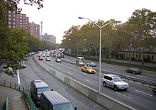
The FDR Drive features a mix of below-grade, at-grade, and elevated sections, as well as three partially covered tunnels. The parkway is mostly three lanes in each direction, except for several small sections.
By law, the current weight limits on the FDR Drive from 23rd Street to the Harlem River Drive in both directions is posted 8,000 pounds (3,600 kg). Buses are not allowed to use the roadway north of 23rd Street because they exceed the road's maximum clearance and weight (although some do, including the MTA's QM7, QM8, QM8 Super Express, QM11 and QM25 express buses). All commercial vehicles (including trucks) are banned from all sections of the FDR Drive, except for a short section just north of the Battery Park Underpass where the northbound lanes temporarily merge with South Street.[3]
Route description[]
The East River Greenway runs below, beside, or above the FDR Drive along nearly its entire length, except for a section between 38th and 60th Streets.[4] A plaque dedicating the East River Drive is visible on the southbound roadway before entering the Gracie Mansion tunnel at 90th Street.
Downtown[]

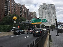
FDR Drive starts at the southern tip of Manhattan at South and Whitehall Streets in the Financial District. It rises from the underground Battery Park Underpass to an elevated viaduct above South Street, with an at-grade connection to South Street at exit 1. The elevated viaduct continues northeast, with an interchange at Brooklyn Bridge at exit 2. The elevated road, also known as the South Street Viaduct, continues until Gouverneur Slip, near the Manhattan Bridge interchange (exit 3), where there are a southbound exit and northbound entrance. From here, the road is at-grade, with a southbound exit/entrance at Grand Street, exit 4.[5]
The FDR Drive continues north through Lower East Side and Alphabet City, and dips under Houston Street at exit 5, in a three-way interchange. It continues north as an at-grade road. Between 14th and 15th Streets, the FDR Drive passes a large Con Edison substation. The substation is surrounded by ramps for the former exit 6, a southbound exit and entrance which was closed after September 11, 2001.[5]
By 18th Street, the FDR Drive curves north onto an elevated viaduct above Avenue C. The elevated viaduct continues until 25th Street to serve the 23rd Street interchange at exit 7. This exit serves the neighborhood of Kips Bay. At 23rd Street, Avenue C continues as the northbound service road for the FDR Drive, while the southbound lanes split from the main highway at 25th Street.[5]
Midtown[]
The FDR Drive continues north as an at-grade road, with the Waterside Plaza complex located along the East River to the east of the parkway. The southbound lanes ascend to a viaduct at 28th Street, and the southbound lanes ascend at 30th Street. There are a southbound entrance and northbound exit at ground level at 28th-30th Streets, where the southbound service road begins again. The northbound exit, labeled exit 8, serves 34th Street in Murray Hill, which is located four blocks north; the FDR Drive service road curves underneath the main highway until 36th Street. Another southbound entrance is located at 34th Street itself, and rises to the viaduct level.[5]
At 38th Street, the northbound-only exit 9 for 42nd Street, serving Turtle Bay, splits from FDR Drive. Exit 9 continues as an elevated ramp until the intersection of 42nd Street and First Avenue, where it becomes the westbound lanes of 42nd Street. The FDR Drive dips onto street level and merges with the northbound service road. The southbound service road continues parallel to the FDR Drive, and the southbound exit 8 splits from the parkway near 41st Street. The southbound service road then becomes the eastbound lanes of 42nd Street.[5]
The headquarters of the United Nations was constructed on a platform above the at-grade FDR Drive from 42nd to 48th Streets.[6] The southbound roadway is inside a later structure resembling a tunnel while the northbound roadway is located just outside of the tunnel.[5] This section is often referred to as the United Nations Tunnel, even though only the westernmost lane of the northbound roadway is under the structure.[6]
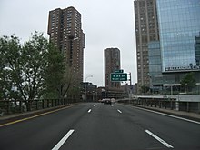
At 48th Street, the FDR Drive emerges from the United Nations tunnel. A northbound ramp from First Avenue merges onto the northbound roadway. The southbound roadway contains two exits: exit 10 at 49th Street, and exit 11 at 53rd Street.[5] At 54th Street, the road enters the Sutton Place Tunnel, which passes under apartment buildings on the east side of Sutton Place and York Avenue until 60th Street.[7] In this tunnel, the southbound roadway is raised and runs over the northbound roadway for northbound access to and from the Queensboro Bridge interchange (exit 12).[5] As part of the design in this area, numerous homes on the river were demolished and rebuilt or otherwise modified to accommodate the highway.[7] At 63rd Street, the southbound lanes descend to ground level, at the same elevation as the northbound lanes.[5]
Uptown[]
From 63rd to 71st Streets, the FDR Drive passes under a series of interconnected at-grade tunnels. The segment from 63rd to 68th Street runs under an annex constructed by Rockefeller University,[8] while the section of roadway between 68th and 71st Streets runs underneath the pilotis of the NewYork–Presbyterian Hospital. Afterward, the FDR Drive continues north at ground level. There is a southbound-only entrance and exit, labeled exit 13, at 71st–73rd Streets, serving Lenox Hill on the Upper East Side. Another southbound-only entrance exists at 79th Street; there is no exit from either direction, nor is there any exit number reserved for this interchange.[5]
From 81st to 90th streets runs a final, enclosed double-decker structure. The southbound roadway is again raised over the northbound roadway in a short segment of the tunnel between 81st and 86th Streets.[5] The promenade of Carl Schurz Park was built over the highway in 1939, near Gracie Mansion, the New York City mayor's residence.[9] There is a southbound entrance to the FDR Drive at the intersection of 92nd Street and York Avenue. York Avenue then parallels the FDR Drive until 96th Street, where York Avenue ends. The FDR Drive ascends onto a short elevated viaduct over the 96th Street interchange (exit 14) then descends to street level again.[5]
The remaining portion of the FDR Drive to the 125th Street interchange (exit 19) is at grade, passing through East Harlem. There is a southbound-only entrance at 102nd Street, as well as a southbound-only exit at 106th Street, labeled exit 15. At 116th Street, there is another southbound-only exit and entrance numbered exit 16. When the FDR Drive reaches 120th Street, there are three northbound exits in quick succession: exit 17 for the Robert F. Kennedy Bridge, exit 18 for the Willis Avenue Bridge, and exit 19 for 125th Street. Exit 17 also contains a southbound exit and entrance to and from the Robert F. Kennedy Bridge, and exit 19 also hosts a southbound entrance. The FDR Drive transitions into the Harlem River Drive and continues north after 125th Street.[5]
History[]
A shorefront parkway in Manhattan along the East River was first proposed by Manhattan Borough President Julius Miller in 1929. The 3.5-mile (5.6 km) parkway would extend from South Street to 54th Street.[10] The first sections of the East River Drive were constructed in the 1930s and were designed by Robert Moses. Moses faced the difficulties of building a parkway/boulevard combination along the East River while minimizing disruptions to residents. Many property owners along the East River Drive, especially in Midtown, opposed the boulevard unless noise mitigation measures were added.[11]
The section from 125th Street and the Triborough Bridge ramp south to 92nd Street was completed in 1936.[12] The sections from 92nd Street down to Battery Park (with the exception of a section from 42nd to 49th Streets, located underneath the headquarters of the United Nations) were built as a boulevard running at street level.[13] The first "downtown" section of the boulevard, between Grand and 12th Streets, was completed in June 1937.[14] Two more downtown sections, from 12th to 14th Streets and then from 14th to 18th Streets, were opened in 1939.[15] A short connector from Grand to Montgomery Street was completed in May 1940, which meant that the boulevard was now continuous from Montgomery to 30th Streets.[16] The next month, a large stretch from 49th to 92nd Streets opened. By this point, the only contiguous section that remained to be completed was the stretch between 30th and 49th Streets.[17]
Around this time, city officials started making plans for reconstructing existing sections of the boulevard so that several intersections would be grade-separated or double-decked. A plan to build a three-level section from 81st to 89th Streets was released in April 1940,[18] followed by an East River Drive overpass over 96th Street in June.[19] Due to a bulkhead restriction, a section from 51st to 60th Streets was already being built with two decks.[18]
The section of the East River Drive from 23rd to 34th Streets was completed in October 1941.[20] Known as the Bristol Basin, this section was built on wartime rubble dumped by cargo ships returning from Bristol, England, during World War II. The German Luftwaffe bombed Bristol heavily. After delivering war supplies to the British, the ships' crews loaded rubble onto the ships for ballast, then sailed back to New York, where construction crews made use of it.[21] On June 29, 1942, a plaque commemorating the use of rubble was dedicated by Mayor Fiorello LaGuardia,[22] and is currently installed at the Waterside Plaza complex. The final part of the original boulevard, between 34th and 49th Streets, opened in May 1942.[23] Future reconstruction designs from 1948 to 1966 converted the FDR Drive into the full parkway that is in use today.[13]
Upon the death of Franklin Delano Roosevelt, the East River Drive was dedicated to him in June 1945.[24] The drive is now commonly called the "FDR Drive".[25]
An elevated ramp between 18th and 25th Streets, serving as an extension of the highway south of 23rd Street, was completed in 1949,[26] replacing an at-grade section.[27] Another elevated highway above South Street, connecting the at-grade parkway north of Grand Street to the Battery Park Underpass and Brooklyn–Battery Tunnel at the southern tip of Manhattan, was completed in May 1954.[28]
In Kips Bay, the FDR Drive is located on a viaduct between 30th and 37th Streets. The southbound and northbound roadways rise onto a viaduct separately between 28th and 30th Streets; the southbound roadway ascends onto the viaduct at 28th Street, followed by the northbound roadway at 30th Street, and the two roadways merge into a single structure at 32nd Street. At this point, there is a two-lane shoulder on the left side of the northbound roadway, with one of the lanes cordoned off by a short concrete barrier. There is a provision for a southbound exit and northbound entrance at 30th Street, which was built in 1967 and would have connected to the Mid-Manhattan Expressway. However, after plans for the expressway were abandoned, this exit was never used, largely because there was already an exit four blocks north, at 34th Street. The unused exit was then blocked with a semi-permanent concrete barricade.[29]
Exit 6, at 15th Street, formerly passed through a Con Edison substation, which handles most of the electricity for lower Manhattan. It was closed after the September 11, 2001 attacks after city and ConEd officials concluded it was too risky to allow such easy access to such a critical piece of infrastructure.[30] The exit was permanently removed in 2014 after the New York State Department of Transportation received notification from the New York City Police Department that the exit would not be re-opened since the ConEd facility was deemed a potential terrorist target. East 15th Street, as well as a corresponding entrance ramp from 14th Street, were also closed east of Avenue C, except to ConEdison and law enforcement vehicles. All signage of exit 6 was removed in early 2016.[5]
Transportation[]
The SIM3, SIM6, SIM10, SIM11, SIM31, X37 and X38 express buses use the FDR Drive between its start in Lower Manhattan and 23rd Street.[31][32][33] In addition, the QM7, QM8, QM8 Super Express, QM11 and QM25 use the FDR Drive between the Brooklyn Bridge exit and 34th Street[34][35]
The BM1, BM2, BM3 and BM4 buses use the FDR between Brooklyn Bridge and 23rd Street during the off-peak hours, but during the peak hour, "Midtown Express" buses skip Downtown, running directly up the FDR to 23rd.[33][36]
Exit list[]
The entire route is in the New York City borough of Manhattan.
| Location | mi [1][5][37] | km | Exit | Destinations | Notes |
|---|---|---|---|---|---|
| Battery Park City | 0.00 | 0.00 | – | Southern terminus; exit 1 on NY 9A | |
| Battery Park | 0.1– 0.5 | 0.16– 0.80 | Battery Park Underpass | ||
| Financial District | 0.6 | 0.97 | 1 | South Street – Battery Park, Staten Island Ferry | No southbound signage for South Street |
| Two Bridges | 1.41 | 2.27 | 2 | Brooklyn Bridge, Manhattan Civic Center | Access to Civic Center via Pearl Street |
| 2.4 | 3.9 | 3 | South Street – Manhattan Bridge | Southbound exit and northbound entrance | |
| Lower East Side | 2.6 | 4.2 | 4 | Grand Street – Williamsburg Bridge | Southbound exit and entrance |
| 3.09 | 4.97 | 5 | East Houston Street – Williamsburg Bridge | Formerly signed for Holland Tunnel | |
| East Village | 3.70 | 5.95 | 6 | East 15th Street | Southbound exit and entrance (via 14th Street); permanently closed since 2002 due to post-9/11 security concerns[30] |
| Peter Cooper Village | 4.30 | 6.92 | 7 | East 20th Street / East 23rd Street | No southbound signage for East 20th Street; also serves Avenue C |
| Kips Bay | 4.6 | 7.4 | – | East 30th Street | Southbound entrance only |
| Murray Hill | 4.86 | 7.82 | 8 | ||
| 4.9 | 7.9 | 9 | East 42nd Street | Northbound exit only | |
| Midtown East | 5.2– 5.5 | 8.4– 8.9 | Tunnel under United Nations Headquarters | ||
| 5.6 | 9.0 | 10 | East 49th Street | Southbound exit and northbound entrance (from 1st Avenue) | |
| Sutton Place | 5.8 | 9.3 | 11 | East 53rd Street | Southbound exit only |
| 5.8– 6.1 | 9.3– 9.8 | Tunnel under Sutton Place | |||
| Upper East Side | 6.1– 6.3 | 9.8– 10.1 | 12 | Northbound left exit/entrance via 61st/62nd Streets; southbound exit/entrance via 63rd Street | |
| 6.3– 6.7 | 10.1– 10.8 | Tunnel under Rockefeller University / NewYork–Presbyterian Hospital / Hospital for Special Surgery | |||
| 6.7 | 10.8 | 13 | East 71st Street | Southbound exit and entrance (from 73rd Street) | |
| Yorkville | 7.0 | 11.3 | – | East 79th Street | Southbound entrance only |
| 7.2– 7.6 | 11.6– 12.2 | Tunnel under Carl Schurz Park | |||
| East Harlem | 7.96 | 12.81 | 14 | East 96th Street | Also serves East 97th Street and York Avenue; southbound entrance via 92nd Street |
| 8.63 | 13.89 | 15 | East 106th Street | Southbound exit and entrance (from East 102nd Street) | |
| 9.15 | 14.73 | 16 | East 116th Street | Southbound exit and entrance | |
| 9.68 | 15.58 | 17 | Access via unsigned NY 900G; exit 46 on I-278; also serves Randall's Island | ||
| 18 | Northbound exit only | ||||
| – | Continuation north | ||||
1.000 mi = 1.609 km; 1.000 km = 0.621 mi
| |||||

References[]
- ^ Jump up to: a b "2014 Traffic Data Report for New York State" (PDF). New York State Department of Transportation. July 22, 2015. Retrieved January 14, 2020.
- ^ Jump up to: a b Anderson, Steve. "FDR Drive". NYCRoads. Retrieved January 19, 2012.[self-published source]
- ^ New York City Department of Transportation (2013). "Parkway Truck Restrictions". New York City Department of Transportation. Retrieved June 23, 2013.
- ^ "East River Greenway inches forward with $100M cash infusion". Curbed NY. Retrieved October 17, 2017.
- ^ Jump up to: a b c d e f g h i j k l m n o Google (January 14, 2020). "FDR Drive" (Map). Google Maps. Google. Retrieved January 14, 2020.
- ^ Jump up to: a b "U. N. to Make $2,250,000 Steel Contract Soon To Start Second Unit of East River Project" (PDF). The New York Times. June 20, 1949. ISSN 0362-4331. Retrieved December 22, 2017.
- ^ Jump up to: a b Gray, Christopher (May 15, 1988). "Streetscapes: Franklin D. Roosevelt Drive; Institutions Use Air Rights Over a Multilevel Marvel". The New York Times. Retrieved May 9, 2016.
- ^ Veilleux, Zach (May 14, 2014). "NY City Council approves new Rockefeller laboratory building". Rockefeller University. Archived from the original on May 6, 2016. Retrieved May 9, 2016.
The Rockefeller University's proposal to build a two-story, 160,000-square-foot [15,000 m2] building over the FDR Drive adjacent to its campus passed an important milestone today with the City Council's vote to approve the plan.
- ^ New York City Department of Parks and Recreation. "Carl Schurz Park". New York City Department of Parks and Recreation. Retrieved May 9, 2016.
- ^ "EASE RIVER DRIVE TO COST $9,000,000 PLANNED BY MILLER; Proposal for Shore Road From South Street to 54th Laid Before Estimate Board. CITY SHARE $4,000,000 Private Owners Would Have to Pay Rest, Under Old Water Grants, Says Borough Head. LINK TO WEST SIDE IN VIEW Road Like Thames Embankment Expected to Create New Taxable Property Worth Millions. Like Victoria Embankment. Part to Be Eighty Feet Wide. EAST RIVER DRIVE PLANNED BY MILLER Plan Additional Wharfage. Eighteen Months for Building". The New York Times. January 28, 1929. Retrieved July 3, 2018.
- ^ "Land Owners Fight East River Drive Plan; Want It Roofed, if Built, to Stifle Noise". The New York Times. September 20, 1936. ISSN 0362-4331. Retrieved March 22, 2018.
- ^ "EAST DRIVE LINK OPENS; Southbound Lanes Ready Today From 92d to 122d Streets". The New York Times. October 31, 1936. ISSN 0362-4331. Retrieved March 22, 2018.
- ^ Jump up to: a b New York City Department of Parks and Recreation. "East River Park Highlights". New York City Department of Parks & Recreation.
- ^ "NEW SECTION READY ON EAST SIDE DRIVE; Mile-Long Stretch, Between Grand and 12th Sts., to Be Opened on Tuesday 35-ACRE PARK ADJOINS IT Six-Lane Auto Highway Later Will Form Part of Road Chain Circling Manhattan". The New York Times. June 24, 1937. ISSN 0362-4331. Retrieved March 22, 2018.
- ^ "SECTION OF DRIVE ON EAST SIDE OPEN; Stretch From 14th to 18th Sts. Placed in Commission by Isaacs and Party". The New York Times. December 28, 1939. ISSN 0362-4331. Retrieved March 22, 2018.
- ^ "DRIVE SECTION OPEN TODAY; East River Road, Montgomery to 30th St., Ready for Use". The New York Times. May 17, 1940. ISSN 0362-4331. Retrieved March 22, 2018.
- ^ "NEW LINK IS OPENED IN EAST RIVER DRIVE; Along the Section of East River Drive Which Was Dedicated Yesterday". The New York Times. June 19, 1940. ISSN 0362-4331. Retrieved March 22, 2018.
- ^ Jump up to: a b "DETAILS ARE GIVEN OF NEW DRIVE LINK; Isaacs Makes Public Description of Triple-Deck Section". The New York Times. April 29, 1940. ISSN 0362-4331. Retrieved March 22, 2018.
- ^ "City to Act Today on East Drive Link; Plan for Ninety-Sixth Street Overpass Along the East River Drive". The New York Times. June 6, 1940. ISSN 0362-4331. Retrieved March 22, 2018.
- ^ "EAST RIVER DRIVE GETS A NEW LINK; Mayor Hails It as Example of 'Perfect Engineering and Clean Financing'". The New York Times. October 23, 1941. ISSN 0362-4331. Retrieved March 22, 2018.
- ^ Pollak, Michael (June 26, 2009). "FYI Column". The New York Times. Retrieved June 28, 2009.
- ^ "Bricks of Bombed British Homes Used in City Highway Are Marked; La Guardia Warns at Dedication That We May Get Bombings Like Those of Britain -- Haggard Stresses Anglo-U.S. Unity". timesmachine.nytimes.com. Retrieved July 13, 2021.
- ^ "EAST RIVER DRIVE IS OPENED IN FULL; Final Link, 34th to 49th Sts., Completes 7 1/2-Mile Stretch That Cost $46,000,000 WORK OF 3 BOROUGH HEADS Mayor Praises Cooperation of Levy, Isaacs, Nathan and Private Industries". The New York Times. May 26, 1942. ISSN 0362-4331. Retrieved March 22, 2018.
- ^ "Council Votes to Name East Drive for Roosevelt". The New York Times. June 29, 1945. ISSN 0362-4331. Retrieved March 22, 2018.
- ^ New York City Department of Parks and Recreation (December 20, 2001). "FDR Drive: Historical Sign". New York City Department of Parks & Recreation.
- ^ Bennett, Charles G. (June 7, 1949). "MAYOR AND ROGERS OPEN RAISED ROAD; East Side Span Takes Express Highway From 18th to 25th St. -- Other Links Pushed". The New York Times. ISSN 0362-4331. Retrieved March 22, 2018.
- ^ "City Will Raise Part of East River Drive". The New York Times. March 8, 1948. ISSN 0362-4331. Retrieved March 22, 2018.
- ^ "UNDERPASS LINKED TO EAST SIDE DRIVE; Ceremony at Battery End of Elevated Highway Officially Completes Peripheral Road MAYOR LAUDS ENGINEERS Borough President Speaks at Gathering of 2,000 at South Street and Coenties Slip". The New York Times. May 29, 1954. ISSN 0362-4331. Retrieved March 22, 2018.
- ^ "NEW EXIT RAMP JUST A DEAD END; East River Drive Connects to an Unbuilt Expressway A Link for Expressway 'Not a Mistake'". The New York Times. November 26, 1967. Retrieved July 6, 2018.
- ^ Jump up to: a b Siff, Andrew. "Since 2002, FDR Drive's Exit 6 Mysteriously Says 'Closed'". New York: WNBC. Retrieved February 10, 2014.
- ^ MTA Regional Bus Operations. "SIM3 bus schedule" (PDF).
MTA Regional Bus Operations. "SIM6 bus schedule" (PDF).
MTA Regional Bus Operations. "SIM10 bus schedule" (PDF).
MTA Regional Bus Operations. "SIM11 bus schedule" (PDF).
MTA Regional Bus Operations. "SIM31 bus schedule" (PDF).
MTA Regional Bus Operations. "X37 bus schedule" (PDF).
MTA Regional Bus Operations. "X38 bus schedule" (PDF). - ^ "Staten Island Bus Map" (PDF). Metropolitan Transportation Authority. January 2020. Retrieved December 1, 2020.
- ^ Jump up to: a b "Brooklyn Bus Map" (PDF). Metropolitan Transportation Authority. October 2020. Retrieved December 1, 2020.
- ^ "Queens Bus Map" (PDF). Metropolitan Transportation Authority. September 2019. Retrieved December 1, 2020.
- ^ MTA Regional Bus Operations. "QM7 bus schedule" (PDF).
MTA Regional Bus Operations. "QM8 bus schedule" (PDF).
MTA Regional Bus Operations. "QM25 bus schedule" (PDF).
MTA Regional Bus Operations. "QM11 bus schedule" (PDF). - ^ MTA Regional Bus Operations. "BM1 bus schedule" (PDF).
MTA Regional Bus Operations. "BM2 bus schedule" (PDF).
MTA Regional Bus Operations. "BM3 bus schedule" (PDF).
MTA Regional Bus Operations. "BM4 bus schedule" (PDF). - ^ "New York County Inventory Listing" (CSV). New York State Department of Transportation. August 7, 2015. Retrieved September 5, 2017.
External links[]
Route map:

| ( • help)
|
| Wikimedia Commons has media related to Franklin D. Roosevelt East River Drive. |
- FDR Drive at Alps' Roads
- FDR Drive (Greater New York Roads)
| hide Authority control | |
|---|---|
| General | |
| National libraries | |
| Other | |
- Parkways in New York City
- Monuments and memorials to Franklin D. Roosevelt in the United States
- Transportation in Manhattan