Farashband County
Farashband County
شهرستان فراشبند | |
|---|---|
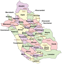 Location in Fars Province | |
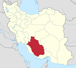 Location of Fars Province in Iran | |
| Coordinates: 28°45′N 52°15′E / 28.750°N 52.250°ECoordinates: 28°45′N 52°15′E / 28.750°N 52.250°E | |
| Country | |
| Province | Fars |
| Capital | Farashband |
| Bakhsh (Districts) | Central District, Dehram District |
| Population (2006) | |
| • Total | 38,679 |
| Time zone | UTC+3:30 (IRST) |
| • Summer (DST) | UTC+4:30 (IRDT) |
| Farashband County can be found at GEOnet Names Server, at this link, by opening the Advanced Search box, entering "9206527" in the "Unique Feature Id" form, and clicking on "Search Database". | |
Farashband County (Persian: شهرستان فراشبند) is a county in Fars Province in Iran. The capital of the county is Farashband.[1] At the 2006 census, the county's population was 38,679, in 8,474 families.[2] The county is subdivided into two districts: the Central District and Dehram District. The county has three cities: Farashband, Nujin, and Dehram.
References[]
- ^ Gitashenasi Province Atlas of Iran
اطلس گیتاشناسی استانهای ایران Archived May 22, 2007, at the Wayback Machine - ^ "Census of the Islamic Republic of Iran, 1385 (2006)" (Excel). Statistical Center of Iran. Archived from the original on 2011-11-11.

| Capital | |||||||||||||||||||||
|---|---|---|---|---|---|---|---|---|---|---|---|---|---|---|---|---|---|---|---|---|---|
| Districts |
| ||||||||||||||||||||
This Farashband County location article is a stub. You can help Wikipedia by . |
Categories:
- Farashband County
- Counties of Fars Province
- Farashband County geography stubs