Fingal Head Light
 Fingal Head Light, 2009 | |
 | |
| Location | Fingal Head New South Wales Australia |
|---|---|
| Coordinates | 28°12′0.07″S 153°34′14.98″E / 28.2000194°S 153.5708278°ECoordinates: 28°12′0.07″S 153°34′14.98″E / 28.2000194°S 153.5708278°E |
| Constructed | 1872 (post light) |
| Foundation | concrete slab |
| Construction | sandstone masonry tower |
| Tower height | 23 feet (7.0 m) |
| Tower shape | cylindrical tower with balcony and lantern |
| Markings | white tower and lantern |
| Operator | Australian Maritime Safety Authority |
| Heritage | Department of Conservation & Land Management |
| First lit | 1878 |
| Automated | 1920 |
| Focal height | 80 feet (24 m) |
| Lens | fourth order catadioptric[1] |
| Light source | mains power |
| Intensity | white: 37,000 cd red: 9,000 cd[2] |
| Range | white: 17 nautical miles (31 km; 20 mi) red: 14 nautical miles (26 km; 16 mi) |
| Characteristic | Fl WR 5s. |
| Admiralty no. | K2844 |
| NGA no. | 111-5872 |
| ARLHS no. | AUS-073 |

Fingal Head Light is an active lighthouse located at Fingal Head, New South Wales, Australia, a headland about 5 kilometres (3.1 mi) south of Point Danger, which marks the Queensland border.
History[]

The station was first established on 19 February 1872, a wooden pole structure of approximately 30 feet (9.1 m), holding a fixed kerosene wick burner[3] which shone a fixed white light with an intensity of 1,000 cd.[2] It was described by a daughter of William Arnold, the first lighthouse keeper, as being shaped like a large meat safe, mounted on a wooden structure resembling a pigeon loft. The keeper had to row from the Tweed Heads Pilot Station each day and light the lantern at sunset, and a hut was constructed for him to stay in.[3]
In October 1878 the Maritime Board of New South Wales decided to construct a modern lighthouse at the location. It was the third of five lighthouses of similar design designed by James Barnet in 1878–80, the other four being Richmond River Light, Clarence River Light (now demolished), Tacking Point Lighthouse and Crowdy Head Light.[1] It originally had a porch and an annexe serving as oil room. A four-room, single-storey lighthouse keeper's house was constructed about 20 metres (66 ft) northwest of the tower.[3] The lighthouse and keeper's cottage were constructed by Joseph William Mortley and Shepherd who were successful with their government tender.
On 15 June 1920 the light was converted to an automatic carbide lamp (acetylene gas) apparatus, with an intensity of 1,500 cd, and altered to group flashing. Soon after, the station was demanned and all buildings other than the tower were demolished.[2][1]
In 1980 the light was converted to electricity.[3] The current light source is a modern FA-251 Beacon with a 12 Volt 75 Watt HL-2000 quartz halogen lamp. It is fed by mains electricity with a Battery standby.[2] It revolves once every 30 seconds.[3]
The current light characteristic is a flash every five seconds, red to east and white to other directions (Fl.W.R. 5s). It is partially obscured.[4]
Structure[]
The circular tower is made from bricks and cement rendered from the outside. It is capped by an oversailing bluestone platform at 12 feet (3.7 m) above ground levels, supported by shaped bluestone corbels. The platform is surrounded by a handrail of metal standards and rails. It is topped by the domed lantern housing the optical apparatus, a fourth order catadioptric.[1]
Site operation[]
The light is operated by Roads and Maritime Services (formerly NSW Maritime).[5] The site is managed by the New South Wales Department of Lands.
Visiting[]
The light is accessible by road from the Pacific Highway just south of the Tweed River. Parking is provided, and there is also a public beach and a picnic area just north of the lighthouse. The tower itself, however, is closed to the public.[6]
See also[]
Notes[]
- ^ Jump up to: a b c d RNE263.
- ^ Jump up to: a b c d Lighthouses of Australia Inc.
- ^ Jump up to: a b c d e Tweed Heads Historical Society.
- ^ List of Lights
- ^ According to NSW Maritime, though Rowlett says Australian Maritime Safety Authority
- ^ Rowlett.
References[]
| Wikimedia Commons has media related to Fingal Head Light. |
- List of Lights, Pub. 111: The West Coasts of North and South America (Excluding Continental U.S.A. and Hawaii), Australia, Tasmania, New Zealand, and the Islands of the North and South Pacific Oceans (PDF). List of Lights. United States National Geospatial-Intelligence Agency. 2009. p. 120.
- Rowlett, Russ. "Lighthouses of Australia: New South Wales". The Lighthouse Directory. University of North Carolina at Chapel Hill. Retrieved 29 August 2010.
- "The Fingal Head Lighthouse". Lighthouses of New South Wales. Lighthouses of Australia Inc.
- Searle, Garry. "List of Lighthouses - New South Wales". Lighthouses of Australia. SeaSide Lights.
- "Fingal Lighthouse « Tweed Heads Historical Society". tweedhistory.org.au. Archived from the original on 27 August 2010. Retrieved 31 August 2010.
- "Lighthouse Lights - NSW Maritime". maritime.nsw.gov.au. Retrieved 3 October 2010.
- "Fingal Head Lighthouse (listing RNE263)". Australia Heritage Places Inventory. Department of Sustainability, Environment, Water, Population and Communities.
| hide | ||
|---|---|---|
| North Coast | 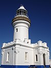 | |
| Outside Sydney Harbour | ||
| Inside Sydney Harbour | ||
| South Coast | ||
| ||
- Lighthouses completed in 1880
- Lighthouses in New South Wales
- 1872 establishments in Australia
- Tweed Heads, New South Wales