Tacking Point Lighthouse
 Tacking Point Lighthouse, 2012 | |
 | |
| Location | Port Macquarie New South Wales Australia |
|---|---|
| Coordinates | 31°28′32″S 152°56′14″E / 31.4755°S 152.9372°ECoordinates: 31°28′32″S 152°56′14″E / 31.4755°S 152.9372°E |
| Tower | |
| Constructed | 1879 |
| Construction | cement render bricks |
| Height | 8 m (26 ft)[1] |
| Shape | cylindrical tower with balcony and lantern |
| Markings | white tower, lantern and attached storeroom, blue balcony rail |
| Operator | Australian Maritime Safety Authority |
| Light | |
| Automated | 1919 |
| Focal height | 34 m (111 ft) |
| Light source | mains power |
| Intensity | 12,800 cd |
| Range | 16 nmi (30 km; 18 mi) |
| Characteristic | Fl (4) W 20s. |

Tacking Point Lighthouse is Australia's thirteenth oldest lighthouse. It was built on a rocky headland about 8 kilometres south of Port Macquarie in 1879 by Shepherd and Joseph William Mortley, to a design by the New South Wales Colonial Architect, James Barnet. It is operated by the Australian Maritime Safety Authority and is classified by the National Trust of Australia (NSW).
Tacking Point was named by explorer Matthew Flinders in 1802 during his 1802–1803 circumnavigation of Australia.[2] Its nearest lighthouses are Smoky Cape Lighthouse at South West Rocks, to the north, and Crowdy Head Light, to the south.
History[]
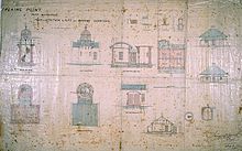
In the mid-nineteenth century, there were few lights in the Tacking Point area and over 20 ships were wrecked. The first occurred in December 1823 when the schooner Black Jack was wrecked on the Port Macquarie bar.[3] Consequently, in 1879, a fixed catadioptric light of less than 1000 candelas was erected on Tacking Point. It was the fourth of five small navigational lighthouses built to a design by James Barnet.[4] The other four lighthouses were Crowdy Head Light, Fingal Head Light, Richmond River Light and Clarence River Light (now demolished).[5] Only two of these lighthouses, Tacking Point and Crowdy Head still have a storeroom attached.[5]
The lighthouse was built of cement-rendered bricks and only needed to be 8 metres high due to the elevation of the site. In 1919, the light was converted from wick oil light to automatic acetylene operation, and was de-manned in 1920.[6] The light was converted to mains electricity in 1974.[4] The foundations of the keeper's cottage are still visible.
Management of the lighthouse is shared by three government authorities: the New South Wales Department of Lands owns the lighthouse; Transport for NSW operates the light;[7] and the Port Macquarie-Hastings Council manages the site. Vandalism has been a problem in the early 2000s. Resolving the issue has been complicated by the split management.[8]
Tourism[]

The Lighthouse headland marks the end of the circa 9 km Coastal Walk from Town Beach to Lighthouse Beach being built by the Port Macquarie-Hastings Council. The lighthouse is also a popular site for whale watching.[8] The area is used for surfing and there is a surf life-saving club at the neighbouring Lighthouse Beach.
See also[]
Notes[]
- ^ List of Lights says a slightly lower 24 feet (7.3 m)
- ^ Darroch, Donald (2003) East Coast Australia: Sydney to Cairns, Footprint Travel Guides, p. 183
- ^ [1]
- ^ a b Port Macquarie-Hastings Council: Tacking Point Lighthouse
- ^ a b Letter by Editor Steve Merson, Bulletin of the Lighthouses of Australia, Inc, No. 8, December 2003
- ^ "Tacking Point Lighthouse". Lighthouses of New South Wales. Lighthouses of Australia Inc.
- ^ "Lighthouse Lights – NSW Maritime". maritime.nsw.gov.au. Retrieved 3 October 2010.
- ^ a b "Tacking Point Lighthouse vandalised again", Lighthouses of Australia, Inc. Bulletin, 8 (4) July/August 2005
References[]
| Wikimedia Commons has media related to Tacking Point Light. |
- Rowlett, Russ. "Lighthouses of Australia: Northern New South Wales". The Lighthouse Directory. University of North Carolina at Chapel Hill. Retrieved 24 August 2008.
- List of Lights, Pub. 111: The West Coasts of North and South America (Excluding Continental U.S.A. and Hawaii), Australia, Tasmania, New Zealand, and the Islands of the North and South Pacific Oceans (PDF). List of Lights. United States National Geospatial-Intelligence Agency. 2009. p. 133.
| North Coast | 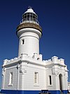 | |
|---|---|---|
| Outside Sydney Harbour | ||
| Inside Sydney Harbour | ||
| South Coast | ||
| ||
- Pages using infobox lighthouse with possibly incorrect light source parameter
- Lighthouses completed in 1879
- Lighthouses in New South Wales
- 1879 establishments in Australia
- James Barnet buildings