Fort St. John, British Columbia
Fort St. John | |
|---|---|
| City of Fort St. John | |
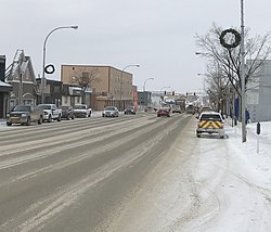 Downtown Fort St. John | |
|
Flag | |
| Nickname(s): FSJ | |
 Fort St. John Location of Fort St. John | |
| Coordinates: 56°15′09″N 120°50′48″W / 56.25250°N 120.84667°WCoordinates: 56°15′09″N 120°50′48″W / 56.25250°N 120.84667°W | |
| Country | Canada |
| Province | British Columbia |
| Regional District | Peace River |
| Incorporated | 31 Dec 1947 (village) |
| Government | |
| • Mayor | Lori Ackerman |
| • Governing Body | Fort St. John City Council (Byron Stewart, Gord Klassen, Trevor Bolin, Tony Zabinsky, Lilia Hansen) |
| • MLA | Dan Davies, BC Liberal |
| • MP | Bob Zimmer, Conservative |
| Area | |
| • City | 22.69 km2 (8.76 sq mi) |
| • Metro | 620.80 km2 (239.69 sq mi) |
| Elevation | 690 m (2,260 ft) |
| Population (2016)[1] | |
| • City | 20,155 |
| • Density | 820.2/km2 (2,124/sq mi) |
| ��� Metro | 28,396 |
| • Metro density | 42.5/km2 (110/sq mi) |
| Time zone | UTC−07:00 (Mountain Time Zone) |
| Forward sortation area | V1J |
| Area code(s) | 250, 778, 236, 672 |
| Website | City of Fort St. John website |


Fort St. John is a city located in northeastern British Columbia, Canada. The most populous municipality in the Peace River Regional District, the city encompasses a total area of about 22 square kilometres (8.5 sq mi) with 20,155 residents recorded in the 2016 Census. Located at Mile 47 of the Alaska Highway, it is one of the largest cities between Dawson Creek, British Columbia and Delta Junction, Alaska. Established in 1794 as a trading post, Fort St. John is the oldest European-established settlement in present-day British Columbia. The city is served by the Fort St. John Airport. The municipal slogan is Fort St. John: The Energetic City.
History[]
Fort St. John is located on the traditional territory of the Dane-zaa First Nation people. Over the 19th and 20th centuries, the settler community has been moved a number of times for varying economic reasons. The present location is thought to be its sixth. The original trading post built in the area was named Rocky Mountain House (not to be confused with the modern Alberta town by that name). It was established one year after Sir Alexander Mackenzie explored the area in 1793. One of a series of forts along the Peace River constructed to service the fur trade, it was located southwest of the present site of Fort St. John. The Dane-zaa and Sikanni First Nations used it as a trading post. It was also used as a supply depot for further expeditions into the territory. The fort closed in 1805. was built in 1806 by the North West Company. It was renamed Fort St. John in 1821 following the purchase of the North West Company by the Hudson's Bay Company. This fort was located about 500 m (1,600 ft) downstream from the mouth of the Beatton River, which at that time was known as the Pine River. It was shut down in 1823. The site was designated a National Historic Site of Canada in 1958.[2][3]
After a lapse of nearly forty years, Fort St. John was reopened in 1860 on the south side of the Peace River, directly south of the present community. It was moved in 1872 by directly across the river. This community lasted until 1925 when the river ceased to be the main avenue of transportation and the fort was moved closer to where settlers were establishing homesteads. The new town was constructed at Fish Creek, northwest of the present community, on the new trail to Fort Nelson. It did not shut down until 1975. In 1928, C. M. Finch moved his general store to two quarters of land where he also built a government building to house the land, telegraph and post offices. The present site for the town was firmly established after he donated 5 acres (2.0 ha) for a Roman Catholic church and additional land for a hospital.
Geography[]
Climate[]
Fort St. John, located on the upland prairies north of the Peace River, experiences a cold humid continental climate (close to subarctic), with cold winters and warm summers. Although winters can be frigid, the area has milder winters than much of the rest of Canada (especially considering its relatively northerly latitude) due to the influence of the nearby Rocky Mountains. They tend to block arctic air masses coming in from the north/northwest, although they can certainly still penetrate the area. A predominantly southwesterly wind blows through town, with wind speeds averaging around 13.7 km (8.5 mi).[4] Fort St. John uses Mountain Standard Time all year (same as Pacific Daylight Time in summer), and because of its northerly latitude experiences short daylight hours in winter and long daylight hours in summer.
Fort St. John is east of the Rocky Mountains, and thus has a climate much more similar to the prairies than the British Columbia interior west of the mountains. The frost-free period is much longer east of the mountains than west, and thus the Peace River area including Fort St. John can grow crops that cannot be grown in most of the province such as wheat and canola.
Fort St. John is one of the sunniest places in the province, especially in the winter and spring. The city holds British Columbia's record for most sunshine ever recorded in March (247.4 hours in 1965), May (373.5 hours in 1972), and November (141.3 hours in 1976).[5]
The highest temperature ever recorded in Fort St. John was 38.3 °C (101 °F) on 16 July 1941.[6] The coldest temperature ever recorded was −53.9 °C (−65 °F) on 11 January 1911.[7]
| hideClimate data for Fort St. John Airport, 1981–2010 normals, extremes 1910–present[a] | |||||||||||||
|---|---|---|---|---|---|---|---|---|---|---|---|---|---|
| Month | Jan | Feb | Mar | Apr | May | Jun | Jul | Aug | Sep | Oct | Nov | Dec | Year |
| Record high humidex | 12.7 | 12.4 | 17.3 | 27.4 | 31.5 | 34.3 | 37.4 | 34.5 | 32.6 | 25.4 | 16.2 | 11.2 | 37.4 |
| Record high °C (°F) | 12.9 (55.2) |
15.0 (59.0) |
18.0 (64.4) |
28.5 (83.3) |
32.2 (90.0) |
31.7 (89.1) |
38.3 (100.9) |
33.6 (92.5) |
32.2 (90.0) |
26.7 (80.1) |
18.3 (64.9) |
15.0 (59.0) |
38.3 (100.9) |
| Average high °C (°F) | −8.7 (16.3) |
−5.1 (22.8) |
0.1 (32.2) |
9.1 (48.4) |
15.5 (59.9) |
19.6 (67.3) |
21.7 (71.1) |
20.5 (68.9) |
15.2 (59.4) |
7.7 (45.9) |
−2.9 (26.8) |
−7.4 (18.7) |
7.1 (44.8) |
| Daily mean °C (°F) | −12.8 (9.0) |
−9.6 (14.7) |
−4.6 (23.7) |
3.9 (39.0) |
9.8 (49.6) |
14.1 (57.4) |
16.2 (61.2) |
14.9 (58.8) |
10.1 (50.2) |
3.6 (38.5) |
−6.6 (20.1) |
−11.4 (11.5) |
2.3 (36.1) |
| Average low °C (°F) | −16.9 (1.6) |
−14.0 (6.8) |
−9.2 (15.4) |
−1.3 (29.7) |
4.0 (39.2) |
8.6 (47.5) |
10.7 (51.3) |
9.2 (48.6) |
4.9 (40.8) |
−0.6 (30.9) |
−10.2 (13.6) |
−15.3 (4.5) |
−2.5 (27.5) |
| Record low °C (°F) | −53.9 (−65.0) |
−50.0 (−58.0) |
−37.8 (−36.0) |
−31.1 (−24.0) |
−13.1 (8.4) |
−5.6 (21.9) |
−4.4 (24.1) |
−2.9 (26.8) |
−12.8 (9.0) |
−25.0 (−13.0) |
−39.2 (−38.6) |
−50.6 (−59.1) |
−53.9 (−65.0) |
| Record low wind chill | −59.5 | −59.3 | −48.7 | −37.8 | −19.9 | −6.2 | 0.0 | −7.8 | −18.4 | −35.3 | −58.3 | −53.9 | −59.5 |
| Average precipitation mm (inches) | 25.4 (1.00) |
19.0 (0.75) |
23.7 (0.93) |
20.0 (0.79) |
37.9 (1.49) |
65.6 (2.58) |
75.2 (2.96) |
51.2 (2.02) |
44.7 (1.76) |
30.8 (1.21) |
29.2 (1.15) |
22.0 (0.87) |
444.7 (17.51) |
| Average rainfall mm (inches) | 0.4 (0.02) |
0.4 (0.02) |
0.7 (0.03) |
9.7 (0.38) |
31.9 (1.26) |
65.6 (2.58) |
75.2 (2.96) |
51.1 (2.01) |
40.0 (1.57) |
13.3 (0.52) |
3.4 (0.13) |
0.7 (0.03) |
292.4 (11.51) |
| Average snowfall cm (inches) | 32.7 (12.9) |
25.3 (10.0) |
28.7 (11.3) |
12.7 (5.0) |
6.4 (2.5) |
0.0 (0.0) |
0.0 (0.0) |
0.1 (0.0) |
4.8 (1.9) |
19.6 (7.7) |
32.5 (12.8) |
26.8 (10.6) |
189.6 (74.6) |
| Average precipitation days (≥ 0.2 mm) | 10.6 | 8.4 | 9.0 | 6.9 | 8.8 | 11.1 | 12.9 | 10.4 | 10.4 | 9.6 | 11.1 | 9.5 | 118.5 |
| Average rainy days (≥ 0.2 mm) | 0.6 | 0.4 | 0.7 | 3.8 | 7.9 | 11.1 | 12.9 | 10.4 | 10.0 | 5.5 | 2.1 | 0.6 | 66.0 |
| Average snowy days (≥ 0.2 cm) | 10.8 | 9.0 | 8.8 | 4.0 | 1.5 | 0.0 | 0.0 | 0.0 | 1.0 | 5.4 | 10.3 | 9.5 | 60.3 |
| Average relative humidity (%) (at 15:00 LST) | 68.5 | 62.9 | 53.8 | 42.6 | 41.1 | 45.7 | 49.3 | 50.6 | 52.4 | 57.9 | 72.3 | 71.5 | 55.7 |
| Mean monthly sunshine hours | 74.3 | 106.4 | 175.0 | 223.4 | 267.7 | 266.5 | 287.4 | 260.0 | 177.7 | 134.7 | 70.5 | 51.8 | 2,095.4 |
| Percent possible sunshine | 31.5 | 39.4 | 47.8 | 52.5 | 52.9 | 50.6 | 54.5 | 55.5 | 46.3 | 41.6 | 28.4 | 23.8 | 43.7 |
| Source: Environment Canada[6][7][8][9][10][11] | |||||||||||||
Demographics[]
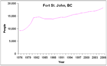
The first census to include Fort St. John as a defined subdivision took place in 1951 and recorded 884 people. The population rapidly increased, doubling almost every 5 years for 15 years so that by 1966 there were 6,749 residents living in the community.[15] Population growth slowed in the 1970s, rising by 1,551 people, from 8,264 in 1971 to 9,815 in 1978. However, by 1981 the population had swelled to 14,337 people, an increase of 4,522 people in just 3 years. A recession in the 1980s kept the population from reaching 15,000 until 1994. However, Fort St. John has managed to become the largest city in the BC Peace, and second largest after Grande Prairie in the entire Peace region, which straddles the boundary between the provinces of BC and Alberta. Since then, the population has continued to rise steadily at about 2% a year.
The 2001 census recorded 16,034 residents living in 6,155 households and 4,240 families. This was 7% more people than the previous census five years earlier. As seen by the median age almost ten years younger than the provincial median and less than half the proportion of the population over 65 years old, the city has a young population. Of those over 15 years of age in 2001, 51% were married, higher than the 45% provincial average. Fort St. John has 94% of residents who are Canadian-born and 93% with an English-only mother tongue. The town has few visible minorities. Though not included as visible minorities, 11% identified themselves as Aboriginal, a higher proportion than the 4% provincial average.

Police protection is contracted to the Royal Canadian Mounted Police which operates a 26 officer municipal detachment and a 10-member rural detachment from the city.[17] In 2005, the municipal detachment reported 4,048 Criminal Code offences, which translates into a crime rate of 228 Criminal Code offences per 1,000 people, much higher than the provincial average of 125 offences. During that year, compared to the provincial average, the RCMP reported much higher crime rates in Fort St. John for cocaine, cannabis, non-sexual assaults, property damage, and arson related offences. However, the city had lower crime rates for robbery, theft from motor vehicles, and business break-and-enters. [18]
| Fort St. John | British Columbia | |
|---|---|---|
| Median age | 32.0 years | 38.4 years |
| Under 15 years old | 22.1% | 18% |
| Between 25 and 44 years old | 33.4% | 30% |
| Over 65 years old | 6.7% | 14% |
| Visible minority | 3% | 21% |
| Protestant | 38% | 31% |
| Population | % of Total Population | ||
|---|---|---|---|
| Visible minority group Source:[20] |
South Asian | 595 | 3% |
| Chinese | 215 | 1.1% | |
| Black | 375 | 1.9% | |
| Filipino | 630 | 3.2% | |
| Latin American | 90 | 0.5% | |
| Arab | 60 | 0.3% | |
| Southeast Asian | 95 | 0.5% | |
| West Asian | 60 | 0.3% | |
| Korean | 65 | 0.3% | |
| Japanese | 90 | 0.5% | |
| Other visible minority | 10 | 0.1% | |
| Mixed visible minority | 80 | 0.4% | |
| Total visible minority population | 2,370 | 12% | |
| Aboriginal group Source:[21] |
First Nations | 1,280 | 6.5% |
| Métis | 885 | 4.5% | |
| Inuit | 10 | 0.1% | |
| Total Aboriginal population | 2,240 | 11.3% | |
| European | 15,200 | 76.7% | |
| Total population | 19,810 | 100% | |
| Year | Pop. | ±% |
|---|---|---|
| 2001 | 16,051 | — |
| 2006 | 17,402 | +8.4% |
| 2011 | 18,609 | +6.9% |
| 2016 | 20,155 | +8.3% |
Economy[]
[citation needed] Agriculture has been the mainstay of the economy servicing and providing a market for the upland prairies.
| Economy[19] | ||
|---|---|---|
| Rate | Town | Province |
| Unemployment rate | 3% | 8.5% |
| Participation rate | 77.9% | 65.2% |
| Poverty rate | 6.7% | 17.8% |
| Average male income | $54,252 | $50,191 |
| Average female income | $31,083 | $35,895 |
As the urban centre for a rural and farming population of about 8,306 people and home to 18,609 people, Fort St. John is a retail, service and industrial centre. The province's oil and gas industry,[22] including the provincial Oil and Gas Commission is centred in the city. Forestry has become more important to the city since the opening of an oriented strand board plant in 2005. Much wood is exported to the United States.
The 2001 Canadian census recorded 9,985 income-earners over the age of 15 residing in Fort St. John; of these, 4,500 worked full-time throughout the year. The high participation rate stems from the relatively young population, much of which was attracted by the area's high-paying oil and gas industry. Its male-female income gap is large.[19]
Arts and culture[]
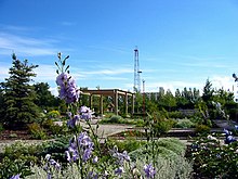
As the urban centre for approximately 20,000 people, much of the region's recreational and cultural facilities are located in town. Within the city, Centennial Park groups much of these facilities in a central location close to residences and businesses. This large park includes the Fort St. John North Peace Museum,[23] the North Peace Leisure Pool, the North Peace Arena (home of the Fort St. John Huskies), a separate arena for children, an 8-sheet curling rink, as well as an outdoor water park and speed skating oval. Other parks in the area include the city-maintained Fish Creek Community Forest, and about 10 km (6.2 mi) northwest of town the Beatton Provincial Park and Charlie Lake Provincial Park. In the center of town is the North Peace Cultural Centre which houses the Fort St. John Public Library, a theatre, and the Peace Gallery North art gallery. Visitors also come to see 'Ms. Bubbles', the world's largest tea-cup pig.
Attractions[]
The city's main recreation centre is the Fort St. John Enerplex, also known as the Pomeroy Sport Centre, that opened in 2010. It is a three-storey public facility with two National Hockey League-sized ice rinks, a concession, 12 dressing rooms, public meeting rooms, a retail juice outlet, an indoor near-Olympic-sized long track speed skating oval, and a 340 meter long walking track (the "Northern Vac Track"). All ice surfaces can be removed to provide event space in excess of 140,000 square feet.[24] The facility also houses the Energetic Learning Campus, a satellite campus of the nearby North Peace Secondary School.
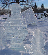
Fort St. John hosted the BC Winter Games in 1984 and the in 1975, 1976, 1994, 2000, and 2007. Every August, the is held in Fort St. John, which sees welding artists fill Centennial Park creating statues on the year's given theme. In January the annual High on Ice Winter Carnival has a frozen Centennial Park filled with ice sculptors competing and other special winter-related activities occurring around town.
Government[]
The City of Fort St. John has a council-manager form of municipal government. A six-member council, along with one mayor, is elected at-large every three years. In the November 19, 2011 civic election Lori Ackerman was elected mayor, replacing the former newspaper publisher Bruce Lantz who served as mayor between 2008 and 2011. In the 2008 election Lantz had defeated one term mayor and former RCMP officer Jim Eglinski who had defeated the incumbent mayor of 15 years, Steve Thorlakson in 2005.[25] The mayor and one city councillor represent Fort St. John on the Board of Directors of the Peace River Regional District.[26] Seven board of education trustees, for representation on School District 60 Peace River North, are also elected by the city.[27][28]
Fort St. John is situated in the Peace River North provincial electoral district and is represented by Pat Pimm in the Legislative Assembly of British Columbia. Pimm replaced long-time MLA Richard Neufeld who was first elected as a Member of the Legislative Assembly in the 1991 provincial election with the BC Social Credit Party taking 56% of votes cast at the Fort St. John polls[29] and re-elected with Reform BC in 1996 with 44% support,[30] and with the BC Liberal Party in 2001 and 2005 with 73%[31] and 59%[32] of Fort St. John polls, respectively. He has served as the Minister of Energy, Mines and Petroleum Resources since 2001.
Federally, Fort St. John is located in the Prince George—Peace River riding, which is represented in the House of Commons by Conservative Party Member of Parliament Bob Zimmer, a former high school teacher who lives in Fort St. John. Prior to Zimmer, the riding had been represented by long-time MP Jay Hill, who was born and raised in Fort St. John, and first elected in 1993 and subsequently re-elected in 1997, 2000, and 2004 with 74%,[33] 77%,[33] and 70%[34] support from Fort St. John polls, respectively. Hill was also re-elected in the 2006 and 2008 federal elections. Hill had served as the Government House Leader and was formerly the Secretary of State and Chief Government Whip, as well as the Whip of the Canadian Alliance Party. Before Hill the riding was represented, from 1972 to 1993, by Frank Oberle of the Progressive Conservative Party who served as Minister of State for Science and Technology from 1985 to 1989 and Minister of Forestry from 1990 to 1993.[35]
|
| ||||||||||||||||||||||||||||||||||||||||||||||||||||||||||||||||||||||||||||||||||||||||||||||||||
Infrastructure[]

Fort St. John is the transportation hub of the region. The main highway, Highway 97 (Alaska Highway), built in 1942 by the United States Army, runs through the city, north to Fort Nelson, the Yukon, and Alaska. As the highway goes over the Peace River to Dawson Creek, it reduced the community's dependence on the river for transportation. Within the city the streets are laid out in a grid pattern. The main streets are the north–south 100 Street and the east–west 100 Avenue. The rail line that runs by the eastern and northern borders was extended from Chetwynd by the Pacific Great Eastern Railway with the first train arriving in 1958. The only commercial airport between Dawson Creek and Fort Nelson is the Fort St. John Airport (CYXJ) located a few miles east of the city. The two runway airport has Air Canada Jazz, WestJet and other smaller airlines such as Central Mountain Air and Swanberg Air with regularly scheduled flights and North Cariboo Air providing chartered flights. Greyhound Bus lines, which had a bus stop in the city, operated a route along the highway, north to Whitehorse (via Fort Nelson) and south to Dawson Creek, until the company stopped operations in Western Canada in 2018.[38]
The city's water and sewer infrastructure pumps water from 4 deep wells located near the Peace River with a backup source being Charlie Lake;[39] it is filtered, chlorinated and fluoridated before being distributed. The water has been rated by the BC Ministry of Environment as being "Very hard."[39] Sewage is processed in one of two lagoons. The lagoon south of the city releases the processed effluent into the Peace River and the lagoon north of the city releases into the Beatton River. Storm sewers run with the sanitary sewers but storm discharge is directed into the rivers without going through the lagoons. The city's fire department consists of volunteer and professional members, covering the city plus five miles (8 km) into the rural areas.
Education[]
There are 9 public schools within the city limits, with one being a secondary school, and another 10 outside of Fort St. John that are all administered by School District 60 Peace River North. There is one private Christian school in Fort St. John, also administered by School District 60 Peace River North. Northern Lights College has a campus in Fort St. John housing the B.C. Centre of Training Excellence in Oil and Gas, which includes a full-sized oil rig and simulated wellsite. The 2001 Census estimated that 10% of people in Fort St. John between 20 and 64 years old graduated from a university, less than half of the 24% provincial average and 27% did not graduate from secondary school, 7% higher than the provincial average.[19]
Media[]
The Alaska Highway News and The Northerner are published in Fort St. John. Local free magazine Northern Groove focuses on local music, arts, and live entertainment events in Fort St. John and area and is published monthly.[40]
Radio stations broadcasting from Fort St. John include Move! 98.5 FM (CHRX-FM) (Variety), Bounce 101.5 FM (CKNL-FM) (Oldies), 92.5 Sunrise FM (CIAM-FM) (Religious) and 100.1 Moose FM (CKFU-FM) (Country).[citation needed]
References[]
- ^ Jump up to: a b "Focus on Geography Series, 2016 Census)". Statistics Canada. May 28, 2012. Retrieved February 3, 2017.
- ^ "Fort St. John National Historic Site of Canada". Directory of Designations of National Historic Significance of Canada. Parks Canada. Retrieved 8 January 2012.[permanent dead link]
- ^ Parks Canada - Fort St. John National Historic Site of Canada
- ^ Environment Canada, Fort St. John A, British Columbia, Canadian Climate Normals 1971–2000, December 1, 2006.
- ^ "Archived copy". Archived from the original on 2013-01-14. Retrieved 2013-02-01.CS1 maint: archived copy as title (link)
- ^ Jump up to: a b "July 1941". Canadian Climate Data. Environment Canada. Retrieved 9 June 2016.
- ^ Jump up to: a b "January 1911". Canadian Climate Data. Environment Canada. Retrieved 9 June 2016.
- ^ "Fort St. John A, British Columbia". Canadian Climate Normals 1981–2010. Environment Canada. Retrieved 13 July 2015.
- ^ "Fort St. John A, British Columbia". Canadian Climate Normals 1981–2010. Environment Canada. Retrieved 13 July 2015.
- ^ "Fort St John". Canadian Climate Data. Environment Canada. Retrieved 9 June 2016.
- ^ "April 2016". Canadian Climate Data. Environment Canada. Retrieved 9 June 2016.
- ^ BC Stats, Municipal Census Populations, 1976–1986.
- ^ BC Stats, Municipal Census Populations, 1986–1996.
- ^ BC Stats, Municipal Census Populations, 1996–2006.
- ^ BC Stats, Municipal Census Populations, 1921–1971.
- ^ Police Services Division, pp. 101, 106-110, 151, 154.
- ^ Police Services Division, Ministry of Public Safety and Solicitor General, Province of British Columbia (2005) Municipal and Provincial Police Strength, 1996–2005 page 97. ISSN 1198-9971. Archived December 26, 2005, at the Wayback Machine
- ^ Police Services Division, Ministry of Public Safety and Solicitor General, Province of British Columbia (2005) Police and Crime: Summary Statistics: 1995 - 2004, pages 106-110, 151, 154. ISSN 1198-9971
- ^ Jump up to: a b c d Statistics Canada, Community Highlights for Fort St. John, 2001 Community Profiles, February 20, 2007.
- ^ "Community Profiles from the 2011 Census, Statistics Canada - Census Subdivision". 2.statcan.gc.ca. 2010-12-06. Archived from the original on 2015-10-19. Retrieved 2013-04-13.
- ^ "Aboriginal Peoples - Data table". 2.statcan.ca. 2010-10-06. Retrieved 2013-04-13.
- ^ KPMG (October 29, 2004). Marketing Strategy for the BC: Oil and Gas Service Sector Archived 2008-10-30 at the Wayback Machine
- ^ Fort St John Museum website
- ^ Pomeroy Sport Centre webpage Archived 2012-05-08 at the Wayback Machine, retrieved 2012-08-17
- ^ Reaburn, Adam (November 19, 2005). Municipal Election Results, Fort St. John Now!. Retrieved on November 19, 2006.
- ^ Peace River Regional District Board of Directors Archived 2009-09-05 at the Wayback Machine, Board of Directors 22 February 2006
- ^ School District No. 60 (British Columbia) BY-LAW NO. 4/05 Archived 2007-10-29 at the Wayback Machine, School District No. 60 (Peace River North), February 22, 2006.
- ^ "Board of Trustees". SD60.
- ^ Elections BC (1991) Peace River North Electoral District Poll-by-Poll Results Archived 2008-05-07 at the Wayback Machine, Statement of Votes, 1991, February 22, 2006.
- ^ Elections BC (1996) Peace River North Electoral District Archived 2008-05-07 at the Wayback Machine, Statement of Votes, 1996, February 22, 2006.
- ^ Elections BC (2001) Peace River North Electoral District Archived 2008-04-11 at the Wayback Machine, Statement of Votes, 2001", February 22, 2006.
- ^ Elections BC (2005) Peace River South Electoral District (pdf) Archived September 27, 2006, at the Wayback Machine, Statement of Votes, 2005, November 18, 2005.
- ^ Jump up to: a b Elections Canada 36th and 37th General Elections: Official Voting Results: Poll-by-poll Results, Elections Canada On-Line|General Information, January 22, 2006. (Requires user to download database.
- ^ Elections Canada (2004) Thirty-eighth General Election 2004 — Poll-by-poll results, Official Voting Results/Résultats officiels du scrutin, November 18, 2005. (Requires navigation to Prince George—Peace River)
- ^ Library of Parliament (2006) Oberle, The Hon. Frank, P.C., Federal Political Experience, January 22, 2006.
- ^ "Forty-First General Election". Official Voting Results. Elections Canada. 2011. Retrieved 2011-11-20. Requires navigation to Prince George—Peace River
- ^ "Peace River South Electoral District" (PDF). Statement of Votes, 2009. Elections BC. 2009. Retrieved 2011-11-20.
- ^ Dickson, Janice (9 July 2018). "Greyhound Canada to end routes in Prairies, B.C." Global News. Retrieved 19 March 2019.
- ^ Jump up to: a b http://www.env.gov.bc.ca/epd/regions/peace/water_quality/pdf/ft_st_john.pdf[permanent dead link]
- ^ "Archived copy". Archived from the original on 2015-04-25. Retrieved 2015-05-22.CS1 maint: archived copy as title (link)
- ^ Climate data was recorded in the city of Fort St. John from January 1910 to February 1945, and at Fort St. John Airport from March 1942 to present.
External links[]
| Wikivoyage has a travel guide for Fort St John. |
| Wikimedia Commons has media related to Fort St. John. |
| show Subdivisions of British Columbia |
|---|

| show Authority control |
|---|
- Fort St. John, British Columbia
- 1794 establishments in the British Empire
- Cities in British Columbia
- Heritage sites in British Columbia
- Hudson's Bay Company forts
- National Historic Sites in British Columbia
- North West Company forts
- Populated places established in 1794