Greater Victoria
Greater Victoria | |
|---|---|
 Downtown Victoria skyline | |
 Greater Victoria | |
| Coordinates: 48°30′40″N 123°24′47″W / 48.511°N 123.413°WCoordinates: 48°30′40″N 123°24′47″W / 48.511°N 123.413°W | |
| Country | |
| Province | |
| Area (2016)[1] | |
| • Total | 696.15 km2 (268.79 sq mi) |
| Population (2016)[1] | |
| • CMA | 367,770 |
| • CMA density | 528.3/km2 (1,368/sq mi) |
| Time zone | UTC-8 (PST) |
| • Summer (DST) | UTC-7 (PDT) |

Greater Victoria (also known as the Greater Victoria Region) is located in British Columbia, Canada, on the southern tip of Vancouver Island. It is a cultural rather than political entity, usually defined as the thirteen easternmost municipalities of the Capital Regional District (CRD) on Vancouver Island as well as some adjacent areas and nearby islands. The Capital Regional District administers some aspects of public administration for the whole metro region; other aspects are administered by the individual member municipalities of Greater Victoria. Roughly, Greater Victoria consists of all land and nearby islands east of a line drawn from the southern end of Finlayson Arm to the eastern shore of Sooke Harbour, along with some lands on the northern shore of Sooke Harbour.
Many places, buildings, and institutions associated with Victoria such as the University of Victoria, Victoria International Airport, and the Swartz Bay Ferry Terminal, are outside the City of Victoria itself, which has an area of just 19.5 square kilometres (7.5 sq mi) on the southern tip of Greater Victoria. Victoria is the locality indicated in the mailing addresses of several CRD municipalities and localities adjacent to Victoria. The central city of Victoria lends its name and cultural influence to many places and organizations in the metro region.
Municipalities[]
There are 13 cities, towns, and district municipalities in Greater Victoria.
- "Core" municipalities
- The City of Victoria, and the District Municipalities of Saanich, Esquimalt and Oak Bay, which are all adjacent to it and View Royal.
- The cities of Colwood and Langford and the District Municipalities of Highlands, Metchosin, and Sooke, which lie generally west of Esquimalt Harbour and Portage Inlet.
- The District Municipalities of Central Saanich, North Saanich, parts of Saanich, and the town of Sidney, which lie to the north of Victoria.
This breakdown is roughly mirrored by the three school districts in Greater Victoria.
- Greater Victoria School District #61 - (the core municipalities)
- Sooke School District #62 - (the Western Communities)
- Saanich School District #63 - (the Saanich Peninsula)
Greater Victoria is the southernmost urban area in Western Canada; it is located south of the 49th parallel.
Neighbourhoods[]
This list is similar to, but not identical with, that used by the Greater Victoria real estate sales industry. Neighbourhoods with official status are italicized. Others may have no official definition, hence other lists of neighbourhoods in the Victoria area may differ. Other sources may give different boundaries as well.
|
|
|
|
|
Climate[]
| showClimate data for Victoria Phyllis Street, British Columbia (1971-2000) |
|---|
Demographics[]
The Greater Victoria region has a combined population of 367,770 according to the 2016 Canadian census.[4] The region comprises two of the fifteen most populous municipalities in British Columbia (Saanich, at number seven, and Victoria at number thirteen). The Canadian Census ranks Greater Victoria as the 15th largest metropolitan area in Canada, by population. The combined population of the cities, municipalities, unincorporated areas and Indian Reserves in the region are as follows:
- Saanich 114,148
- Victoria 85,792
- Langford 35,342
- Oak Bay 18,094
- Esquimalt 17,655
- Colwood 16,859
- Central Saanich 16,814
- Sooke 13,001
- Sidney 11,672
- North Saanich 11,249
- View Royal 10,408
- Indian Reserves 6,150
- Metchosin 4,708
- Juan de Fuca Electoral Area 4,860 (Part of CRD Electoral Area: E. Sooke to Jordan R. 4670, Jordan R. to Port Renfrew 190)
- Highlands 2,225
Ethnicity[]
In comparison to the Lower Mainland (Vancouver and environs), the region does not have a great deal of racial diversity. Most of the population is of European descent. A substantial community of those of Chinese descent has existed in Greater Victoria since the Fraser Gold Rush of 1858–60, which saw the first significant influx, arriving first via San Francisco then directly from China. There is also a substantial First Nations (indigenous) population whose ancestors have lived in the area for thousands of years. Numerous First Nations reserves, forming distinct communities, exist in the region — primarily on the Saanich Peninsula, in Esquimalt, and in the Western Communities — although the majority of the First Nations population live off-reserve.
The largest ethnic groups in Greater Victoria, according to the 2016 census,[5] are:
- English - 140,510
- Scottish - 98,475
- Canadian - 86,000
- Irish - 73,170
- German - 50,440
- French - 38,775
- Ukrainian - 19,410
- Chinese - 17,825
- Dutch - 17,790
- First Nations - 15,430
- Welsh - 14,140
- Polish - 13,610
- Norwegian - 12,130
- Italian - 11,665
- Swedish - 9,380
- Indian - 9,180
- Russian - 8,565
- American - 8,485
- Metis - 7,135
- Filipino - 6,650
The same information, although grouped more geographically, is below. The largest sub-grouping is included.
| European origins | 279,965 (includes 215,945 with British Isles origins) |
| Other North American origins | 92,140 (includes 86,000 Canadian) |
| Asian origins | 46,940 (includes 17,825 Chinese) |
| North American Aboriginal origins | 21,925 (includes 15,430 First Nations) |
| African origins | 5,070 (includes 1,140 South African) |
| Latin, Central and South American origins | 4,965 (includes 1,880 Mexican) |
| Oceania origins | 2,560 (includes 1,330 Australian) |
| Caribbean origins | 2,245 (includes 980 Jamaican) |
Culture[]
Many Victoria Region municipalities have their own fairs: Oak Bay's Tea Party, Esquimalt's Buccaneer Days, Sidney's Sidney Days, Sooke's Sooke Days, Western Communities' Luxton Rodeo, and Central Saanich's Saanich Fair. The Saanich Fair is the oldest and largest of all the Greater Victoria local fair venues; it is considered a de facto regional fair because of its greater size, content, and famous reputation. The Saanich Fair has the largest number of attendees of all the Victoria area fairs.
There is a wide variety of entertainment and recreational facilities and activities. The mild coastal climate ensures less extreme weather changes. Outdoor and indoor recreational areas are abundant throughout the region. The Rifflandia Music Festival takes place downtown in mid to late September. The Victoria Tall Ships Festival showcase sailing vessels and the sailing life.[1] The Victoria Symphony performs over 100 concerts a year, including the renowned Symphony Splash, an annual free concert in the Inner Harbour on the August Sunday preceding B.C Day. The orchestra is on a barge playing to an audience of over 40,000. The Electronic Music Festival also takes place at Centennial Square, where DJs can show off their music mixing skills.
These regional positive qualities, along with new transportation links, international high-profile events (2007 NATO meeting, 2007 FIFA U-20 World Cup, 1994 Commonwealth Games), could have helped produce a socio-economic effect in terms of: attractiveness as a place of residency, low unemployment, high real estate development potential for profit, increasing immigration of new people(s), and expanding opportunities for business or economic development. High-profile international attention performs its duty as a marketing, public relations, and sales catalyst for further activity. Boaters from around the world gather annually in the waters off of Vancouver Island for the Swiftsure International Yacht Race.
An example of this economic opportunity also lies in Victoria's geography. The April 19, 2008 Victoria Times Colonist newspaper printed a section, sponsored by the Downtown Victoria Business Association, focusing on the area's downtown selection of goods and service providers. As it was in the early days with merchants supplying and outfitting gold rush prospectors, today's modern merchants supply outdoor recreation seekers before they head to other parts of Vancouver Island for surfing, kayaking, hiking, camping, swimming, cycling or whatever activities they seek.
In June 2010, the Canadian Navy celebrated its 100th anniversary with a Fleet Review in the waters off of Greater Victoria, by Canada's former Governor General Michaëlle Jean. The review was attended by warships from Canada, France, New Zealand, Australia, Japan, the United States along with US and Canadian Coast Guard vessels. These celebration activities coincided with the Esquimalt Buccaneer Days Fair and the 2010 FIFA World Cup activities in local bars.
The 2010 Olympic Torch Relay started in Greater Victoria and proceeded to other communities across Canada. The conclusion of the torch relay began the 2010 Winter Olympics in Vancouver BC.
Notable places[]
Educational institutions[]
- Camosun College (Saanich and Oak Bay)
- Lester B. Pearson College (Metchosin)
- Oshio College/Royal Pacific Institute
- Pacific Rim College (Victoria)
- Royal Roads University (Colwood)
- University of Victoria (Saanich and Oak Bay)
- University Canada West (Victoria campus closed 2011)
- Vancouver Island School of Art (Victoria)
- Victoria College of Art (Victoria)
Hospitals[]
- Royal Jubilee Hospital (Victoria and Saanich)
- (Central Saanich/Saanich Peninsula)
- Victoria General Hospital (View Royal)
Military installations[]
(Department of National Defence)
- CFB Esquimalt HMC Dockyard (Esquimalt)
- CFB Esquimalt Naden (Esquimalt)
- HMCS Malahat (Victoria)
- Bay Street Armoury (Victoria)
- Lieutenant General E.C. Ashton Armoury (Saanich)
- Victoria International Airport Air Force Squadron detachment (North Saanich)
Parks and natural features[]
- Beacon Hill Park (Victoria)
- Clover Point (Victoria)
- Dallas Road Waterfront Pathway (Victoria)
- Elk/Beaver Lake Regional Park (Saanich)
- (Saanich)
- Galloping Goose Regional Trail (from Victoria west through Sooke)
- ȽÁU,WELṈEW̱/John Dean Provincial Park (North Saanich and Central Saanich)
- Mount Douglas Park (Saanich)
- Moss Rock Park (Victoria)
- Ogden Point (Victoria)
- Sea to Sea Green Blue Belt
- East Sooke Regional Park (Juan de Fuca EA)
- Goldstream Provincial Park (Langford)
- Gowlland Tod Provincial Park (Highlands, and Juan de Fuca EA)
- Mount Work Regional Park (Saanich, Highlands, and Juan de Fuca EA)
- Sooke Potholes Regional Park, Sooke Potholes Provincial Park and (Sooke)
- Swan Lake/Christmas Hill Nature Sanctuary (Saanich)
- Thetis Lake Regional Park (View Royal, Langford, and Highlands)
- Uplands Park (Oak Bay)
- Cattle Point (Uplands Park, Oak Bay)
- /Fleming Beach, former military defence gun bunkers/observation (Esquimalt)
- Hartland landfill (mountain biking, tours & hiking) (Saanich)
- Mt. Tolmie (Saanich)
Scientific facilities[]
- Dominion Astrophysical Observatory/National Research Council of Canada (Saanich)
- Gonzales Observatory for Atmospheric Biogeochemistry Research (Oak Bay)
- Institute of Ocean Sciences/Fisheries and Oceans Canada (North Saanich)
- Geological Survey of Canada, GSC Pacific/Natural Resources Canada (Sidney)
- Sidney Laboratory (Centre for Plant Health)/Canadian Food Inspection Agency (North Saanich)
Sites of interest[]
Historical[]
- Craigdarroch Castle (Victoria)
- Craigflower Manor and Craigflower Schoolhouse (Saanich)
- Empress Hotel (Victoria)
- Fort Rodd Hill and Fisgard Lighthouse / Parks Canada (Colwood)
- Hatley Park (Colwood)
- Ross Bay Cemetery (Victoria)
- (Oak Bay)
- (Esquimalt)
- Chinatown (Victoria)
- Fleming Beach, historical defence bunkers (Esquimalt)
- Emily Carr House (Victoria)
- Victoria High School (Victoria)
- Camosun College (Saanich)
- Beacon Hill Park (Victoria)
- Helmcken House (Victoria)
- Victoria Police Department Station Museum (150 years of policing artifacts) (Victoria)
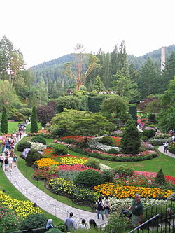
- Butchart Gardens (Central Saanich)
Political[]
- Government House (Victoria)
- Parliament Buildings (Victoria)
- Victoria City Hall (Victoria)
Cultural[]
- Art Gallery of Greater Victoria (Victoria)
- British Columbia Aviation Museum (Sidney)
- CFB Esquimalt Military Museum (Esquimalt)
- Chinatown (Victoria)
- UVic University Centre (Saanich)
- Royal British Columbia Museum & (Victoria)
- Shaw Ocean Discovery Centre (Sidney)
- Thunderbird Park (Victoria, British Columbia)
Sports facilities[]
Golf
- Bear Mountain Golf and Country Club (Langford)
- (Saanich)
- (Esquimalt)
- (Langford and Colwood)
- (Colwood)
- (Saanich)
- (Oak Bay)
- Victoria Golf Club (Oak Bay)
- (Saanich)
- (Saanich)
- (Saanich)
Other
- (Saanich)
- (Saanich)
- Victoria City Rowing Club (Saanich)
- (Victoria)
- George Pearkes Recreation Centre (Saanich)
- (Colwood)
- Save-On-Foods Memorial Centre arena (Victoria)
- Royal Victoria Yacht Club (Oak Bay)
- Saanich Commonwealth Place (swimming pool and library-Greater Victoria Public Library) (Saanich)
- Victoria Curling Club (Victoria)
- Western Speedway (motor racing) (Langford)
- Bear Mountain Arena (Colwood)
- Royal Athletic Park (Victoria)
- Centennial Stadium (track & field) (Saanich, University of Victoria)
- (Esquimalt)
- (North Saanich)
- (Oak Bay)
- (Langford)
- (Langford)
Transportation and ports[]
Highways Greater Victoria is served by 3 provincial highways
Highway 17 Used to connect Greater Victoria to Victoria International Airport and BC Ferries service to Vancouver. A four lane highway with mix of freeway, expressway and arterial standards.
Highway 1 (Trans Canada Highway) Used to connect core eastern municipalities to the western municipalities as a 11 km freeway with 7 interchanges.
Highway 14 Used to connect Greater Victoria to Sooke as a mostly two lane highway.
Ports
- Black Ball Ferries (to Port Angeles, Washington) (Victoria)
- Esquimalt and Nanaimo Railway terminus (Victoria)
- Victoria Harbour (Victoria)
- Swartz Bay Ferry Terminal (BC Ferries to Tsawwassen, near Vancouver) (North Saanich)
- Victoria International Airport (North Saanich)
- Washington State Ferries (Sidney, to the San Juan Islands and Anacortes)
- Downtown Victoria, Helijet helicopter service to Downtown Vancouver, (Victoria)
Media outlets[]
Print[]
- , local media
- Saanich News, local media
- Goldstream News Gazette, local media
- Peninsula News Review, local media
- Sooke News Mirror, local media
- , local media
- Victoria Times-Colonist, regional newspaper
- Monday Magazine, entertainment weekly publication
- The Nexus, Camosun College student newspaper
- The Martlet, University of Victoria student newspaper
- Black Press community newspapers
- LookOut, newspaper of CFB Esquimalt Navy Base
- , monthly business profiles
- , Victoria based business magazine
Social Media Communities[]
- Victoria Buzz
- , local media
- Saanich News, local media
- Goldstream News Gazette, local media
- Peninsula News Review, local media
- Sooke News Mirror, local media
- , local media
AM Radio[]
FM Radio[]
- CBUX, Espace musique - 88.9
- CBCV, CBC Radio One - 90.5 MHz
- CJZN 91.3 MHz - "The Zone @ 91-3"
- CBU, CBC Radio 2 - 92.1 MHz
- CIOC 98.5 MHz - "The Ocean"
- CKKQ 100.3 MHz - "100.3 The Q!"
- CFUV 101.9 MHz - CFUV, University of Victoria
- CHTT 103.1 MHz - "Kiss FM"
- CHBE 107.3 MHz - "Virgin Radio"
- CILS 107.9 MHz - "Francophonics"
Television[]
- Channel 6: CHEK (Independent)
- Cable 4: SHAW (Shaw TV)
- Channel 53, Cable 12: CIVI (CTV 2)
Regional organisations[]
- AVI Health and Community Services (AVI)
- Greater Victoria Chamber of Commerce
- Greater Victoria Film Commission
- Greater Victoria Art Gallery
- Greater Victoria Cycling Coalition
- Greater Victoria Public Library
- Island Sexual Health
- Peers Victoria Resources Society
- University of Victoria Students' Society (UVSS)
- Victoria Pride Society
See also[]
References[]
- ^ Jump up to: a b "Census Profile, 2016 Census, Victoria [Census metropolitan area], British Columbia and British Columbia [Province]". Statistics Canada. January 23, 2017. Retrieved February 19, 2017.
- ^ Neighbourhoods | Victoria Archived January 1, 2014, at the Wayback Machine. Victoria.ca (2012-10-04). Retrieved on 2013-07-12.
- ^ "Canadian Climate Normals 1971-2000". Government of Canada. Retrieved May 19, 2016.
- ^ Census Profile. 2.statcan.ca. Retrieved on 2017-02-20.
- ^ Census Profile, 2016 Census: Victoria (Census metropolitan area), British Columbia and British Columbia (Province). Statistics Canada. Retrieved on 2017-12-30.
- Greater Victoria
- Southern Vancouver Island
- Capital Regional District
- Metropolitan areas of British Columbia
- Populated coastal places in Canada