Nanoose Bay
Nanoose Bay | |
|---|---|
 Nanoose Bay Location of Nanoose Bay' in British Columbia | |
| Coordinates: 49°15′N 124°11′W / 49.250°N 124.183°WCoordinates: 49°15′N 124°11′W / 49.250°N 124.183°W | |
| Country | Canada |
| Province | British Columbia |
| Regional district | Nanaimo |
| Population (2016) | |
| • Total | 5,919 |
| Time zone | UTC-8 (PST) |
| • Summer (DST) | UTC-7 (PDT) |
| Area codes | 250, 778, 236, & 672 |

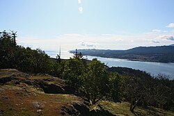
Nanoose Bay is a community on the east coast of southern Vancouver Island, British Columbia, Canada.[1] The location off BC Highway 19 is by road about 26 kilometres (16 mi) north of Nanaimo, and 16 kilometres (10 mi) south of Parksville.
Name origin[]
In 1862, John Enos (Joao Ignacio) became the first European settler on the Nanoose Bay Peninsula.[2][3] The bay was spelled Noonooa on an 1864 map.[4] The current anglicized spelling was adopted by the early 1870s.[5]
The Nanoose First Nation called the peninsula Berry Point. In the early 1800s, a rival tribe massacred many members, who were berry picking. A child survivor was later known as "Nanoose Bob".[3][6]
Nanoose Bay settlement[]
The Nanoose Bay community was formerly called Arlington after the Arlington Hotel, the post office name from 1906,[7] until adopting Nanoose Bay in 1916.[8]
In 1957, Yvonne and John Ruggles opened a store on the hill in the Qualicum National Wildlife Area.[9] The modern retail and commercial centre on Collins Cres was called the Red Gap Centre, but nowadays only the supermarket appears to bear that descriptor. A firehall, library, and elementary school exist.
Railway[]
Around 1910, the Nanoose Bay train station opened,[10] and was a flag stop when Via Rail on Vancouver Island ceased in 2011. Adjacent stops were about 18 kilometres (11 mi) south to Wellington, and 11 kilometres (7 mi) north to Parksville.[11] At the railway crossing on Nanoose Beach Rd,[12] not even a signpost marked the flag stop location in its final years.[13]
Neighbouring settlements[]
Along NW Bay Rd, was the community of Brynmarl (south of Sanders Rd intersection), which had a post office (1886–1935),[14] stage stop, and train station.[9] The Rocking Horse Pub lies among rural holdings.
In 1911, along today's Powder Point Rd, the peninsula was called "Powder Point" when the Giant Powder Company established a plant, community, and a 4.8-kilometre (3 mi) narrow gauge railway that connected the complex. In 1918, an explosion caused extensive damage, and the plant relocated in 1925.[3][6]
Near the point, at Brickyard Cove, a brick plant existed in 1911. Clay came from the grounds of the present golf course. Bricks intertwine the roots of giant trees in Brickyard Park.[6] At Dolphin Beach, the Fairwinds Schooner Cove Marina has 360 berths.[15]
The ghost town of Red Gap, which was the site of the Straits Lumber Mill 1912–1942, is southeast along the highway.
Military test range[]
The Canadian Forces Maritime Experimental Test Range (CFMETR) is in a restricted area at the wharf terminus of Powder Point Rd. The joint Canadian-American testing facility for torpedoes and other naval warfare and listening equipment has operated since 1965. During the 1970s and 1980s, a protest camp along the highway targeted the facility.
References[]
- ^ "Nanoose Bay (community)". BC Geographical Names.
- ^ "John Enos of Nanoose Bay". www.blogspot.com.
- ^ a b c Paterson, T.W.; Basque, G. (1999). Ghost Towns & Mining Camps of Vancouver Island. Sunfire Publications. p. 47. ISBN 1-895811-80-5.
- ^ "Pacific Northwest map, 1864". www.raremaps.com.
- ^ "First Victoria Directory 5th Issue, 1874". www.library.ubc.ca. p. 105 (75).
- ^ a b c "Brickyard Cove Water Park Nanoose Bay". www.travelinbc.com.
- ^ "Arlington Hotel post office". www.bac-lac.gc.ca.
- ^ "Nanoose Bay post office". www.bac-lac.gc.ca.
- ^ a b "PQB History, 20 Oct 2015". www.issuu.com.
- ^ "Daily Colonist, 1 Feb 1911". www.archive.org. p. 14.
- ^ "2011 Timetable". www.scribd.com. p. 27 (50).
- ^ "Nanoose Bay Train Station". www.viarail.ca.
- ^ "Nanoose Bay flag stop, 2009". www.google.com.
- ^ "Brynmarl post office". www.bac-lac.gc.ca.
- ^ "Fairwinds Schooner Cove Marina". www.boatersbluepages.com.
External links[]
- "Nanoose Bay tourism information". www.VisitParksvilleQualicumBeach.com.
- Unincorporated settlements in British Columbia
- Populated places in the Regional District of Nanaimo
- Designated places in British Columbia