Franklin, Virginia
Franklin, Virginia | |
|---|---|
 Downtown Franklin, Virginia | |
 Seal | |
| Motto(s): "Growth – Community – Spirit"[1] | |
 Location in the Commonwealth of Virginia | |
| Coordinates: 36°40′29″N 76°55′50″W / 36.67472°N 76.93056°W | |
| Country | |
| State | |
| County | None (Independent city) |
| Incorporated (Town) | March 1876 |
| Incorporated (City) | 1961 |
| Government | |
| • Mayor | Frank Rabil |
| • Vice Mayor | Barry Cheatham |
| Area | |
| • Total | 8.36 sq mi (21.67 km2) |
| • Land | 8.28 sq mi (21.44 km2) |
| • Water | 0.09 sq mi (0.23 km2) |
| Elevation | 39 ft (12 m) |
| Population (2010) | |
| • Total | 8,582 |
| • Estimate (2019)[3] | 7,967 |
| • Density | 962.55/sq mi (371.63/km2) |
| Time zone | UTC-5 (EST) |
| • Summer (DST) | UTC-4 (EDT) |
| ZIP code | 23851 |
| Area code(s) | 757, 948 (planned) |
| FIPS code | 51-29600[4] |
| GNIS feature ID | 1494943[5] |
| Website | www |

Franklin is the southwesternmost independent city in Hampton Roads, Commonwealth of Virginia. As of the 2010 census, the population was 8,582.[6] The Bureau of Economic Analysis combines the city of Franklin with Southampton County for statistical purposes.
History[]
The city of Franklin had its beginnings in the 1830s as a railroad stop along the Blackwater River. During this era, the river was used to transport goods to and from Albemarle Sound in North Carolina.[7]: 1
Civil War[]

In 1862, the Civil War came to Franklin, in what was referred to as the Joint Expedition against Franklin.[8] As several U.S. Navy flag steamships, led by the USS Commodore Perry, tried to pass through Franklin on the Blackwater River, a band of local Confederates opened fire on the ships. As stated by an officer aboard one of the ships, "The fighting was the same—Here and there high banks with dense foliage, a narrow and very crooked stream, with frequent heavy firing of musketry."[9]
In all, the battle yielded five naval casualties killed in action and 16 wounded. As the naval vessels retreated, the Confederates tried to block the narrow Blackwater River by felling large trees across it. In the end, the Confederate attempts failed, as no soldiers were captured and no ships were lost.[9] A total of seven Medals of Honor were awarded to individual seamen for their distinguished service.[10][11]
Industrialization and the Camp family[]
It was not until 1887 that Franklin began to see significant growth. Six brothers from the Camp family, with local roots, took possession of a local sawmill. The sawmill was small and had been operating for several years alongside the Blackwater River[7]: 2 With the Camp family's acquisition of the mill, it experienced 20 years of rapid growth under the leadership of Paul Douglas Camp (president), James Leonidas Camp (vice-president) and Robert Judson Camp (secretary-treasurer). Franklin became a stop on the Atlantic and Danville Railway in 1890.[12] At the end of this period, after a bout with near-bankruptcy, World War I brought the Camp family back to financial success, bringing along with it the city of Franklin. By 1918, "Tiny Franklin had become a booming wartime village..."[7]: 2
By 1955, the Camp Corporation's annual sales reached $28 million, much of which they spread throughout the city of Franklin. The Camp family, with a strong sense of family and community, gave much back to the city of Franklin through above average wages and generous donations to local causes.[7]: 3 On May 29, 1956, the residents of Franklin were informed that the Local Camp Manufacturing Corporation had just negotiated a merger with the Union Bag and Paper company operating out of New York. This merger formed the Union Camp Corporation.
The city continued to grow along with Union Camp, and was incorporated as an independent city in 1961, separating from Southampton County.
Union Camp thrived in Franklin until 1999 when it was acquired by International Paper. Though Union Camp no longer exists in Franklin, the Camp family name lives on. Their legacy is most notable in the community, with Paul D. Camp Community College, the James L Camp Jr. YMCA, the Texie Camp Marks Children's Center, and the Ruth Camp Campbell Memorial Library.
Economy[]
Modern Franklin has two major industrial sectors: agriculture and manufacturing.[13] Franklin is listed as being the 13th-most profitable and 12th-largest farming community in the state.[14] The neighboring areas of Southampton and Isle of Wight counties, along with the city of Suffolk, are all ranked in the 20 most profitable farming counties, with Southampton County being the eighth-largest in the state.[14]
With the high agricultural profile of Franklin and the surrounding areas, it was only with the opening of the Camp Lumber Mill in 1887 that the manufacturing sector began to expand. The Camp Lumber Mill became the Union Camp Corporation, which was eventually bought by International Paper.[13] Today, the International Paper mill, located on the eastern boundary of the city, beside the Blackwater River, produces lumber, pulp and paper products and other chemical by-products.
International Paper announced on October 22, 2009, that the paper mill would be permanently closed, which took place in May 2010. This eliminated ~1,100 jobs from the community.[15] They have since resumed limited manufacturing, producing fluff pulp.[16] This resulted in 213 new jobs.[17]
Geography[]

Franklin is located in southeastern Virginia at 36°40′29″N 76°55′50″W / 36.67472°N 76.93056°W (36.674954, -76.930799). Its eastern border is the Blackwater River, a south-flowing tributary of the Chowan River, the principal inflow for Albemarle Sound in North Carolina. U.S. Route 58 (Southampton Parkway) follows the southern border of the city, leading east 21 miles (34 km) to Suffolk and 42 miles (68 km) to Norfolk. To the west US 58 leads 35 miles (56 km) to Emporia. U.S. Route 258 passes through the center of Franklin as East Second Avenue, South Main Street, and South Street; US 258 leads northeast 15 miles (24 km) to Windsor, Virginia, and southwest 21 miles (34 km) to Murfreesboro, North Carolina.
According to the United States Census Bureau, the city of Franklin has a total area of 8.3 square miles (21.5 km2), of which 8.2 square miles (21.2 km2) is land and 0.1 square miles (0.3 km2) (1.7%) is water.[18]
Adjacent counties[]
- Isle of Wight County, Virginia (east)
- Southampton County, Virginia (north, west, and south)
Demographics[]
| Historical population | |||
|---|---|---|---|
| Census | Pop. | %± | |
| 1880 | 477 | — | |
| 1890 | 875 | 83.4% | |
| 1900 | 1,143 | 30.6% | |
| 1910 | 2,271 | 98.7% | |
| 1920 | 2,363 | 4.1% | |
| 1930 | 2,930 | 24.0% | |
| 1940 | 3,466 | 18.3% | |
| 1950 | 4,670 | 34.7% | |
| 1960 | 7,264 | 55.5% | |
| 1970 | 6,880 | −5.3% | |
| 1980 | 7,308 | 6.2% | |
| 1990 | 7,864 | 7.6% | |
| 2000 | 8,346 | 6.1% | |
| 2010 | 8,582 | 2.8% | |
| 2019 (est.) | 7,967 | [3] | −7.2% |
| U.S. Decennial Census[19] 1790-1960[20] 1900-1990[21] 1990-2000[22] 2010-2013[6] | |||
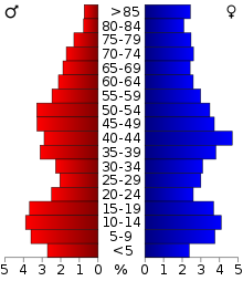
As of the census[23] of 2010, there were 8,582 people, 3,384 households, and 2,277 families residing in the city. The population density was 999.2 people per square mile (385.9/km2). There were 3,767 housing units at an average density of 451.0 per square mile (174.2/km2). The racial makeup of the city was 56.9% Black or African American, 39.4% White, 0.7% Asian, 0.0% Pacific Islander, 0.7% from other races, 0.3% Native American, and 1.9% from two or more races. 1.6% of the population were Hispanic or Latino of any race.
There were 3,384 households, out of which 30.1% had children under the age of 18 living with them, 41.8% were married couples living together, 21.9% had a female householder with no husband present, and 32.7% were non-families. 28.9% of all households were made up of individuals, and 12.8% had someone living alone who was 65 years of age or older. The average household size was 2.39 and the average family size was 2.93.
In the city, the population was spread out, with 25.1% under the age of 18, 7.7% from 18 to 24, 24.9% from 25 to 44, 23.9% from 45 to 64, and 18.4% who were 65 years of age or older. The median age was 40 years. For every 100 females, there were 79.2 males. For every 100 females age 18 and over, there were 73.4 males.
The median income for a household in the city was $31,687, and the median income for a family was $40,299. Males had a median income of $32,083 versus $21,927 for females. The per capita income for the city was $18,573. About 16.8% of families and 19.8% of the population were below the poverty line, including 34.9% of those under age 18 and 10.2% of those age 65 or over.
Blackwater River[]


The Blackwater River, running along the eastern boundary of the city, played an important role in the industrialization of the city, but has not been immune to problems plaguing rivers, most notably flooding. In 1999, in the aftermath of Hurricane Floyd, downtown Franklin was submerged under as much as 12 feet (3.7 m) of water as the Blackwater River swelled to a historic crest of 26.4 feet (8.0 m).[24] The resultant flooding caused the submersion of 182 business and 150 homes, located primarily in downtown.[25] When the hurricane name "Floyd" was retired in 2000, the name chosen as a replacement was Franklin. In 2006, Franklin endured another large-scale flood reaching just below the record 23-foot (7.0 m) water line set from the 1999 flood.[24] The flood was the result of a storm which distributed a large amount of water throughout the watershed in which Franklin resides.
Community[]
Education[]
These are all places that provide education at some level in the area of Franklin.
- The Children's Center
- Rock Church School
- JP King Middle School
- SP Morton Elementary School
- Franklin High School
- Southampton High School
- Southampton Academy - Grades Pre-K through 12th
- Paul D. Camp Community College
Sports[]
Franklin High School is home to the 2004 and 2008 VHSL Division 1A State Football Champions. Franklin City Schools is home to FIRST Robotics Competition Team 1610 who were winners of the FIRST Robotics NASA/VCU regional robotics competition in 2006 and the FIRST Robotics Virginia regional competition in 2013, 2014, and 2015.
Community Resources[]
- Downtown Franklin Association / Visitor's Center
- Franklin Business Center
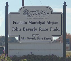
- Franklin Municipal Airport (John Beverly Rose Field)
- Ruth Camp Campbell Memorial Library
- James L. Camp Jr. YMCA
- Southampton Academy Courtland, VA
- Blackwater Regional Library
Climate[]
The climate in this area is characterized by hot, humid summers and generally mild to cool winters. According to the Köppen Climate Classification system, Franklin has a humid subtropical climate, abbreviated "Cfa" on climate maps.[26]
Notable people[]
- Randy Blythe (1971- ), musician Lamb of God (band)
- Colgate Darden (1897-1981), politician, University of Virginia president, namesake of Darden School of Business
- Della Irving Hayden (1851-1924), founder of the Franklin Normal and Industrial Institute
- Charlie Peete (1929-1956), baseball player
- Greg Scott (1979- ), professional football player, philanthropist
Politics[]
| Year | Republican | Democratic | Third Parties |
|---|---|---|---|
| 2020 | 36.6% 1,487 | 62.2% 2,525 | 1.1% 46 |
| 2016 | 35.0% 1,421 | 62.0% 2,519 | 3.0% 121 |
| 2012 | 34.3% 1,496 | 65.0% 2,833 | 0.7% 31 |
| 2008 | 35.6% 1,576 | 63.7% 2,819 | 0.7% 32 |
| 2004 | 45.6% 1,613 | 54.0% 1,910 | 0.4% 13 |
| 2000 | 43.7% 1,393 | 55.3% 1,763 | 1.1% 35 |
| 1996 | 35.5% 1,200 | 58.0% 1,962 | 6.6% 223 |
| 1992 | 40.3% 1,347 | 50.8% 1,696 | 8.9% 296 |
| 1988 | 48.5% 1,557 | 50.8% 1,630 | 0.7% 23 |
| 1984 | 49.9% 1,561 | 49.1% 1,537 | 1.0% 32 |
| 1980 | 42.6% 1,045 | 53.9% 1,324 | 3.5% 87 |
| 1976 | 49.2% 1,127 | 48.7% 1,116 | 2.1% 47 |
| 1972 | 65.0% 1,416 | 33.9% 738 | 1.2% 25 |
| 1968 | 42.2% 951 | 35.1% 792 | 22.7% 513 |
| 1964 | 38.4% 783 | 61.6% 1,257 | 0.1% 1 |
Both major parties of the United States political system operate in Franklin with official committees.
The Democratic Party of Virginia is represented by City Councilman (Ward 5) Gregory McLemore (D) who became Chairman of the Franklin Democratic Committee in 2020.
Since at least 2012 the Republican Party of Virginia did not have official representation for the City of Franklin due to the lack of appointment of a representative for Franklin, which combined with Southampton County forms the Franklin-Southampton Republican Party ("FSGOP"), one of three multi-jurisdictional "Combined Units" throughout the Commonwealth of Virginia in Republican Party of Virginia politics.
In 2020 the City of Franklin's political representation to the 3rd Congressional District of Virginia GOP Committee was re-established with the election of , a local entrepreneur and political outsider, as Chairman of the Franklin City / Southampton County Republican Committee, while an elected member of the Southampton County Board of Supervisors, Christopher Cornwell, was appointed to represent Southampton County to the 4th Congressional District GOP Committee.
See also[]
References[]
- ^ "City of Franklin, Virginia". City of Franklin. Retrieved October 20, 2016.
- ^ "2019 U.S. Gazetteer Files". United States Census Bureau. Retrieved August 7, 2020.
- ^ Jump up to: a b "Population and Housing Unit Estimates". United States Census Bureau. May 24, 2020. Retrieved May 27, 2020.
- ^ "U.S. Census website". United States Census Bureau. Retrieved 2008-01-31.
- ^ "US Board on Geographic Names". United States Geological Survey. 2007-10-25. Retrieved 2008-01-31.
- ^ Jump up to: a b "State & County QuickFacts". United States Census Bureau. Archived from the original on February 6, 2016. Retrieved January 6, 2014.
- ^ Jump up to: a b c d Rouse, Parke Jr. "The Timber Tycoons - The Camp Families of Virginia and Florida, and Their Empire, 1887-1987". Southampton County Historical Society, 1988.
- ^ US Navy. Report of the Secretary of the Navy, December, 1862. pg 149.
- ^ Jump up to: a b United States. US Navy. Report of the Secretary of the Navy, December, 1862. pg. 153
- ^ "Civil War Medal of Honor Recipients (M-Z)". United States Army Center of Military History. Archived from the original on 2009-02-23. Retrieved 2006-11-07.
- ^ "Medal of Honor Recipients Civil War A-L". United States Army Center of Military History. Retrieved 2006-11-07.
- ^ Burns, Adam. "American Rails". Retrieved 18 June 2020.
- ^ Jump up to: a b "Tourism & History". Archived from the original on 2006-10-29. Retrieved 2006-11-07.
- ^ Jump up to: a b "Virginia Farm Bureau". Archived from the original on 2007-09-05. Retrieved 2008-01-22.
- ^ Olson, Peter. "Adding Jobs". Virginia Pilot Online. Pilotone.com. Retrieved 30 June 2015.
- ^ McWhirter, Cameron (11 September 2012). "Chinese diapers save a U.S. paper mill". The Wall Street Journal. Retrieved 2012-11-06.
- ^ Olson, Peter. "Adding Jobs". Virginia Pilot Online. Pilotonline.com. Retrieved 30 June 2015.
- ^ "US Gazetteer files: 2010, 2000, and 1990". United States Census Bureau. 2011-02-12. Retrieved 2011-04-23.
- ^ "U.S. Decennial Census". United States Census Bureau. Retrieved January 6, 2014.
- ^ "Historical Census Browser". University of Virginia Library. Retrieved January 6, 2014.
- ^ "Population of Counties by Decennial Census: 1900 to 1990". United States Census Bureau. Retrieved January 6, 2014.
- ^ "Census 2000 PHC-T-4. Ranking Tables for Counties: 1990 and 2000" (PDF). United States Census Bureau. Retrieved January 6, 2014.
- ^ "U.S. Census website". United States Census Bureau. Retrieved 2011-05-14.
- ^ Jump up to: a b "Historic Crests for the Blackwater River near Franklin". Archived from the original on 2006-10-07. Retrieved 2006-11-07.
- ^ "Virginia Hurricane History". Retrieved 2006-11-07.
- ^ Climate Summary for Franklin, Virginia
- ^ David Leip. "Dave Leip's Atlas of U.S. Presidential Elections". Uselectionatlas.org. Retrieved 2020-12-09.
External links[]
| Wikimedia Commons has media related to Franklin, Virginia. |
- City of Franklin official website
- Downtown Franklin official website
- Franklin-Southampton Economic Development, Inc. official website
- Escape to Tradition - Official Tourism website
- We Be Jammin Summer Concert Series - Official Website
- Hampton Roads Economic Development Alliance, serving Franklin
Coordinates: 36°40′30″N 76°55′51″W / 36.674954°N 76.930799°W
| show Places adjacent to Franklin, Virginia |
|---|

| Authority control |
|
|---|
- Franklin, Virginia
- Cities in Virginia