Geography of Kuwait
 | |
| Continent | Asia |
|---|---|
| Region | Middle East |
| Coordinates | 29°30′N 47°45′E / 29.500°N 47.750°E |
| Area | Ranked 152nd |
| • Total | 17,820 km2 (6,880 sq mi) |
| • Land | 100% |
| • Water | 0% |
| Coastline | 499 km (310 mi) |
| Highest point | Mutla Ridge 306 m (1,004 ft) |
| Lowest point | Persian Gulf 0 m (0 ft) |
| Longest river | No permanent rivers |
| Largest lake | None |
| Climate | Arid climate |
| Natural resources | Petroleum, fish, shrimp, natural gas |
| Natural hazards | Dust storms, sand storms |
| Environmental issues | Air pollution, water pollution, desertification, limited natural fresh water |
| Exclusive economic zone | 11,026 km2 (4,257 sq mi) |

Kuwait is a country in the Middle East, bordering the Persian Gulf, between Iraq and Saudi Arabia. Kuwait is located at the far northwestern corner of the Persian Gulf. Kuwait is 17,820 square kilometres in size. At its most distant points, it is about 200 km (120 mi) north to south, and 170 km (110 mi) east to west. Kuwait's area consists mostly of desert.
Boundaries and geographic features[]

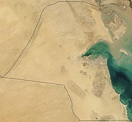
As previously mentioned, Kuwait borders the Persian Gulf with 195 km (121 mi) of coast.[1] Within its territory are ten islands, two of which, Bubiyan (the largest) and Warbah, are strategically important.[1]
Kuwait's most prominent geographic feature is Kuwait Bay (Jun al Kuwayt), which indents the shoreline for about forty kilometers, providing natural protection for the port of Kuwait, and accounts for nearly one third of the country's shoreline.[1]
To the south and west, Kuwait shares a 250-km border with Saudi Arabia.[1] The boundary between Kuwait and Saudi Arabia was set by the Treaty of Al Uqayr in 1922, which also established the Saudi–Kuwaiti neutral zone of 5,700 square kilometers between the two nations.[1] In 1966, Kuwait and Saudi Arabia agreed to divide the neutral zone; the partitioning agreement making each country responsible for administration in its portion was signed in December 1969.[1] The resources in the area, now known as the Divided Zone, are not affected by the agreement.[1] The oil from onshore and offshore fields continues to be shared equally between the two countries.[1]
The third side of the triangle-shaped nation is the 240 kilometers of historically contested border between Kuwait and Iraq.[1] Although the Iraqi government, which had first asserted a claim to rule Kuwait in 1938, recognized the borders with Kuwait in 1963 (based on agreements made earlier in the century), it continued to press Kuwait for control over Bubiyan and Warbah islands through the 1960s and 1970s.[1]
In August 1990, Iraq invaded Kuwait and, shortly thereafter, formally incorporated the entire country into Iraq.[1] Under United Nations (UN) Security Council Resolution 687, after the restoration of Kuwaiti sovereignty in 1991, a UN commission undertook formal demarcation of the borders on the basis of those agreed to in 1963.[1] The boundary was demarcated in 1992.[1] Iraq initially refused to accept the commission's findings[1] but ultimately accepted them in November 1994.[2][3]
Climate[]
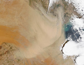
Kuwait has a hot and dry arid climate.[1] Rainfall in the nation varies from 75 to 150 millimeters (2.95 to 5.91 in) a year.[1] Actual rainfall has ranged from 25 millimeters (0.98 in) a year to as much as 325 millimeters (12.8 in).[1] In summer, average daily high temperatures range from 42 to 46 °C (108 to 115 °F);[1] the highest ever temperature recorded in Kuwait was 54 °C (129 °F) at Mitribah on 21 July 2016 which is the highest recorded temperature in Asia and also the third highest in the world.[4][5] The summers are relentlessly long, punctuated mainly by dramatic dust storms in June and July when northwesterly winds cover the cities in sand.[1] In late summer, which is more humid, there are occasional sharp, brief thunderstorms.[1]
By November summer is over, and colder winter weather sets in, dropping temperatures to as low as 3 °C (37 °F) at night; daytime temperatures are in the upper 20s °C (upper 70s to low 80s °F).[1] Frost rarely occurs; rain is more common and falls mostly in the spring.[1]
Kuwait's winter is colder than in other Persian Gulf countries, such as Bahrain, Qatar or United Arab Emirates. Kuwait experiences colder weather because it is situated farther north, and because of cold winds blowing from upper Iraq and Iran.[citation needed]
Geology and aquifers[]
The land was formed in a recent geologic era. In the south, limestone rises in a long, north-oriented dome that lies beneath the surface.[1] It is within and below this formation that the principal oil fields, Kuwait's most important natural resource, are located.[1] In the west and north, layers of sand, gravel, silt, and clay overlie the limestone to a depth of more than 210 meters.[1] The upper portions of these beds are part of a mass of sediment deposited by a great wadi whose most recent channel was the Wadi al Batin, the broad shallow valley forming the western boundary of the country.[1]
On the western side of the Al Rawdatayn geological formation, a freshwater aquifer was discovered in 1960 and became Kuwait's principal water source.[1] The supply is insufficient to support extensive irrigation, but it is tapped to supplement the distilled water supply that fills most of the country's needs.[1] The only other exploited aquifer lies in the permeable zone in the top of the limestone of the field south and east of the city of Kuwait.[1] Unlike water from the Al Rawdatayn aquifer, water from the Ash Shuaybah aquifer is brackish. Millions of liters a day of this water are pumped for commercial and household purposes.[1]
Human geography[]
The bulk of the Kuwaiti population lives in the coastal capital of the city of Kuwait. Smaller populations inhabit the nearby city of Al Jahrah, smaller desert and coastal towns, and, prior to the Persian Gulf War, some of the several nearby gulf islands, notably Faylakah.[1]
Area boundaries[]
- Area
-
- Total: 17,818 km²
- Land: 17,818 km²
- Water: 0 km²
- Area—comparative
- Slightly smaller than Fiji
- Land boundaries
-
- Total: 475 km
- Border countries: Iraq 254 km, Saudi Arabia 221 km
- Coastline
- 499 km
- Maritime claims
- Exclusive Economic Zone
- 11,026 km2 (4,257 sq mi)
- Territorial sea: 12 nmi (22.2 km; 13.8 mi)
- Elevation extremes
-
- Lowest point: Persian Gulf 0 m
- Highest point: Mutla Ridge 306 m
Resources and land use[]
- Natural resources
- Petroleum, fish, shrimp, natural gas
- Land use
-
- Arable land: 0.6%
- Permanent crops: 0.3%
- Permanent pasture: 7.6%
- Forest: 0.4%
- Other: 91.1% (2011)
- Irrigated land
- 86 km² (2007)
- Total renewable water resources
- 0.02 km3 (2011)
- Freshwater withdrawal (domestic/industrial/agricultural)
-
- Total: 0.91 km3/yr (47%/2%/51%)
- Per capita: 441.2 m3/yr (2005)
Environmental concerns[]

- Natural hazards
- Sudden cloudbursts are common from October to April – they bring heavy rain which can damage roads and houses; sandstorms and dust storms occur throughout the year, but are most common between March and August
- Environment—current issues
- Limited natural fresh water resources; some of world's largest and most sophisticated desalination facilities provide much of the water; air and water pollution; desertification
- Environment—international agreements
-
- Party to: Biodiversity, Climate Change, Climate Change-Kyoto Protocol, Desertification, Endangered Species, Environmental Modification, Hazardous Wastes, Law of the Sea
References[]
- ^ a b c d e f g h i j k l m n o p q r s t u v w x y z aa ab ac ad ae Crystal, Jill (1994). "Kuwait: Geography". In Metz, Helen Chapin (ed.). Persian Gulf states: country studies (3rd ed.). Washington, D.C.: Federal Research Division, Library of Congress. pp. 47–50. ISBN 0-8444-0793-3. OCLC 29548413.
 This article incorporates text from this source, which is in the public domain.
{{cite encyclopedia}}: CS1 maint: postscript (link) - ^ "Iraq". The World Factbook. Central Intelligence Agency. 2000. Archived from the original on 11 December 2000. Retrieved 1 September 2021.
- ^ Crossette, Barbara (11 November 1994). "Iraqis to accept Kuwait's borders". The New York Times. p. A1.
- ^ "WMO verifies 3rd and 4th hottest temperature recorded on Earth". public.wmo.int/en. World Meteorological Organization (WMO). 18 June 2019. Archived from the original on 18 June 2019. Retrieved 5 July 2019.
- ^ "Upgraded HWRF and GFDL Hurricane Models Excelled During Hurricane Arthur". Weather Underground. USA: Dr. Jeff Masters. 11 July 2014. Archived from the original on 17 January 2013. Retrieved 13 July 2014.
- This article incorporates public domain material from the CIA World Factbook website https://www.cia.gov/the-world-factbook/.
| History |
|  | |
|---|---|---|---|
| Geography | |||
| Politics |
| ||
| Economy | |||
| Culture | |||
| Sovereign states |
|
|---|---|
| States with limited recognition | |
| Dependencies and other territories |
|
| |
| Sovereign states |
|
|---|---|
| States with limited recognition |
|
| Dependencies and other territories |
|
| |
- Geography of Kuwait