Glen St. Mary, Florida
Parts of this article (those related to demographics) need to be updated. (July 2018) |
Glen St. Mary, Florida
Home of the Wildcats | |
|---|---|
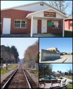 Top, left to right: Glen St. Mary Town Hall, CSX Tallahassee Subdivision railroad, Baker County High School, Celebration Park | |
 Location in Baker County and the state of Florida | |
| Coordinates: 30°16′34″N 82°9′41″W / 30.27611°N 82.16139°WCoordinates: 30°16′34″N 82°9′41″W / 30.27611°N 82.16139°W | |
| Country | |
| State | |
| County | Baker |
| Area | |
| • Total | 0.46 sq mi (1.19 km2) |
| • Land | 0.46 sq mi (1.19 km2) |
| • Water | 0.00 sq mi (0.00 km2) |
| Elevation | 131 ft (40 m) |
| Population (2010) | |
| • Total | 437 |
| • Estimate (2019)[4] | 460 |
| • Density | 1,004.37/sq mi (387.94/km2) |
| Time zone | UTC-5 (Eastern (EST)) |
| • Summer (DST) | UTC-4 (EDT) |
| FIPS code | 12-26075[2] |
| GNIS feature ID | 0283111[3] |
| Website | glenstmary |

Glen St. Mary is a town in Baker County, Florida, United States. In 2010, the population recorded by the U.S. Census Bureau was 437.[5]
Geography[]
Glen St. Mary is located at 30°16′34″N 82°9′41″W / 30.27611°N 82.16139°W (30.275987, -82.161408).[6]
According to the United States Census Bureau, the town has a total area of 0.4 square miles (1.0 km2), all land.
Climate[]
| hideClimate data for Glen St. Mary 1W, Florida, 1991-2020 normals | |||||||||||||
|---|---|---|---|---|---|---|---|---|---|---|---|---|---|
| Month | Jan | Feb | Mar | Apr | May | Jun | Jul | Aug | Sep | Oct | Nov | Dec | Year |
| Average high °F (°C) | 67.1 (19.5) |
70.6 (21.4) |
75.9 (24.4) |
81.7 (27.6) |
87.6 (30.9) |
91.1 (32.8) |
92.8 (33.8) |
91.8 (33.2) |
88.8 (31.6) |
82.5 (28.1) |
75.0 (23.9) |
69.4 (20.8) |
81.2 (27.3) |
| Daily mean °F (°C) | 53.5 (11.9) |
57.1 (13.9) |
61.8 (16.6) |
67.5 (19.7) |
74.2 (23.4) |
79.8 (26.6) |
82.0 (27.8) |
81.6 (27.6) |
78.6 (25.9) |
70.6 (21.4) |
62.1 (16.7) |
56.2 (13.4) |
68.7 (20.4) |
| Average low °F (°C) | 40.0 (4.4) |
43.7 (6.5) |
47.7 (8.7) |
53.3 (11.8) |
60.7 (15.9) |
68.5 (20.3) |
71.2 (21.8) |
71.4 (21.9) |
68.3 (20.2) |
58.7 (14.8) |
49.2 (9.6) |
42.9 (6.1) |
56.3 (13.5) |
| Average precipitation inches (mm) | 3.68 (93) |
3.51 (89) |
3.71 (94) |
3.10 (79) |
2.87 (73) |
8.42 (214) |
6.76 (172) |
7.12 (181) |
5.84 (148) |
3.65 (93) |
1.93 (49) |
2.63 (67) |
53.22 (1,352) |
| Average precipitation days (≥ 0.01 in) | 8.2 | 7.6 | 7.7 | 5.9 | 6.3 | 13.5 | 13.9 | 14.5 | 10.2 | 6.8 | 5.5 | 6.2 | 106.3 |
| Source: NOAA[7][8] | |||||||||||||
Demographics[]
| Historical population | |||
|---|---|---|---|
| Census | Pop. | %± | |
| 1960 | 329 | — | |
| 1970 | 357 | 8.5% | |
| 1980 | 462 | 29.4% | |
| 1990 | 480 | 3.9% | |
| 2000 | 473 | −1.5% | |
| 2010 | 437 | −7.6% | |
| 2019 (est.) | 460 | [4] | 5.3% |
| U.S. Decennial Census[5] | |||
At the 2000 census,[2] there were 473 people, 181 households and 131 families residing in the town. The population density was 1,127.1 per square mile (434.8/km2). There were 196 housing units at an average density of 467.0 per square mile (180.2/km2). The racial makeup of the town was 97.89% White, 0.63% African American, 0.42% Native American, 0.63% Asian, and 0.42% from two or more races. Hispanic or Latino of any race were 1.90% of the population.
There were 181 households, of which 45.9% had children under the age of 18 living with them, 54.1% were married couples living together, 16.51% had a female householder with no husband present, and 27.1% were non-families. 24.9% of all households were made up of individuals, and 11.6% had someone living alone who was 65 years of age or older. The average household size was 2.61 and the average family size was 3.2.
30.4% of the population were under the age of 18, 9.9% from 18 to 24, 25.8% from 25 to 44, 23.5% from 45 to 64, and 10.4% who were 65 years of age or older. The median age was 32 years. For every 100 females, there were 90.0 males. For every 100 females age 18 and over, there were 85.9 males.
The median household income was $28,906 and the median family income was $29,833. Males had a median income of $23,182 and females $20,625. The per capita income was $12,954. About 14.5% of families and 12.7% of the population were below the poverty line, including 28.7% of those under age 18 and 12.8% of those age 65 or over.
References[]
- ^ "2019 U.S. Gazetteer Files". United States Census Bureau. Retrieved July 2, 2020.
- ^ Jump up to: a b "U.S. Census website". United States Census Bureau. Retrieved January 31, 2008.
- ^ "US Board on Geographic Names". United States Geological Survey. October 25, 2007. Retrieved January 31, 2008.
- ^ Jump up to: a b "Population and Housing Unit Estimates". United States Census Bureau. May 24, 2020. Retrieved May 27, 2020.
- ^ Jump up to: a b "Census of Population and Housing". Census.gov. Retrieved June 4, 2015.
- ^ "US Gazetteer files: 2010, 2000, and 1990". United States Census Bureau. February 12, 2011. Retrieved April 23, 2011.
- ^ "NOWData - NOAA Online Weather Data". National Oceanic and Atmospheric Administration. Retrieved June 24, 2021.
- ^ "Summary of Monthly Normals 1991-2020". National Oceanic and Atmospheric Administration. Retrieved June 24, 2021.
External links[]
- Glen St. Mary, Florida. Official website. Accessed March 13, 2007.
| Wikimedia Commons has media related to Glen St. Mary, Florida. |
| show Municipalities and communities of Baker County, Florida, United States |
|---|


| show Authority control |
|---|
- Towns in Baker County, Florida
- Towns in the Jacksonville metropolitan area
- Towns in Florida