Gogango
| Gogango Queensland | |||||||||||||||
|---|---|---|---|---|---|---|---|---|---|---|---|---|---|---|---|
 Fitzroy River near Gogango | |||||||||||||||
 Gogango | |||||||||||||||
| Coordinates | 23°40′00″S 150°02′32″E / 23.6666°S 150.0422°E | ||||||||||||||
| Population | 111 (2016 census locality)[1] | ||||||||||||||
| • Density | 0.1402/km2 (0.3630/sq mi) | ||||||||||||||
| Postcode(s) | 4702 | ||||||||||||||
| Area | 791.9 km2 (305.8 sq mi) | ||||||||||||||
| Time zone | AEST (UTC+10:00) | ||||||||||||||
| LGA(s) | Rockhampton Region | ||||||||||||||
| State electorate(s) | Mirani | ||||||||||||||
| Federal Division(s) | Flynn | ||||||||||||||
| |||||||||||||||

Gogango is a rural town and locality in the Rockhampton Region, Queensland, Australia.[2][3] In the 2016 census the locality of Gogango had a population of 111 people.[1]
Geography[]
Gogango is in Central Queensland. The Capricorn Highway traverses the south of the locality passing through the town which is situated in the south-east corner of the locality. The Central Western railway line also traverses the south of the locality mostly parallel and to the immediate north of the highway.[4] The town is serviced by Gogango railway station (23°39′55″S 150°02′25″E / 23.6653°S 150.0404°E), while Grantleigh railway station (23°42′05″S 149°59′42″E / 23.7013°S 149.9951°E) serves the south-west of the locality.[5][6][7]
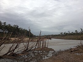
The Fitzroy River flows from west to east through the centre of the locality. Gogango Creek flows from south to north through the town and is a tributary of the Fitzroy River.[4]
The principal land use is farming, mostly grazing cattle.[8]
History[]
Goganjo Provisional School opened in 1874 but closed circa 1878. In 1888 it renamed under the name Gogango Provisional School (note change of spelling) becoming Gogango State School on 1 January 1909.[9]
On 29 November 1950, the Gogango Hall held an Ambulance Ball. People from Westwood, Mt Morgan and Rockhampton attended.
In the 2010-11 Queensland floods the Fitzroy River which passes through the area of Gogango rose to 28 metres. Gogango Creek also flooded, stopping traffic on the Capricorn Highway.[citation needed]
At the 2011 census, Gogango and the surrounding area had a population of 310.[10]
The Capricorn Highway was also flooded for more than 12 hours in January 2013.[citation needed]
In February 2015, Cyclone Marcia caused heavy rainfall which led to Gogango Creek rising over the highway.[citation needed]
In the 2016 census the locality of Gogango had a population of 111 people.[1]
Infrastructure[]
Rookwood Weir, currently under construction, is located on the Fitzroy River in the Gogango area, about 15 km from the township. When completed the $72 million weir will hold over 100 thousand megalitres. The Weir will be built over 2 stages, The first stage will be 17 metres high and the second stage will be 0.5 metre, With a complete height of 17.5 meters, inundating 1,930 hectares.[11]
Economy[]
There are a number of homesteads in the locality, including:[12]
- Rookwood (23°27′42″S 149°50′12″E / 23.4618°S 149.8366°E)
- Separation (23°35′14″S 149°47′00″E / 23.5873°S 149.7834°E)
- Weir Park (23°32′19″S 149°58′47″E / 23.5386°S 149.9798°E)
- Yarra (23°33′31″S 149°53′05″E / 23.5585°S 149.8846°E)
Transport[]
There are a number of airstrips in the locality, all of them associated with the homesteads:
- Rookwood airstrip (23°28′02″S 149°49′57″E / 23.4671°S 149.8324°E)[13]
- Separation airstrip (23°35′36″S 149°46′53″E / 23.5934°S 149.7813°E)[13]
- Weir Park airstrip (23°32′26″S 149°58′51″E / 23.5406°S 149.9808°E)[13]
- Yarra airstrip (23°33′41″S 149°53′02″E / 23.5614°S 149.8839°E)[13]
Education[]
Gogango State School is a government primary (Prep-6) school for boys and girls at 10 Wills Street (23°39′53″S 150°02′40″E / 23.6647°S 150.0444°E).[14][15] In 2016, the school had an enrolment of 9 students with 3 teachers (1 full-time equivalent) and 4 non-teaching staff (2 full-time equivalent).[8] In 2018, the school had an enrolment of 7 students with 4 teachers (2 full-time equivalent) and 4 non-teaching staff (1 full-time equivalent).[16]
There is no secondary school in Gogango. The nearest secondary school is Rockhampton State High School in Wandal in Rockhampton to the north-east. A school bus service is available.[8]
Facilities[]
Dunphy Park is at the corner of Third Street and Wills Street (23°39′59″S 150°02′28″E / 23.6665°S 150.0412°E). It has picnic tables and shade areas.[17]
There is a community hall where the Gogango Honour Roll is displayed.[18]
There is a volunteer rural fire brigade.[19]
Notable people[]
- Barry O'Sullivan, Australian Senator, was born in Gogango
References[]
- ^ Jump up to: a b c Australian Bureau of Statistics (27 June 2017). "Gogango (SSC)". 2016 Census QuickStats. Retrieved 20 October 2018.

- ^ "Gogango – town in Rockhampton Region (entry 14122)". Queensland Place Names. Queensland Government. Retrieved 28 December 2020.
- ^ "Gogango – locality in Rockhampton Region (entry 48657)". Queensland Place Names. Queensland Government. Retrieved 28 December 2020.
- ^ Jump up to: a b "Queensland Globe". State of Queensland. Retrieved 11 February 2021.
- ^ "Railway stations and sidings - Queensland". Queensland Open Data. Queensland Government. 2 October 2020. Archived from the original on 5 October 2020. Retrieved 5 October 2020.
- ^ "Gogango – railway station in the Rockhampton Region (entry 14123)". Queensland Place Names. Queensland Government. Retrieved 15 November 2017.
- ^ "Grantleigh – railway station in the Rockhampton Region (entry 14612)". Queensland Place Names. Queensland Government. Retrieved 11 February 2021.
- ^ Jump up to: a b c "2016 Annual Report" (PDF). Gogango State School. Archived (PDF) from the original on 15 November 2017. Retrieved 15 November 2017.
- ^ Queensland Family History Society (2010), Queensland schools past and present (Version 1.01 ed.), Queensland Family History Society, ISBN 978-1-921171-26-0
- ^ Australian Bureau of Statistics (31 October 2012). "Gogango (State Suburb)". 2011 Census QuickStats. Retrieved 19 November 2014.
- ^ "Statewide Water Policy: Quarterly Project Progress Report: February 2009" (PDF). Queensland Government. Archived (PDF) from the original on 16 November 2017. Retrieved 16 November 2017.
- ^ "Homesteads - Queensland". Queensland Open Data. Queensland Government. 18 November 2020. Archived from the original on 24 November 2020. Retrieved 24 November 2020.
- ^ Jump up to: a b c d "Heliports and landing grounds - Queensland". Queensland Open Data. Queensland Government. 22 October 2020. Archived from the original on 16 November 2020. Retrieved 3 November 2020.
- ^ "State and non-state school details". Queensland Government. 9 July 2018. Archived from the original on 21 November 2018. Retrieved 21 November 2018.
- ^ "Gogango State School". Retrieved 11 February 2021.
- ^ "ACARA School Profile 2018". Australian Curriculum, Assessment and Reporting Authority. Archived from the original on 27 August 2020. Retrieved 28 January 2020.
- ^ "Dunphy Park". Rockhampton Regional Council. Retrieved 11 February 2021.
- ^ "Gogango Honour Board | Monument Australia". Monument Australia. Retrieved 11 February 2021.
- ^ "Forty years of service: the legend of Wombat". Queensland Fire and Emergency Services Newsroom. Retrieved 11 February 2021.
External links[]
- Towns in Queensland
- Suburbs of Rockhampton Region
- Localities in Queensland