Jambin, Queensland
| Jambin Queensland | |||||||||||||||
|---|---|---|---|---|---|---|---|---|---|---|---|---|---|---|---|
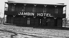 Jambin Hotel, circa 1920 | |||||||||||||||
 Jambin | |||||||||||||||
| Coordinates | 24°10′23″S 150°22′29″E / 24.1730°S 150.3747°E | ||||||||||||||
| Postcode(s) | 4702 | ||||||||||||||
| Area | 279.5 km2 (107.9 sq mi) | ||||||||||||||
| Time zone | AEST (UTC+10:00) | ||||||||||||||
| Location |
| ||||||||||||||
| LGA(s) | Shire of Banana | ||||||||||||||
| State electorate(s) | Callide | ||||||||||||||
| Federal division(s) | Flynn | ||||||||||||||
| |||||||||||||||
Jambin is a rural town and locality in the Shire of Banana, Queensland, Australia.[1][2]
Geography[]
Jambin is located in Central Queensland on the Burnett Highway which runs roughly north-south through the town. Callide Creek is immediately to the west of the town; it is a tributary of the Don River.[3]
The Callide Valley railway line passed through the locality with Jambin railway station (24°11′44″S 150°22′11″E / 24.1955°S 150.3697°E) serving the town. That section of the line is now closed and the station abandoned.[4]
However, other parts of the Callide Valley line in Jamin were integrated into the Moura railway line, which serves the mining industry, connecting mines with the Port of Gladstone.[5] The following stations in Jambin are on the Moura line:
- Argoon railway station (24°15′15″S 150°26′01″E / 24.2541°S 150.4336°E)[4]
- Koonkool railway station (24°14′17″S 150°25′19″E / 24.2380°S 150.4220°E)[4]
- Earlsfield railway station (24°13′43″S 150°24′58″E / 24.2287°S 150.4161°E)[4]
- Annandale railway station (24°11′30″S 150°27′51″E / 24.1917°S 150.4642°E)[4]
- Boundary Hill railway station (24°12′22″S 150°28′42″E / 24.2062°S 150.4782°E)[4]
All of these stations are operational apart from Argoon which is now abandoned.[4] Boundary Hill station is on a balloon loop that serves the Boundary Hill coal mine (in neighbouring Callide).[3]
History[]
The town takes its name from the Jambin railway station, which in turn was named on 27 April 1923 by the Queensland Railway Department and is believed to be an Aboriginal word meaning echidna.[1]
The town first appears on an 1949 survey map.[1]
Jambin was originally established as a supply depot for the railway, which was established in 1924.[6] This opened up the area for new settlers, many of them pursuing dairying.[7] Cream was sent to the butter factory at Wowan.[8]
Jambin Post Office opened on 1 February 1926 (a receiving office had been open from 1924).[9]
Jambin State School opened on 11 February 1929.[10][11]
The mobile library service commenced in 2004.[12]
The locality of Jambin was created 25 November 2016. The northern part of the new locality was formerly the locality of Smoky Creek and the southern part of the new locality was formerly the locality of Argoon.[1] In the 2011 census Smoky Creek had a population of 308 people[13] and Argoon had a population of 295.[14] In the 2016 census, Smoky Creek had a population of 179 people[15] and Argoon had a population of 151.[16]
Heritage listings[]
Jambin has a number of heritage-listed sites, including:
- Argoon-Kilburnie Road: Kilbirnie Homestead[17]
Events[]
Jambin hosts its annual Champagne Campdraft in May each year.[18]
The annual Working Cattle Dog trials are held in June.[18]
Since 2017, the annual King and Queen of CQ Boar Hunting Competition has been held over three days in either late May or early June.[19] In what is claimed to be Australia's largest boar hunting competition, hundreds of competitors compete for prizes in an attempt to cull the boar population while raising money for schools in Jambin and Goovigen.[20] Almost 900 pigs were killed in the 2021 competition which attracted hunters from New South Wales and North Queensland.[21]
Amenities[]
Banana Shire Council operate a fortnightly mobile library service to Jambin and the school.[22][23]
The Jambin branch of the Queensland Country Women's Association meets in the QCWA Room in the Jambin Hall at 180 Burnett Highway.[24]
In popular culture[]
The novel "Dust" by Christine Bongers is set around the town of Jambin. In the novel the main character's family, the Vanderbomms, attend church at Jambin.[25]
References[]
- ^ a b c d "Jambin – town in Shire of Banana (entry 17026)". Queensland Place Names. Queensland Government. Retrieved 26 December 2020.
- ^ "Jambin – locality in Shire of Banana (entry 49780)". Queensland Place Names. Queensland Government. Retrieved 26 December 2020.
- ^ a b "Queensland Globe". State of Queensland. Retrieved 3 January 2021.
- ^ a b c d e f g "Railway stations and sidings - Queensland". Queensland Open Data. Queensland Government. 2 October 2020. Archived from the original on 5 October 2020. Retrieved 5 October 2020.
- ^ "What We Deliver". Aurizon. Retrieved 3 January 2021.
- ^ "Jambin". The Gladstone Region. Tourism Queensland. Archived from the original on 27 June 2014. Retrieved 7 June 2014.
- ^ "CALLIDE-NEW SETTLERS". Morning Bulletin (Rockhampton, Qld. : 1878 - 1954). Rockhampton, Qld.: National Library of Australia. 20 February 1924. p. 3. Retrieved 8 June 2014.
- ^ "DAWSON VALLEY NEWS". Morning Bulletin (Rockhampton, Qld. : 1878 - 1954). Rockhampton, Qld.: National Library of Australia. 1 March 1924. p. 10. Retrieved 8 June 2014.
- ^ Premier Postal History. "Post Office List". Premier Postal Auctions. Retrieved 10 May 2014.
- ^ "Jambin SS". Archived from the original on 2 February 2017. Retrieved 29 January 2017.
- ^ "Opening and closing dates of Queensland Schools". Queensland Government. Retrieved 4 June 2014.
- ^ "Public Libraries Statistical Bulletin 2016-17" (PDF). Public Libraries Connect. State Library of Queensland. November 2017. p. 11. Archived (PDF) from the original on 30 January 2018. Retrieved 29 January 2018.
- ^ Australian Bureau of Statistics (31 October 2012). "Smoky Creek (SSC)". 2011 Census QuickStats. Retrieved 4 June 2014.
- ^ Australian Bureau of Statistics (31 October 2012). "Argoon (SSC)". 2011 Census QuickStats. Retrieved 4 June 2014.
- ^ Australian Bureau of Statistics (27 June 2017). "Smoky Creek (SSC)". 2016 Census QuickStats. Retrieved 24 May 2019.
- ^ Australian Bureau of Statistics (27 June 2017). "Argoon (SSC)". 2016 Census QuickStats. Retrieved 24 May 2017.
- ^ "Kilbirnie Homestead (entry 600016)". Queensland Heritage Register. Queensland Heritage Council. Retrieved 6 July 2013.
- ^ a b "Simple Pleasures: Banana Shire" (PDF). The Gladstone Region. Tourism Queensland. p. 3. Archived (PDF) from the original on 15 July 2014. Retrieved 8 June 2014.
- ^ "Family fun day of hunting pigs for $10k in prizes". Central Telegraph. 9 May 2017. Retrieved 11 June 2021.
- ^ Robinson, Paul (4 June 2018). "Hundreds of feral pigs caught and killed in Australia's largest hunting competition". ABC News. Retrieved 11 June 2021.
- ^ Jurss-Lewis, Tobias (11 June 2021). "Hunting feral boars in central Queensland in guerrilla war on damaging pest". ABC News. Retrieved 11 June 2021.
- ^ "Library: Branches & Opening hours". Banana Shire Council. Archived from the original on 19 March 2017. Retrieved 8 May 2017.
- ^ "Banana Shire Mobile Library Timetable" (PDF). Banana Shire Council. Retrieved 8 May 2017.[permanent dead link]
- ^ "Branch Locations". Queensland Country Women's Association. Archived from the original on 26 December 2018. Retrieved 26 December 2018.
- ^ "Dust settles as Jambin book launched". Central Telegraph. 13 August 2009. Archived from the original on 14 July 2014. Retrieved 7 June 2014.
Further reading[]
- Lightfoot, Jim; Australia Post (1979), Jambin, Australia Post
- Maynard, Ruth; Jambin State School (1979), Jambin State School 1929-1979 Golden Jubilee, Jambin State School
- Jambin State School : reflections of 75 years 1929-2004, Jambin State School, 2004
- Bongers, Christine (2009), Dust, Random House Australia, ISBN 978-1-74166-446-1
- Towns in Queensland
- Jambin, Queensland
- Shire of Banana
- Localities in Queensland