Good Thunder, Minnesota
Good Thunder | |
|---|---|
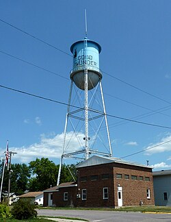 Water tower | |
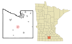 Location of Good Thunder, Minnesota | |
| Coordinates: 44°0′15″N 94°4′9″W / 44.00417°N 94.06917°W | |
| Country | United States |
| State | Minnesota |
| County | Blue Earth |
| Government | |
| • Type | Mayor - Council |
| • Mayor | Robert Anderson |
| Area | |
| • Total | 0.63 sq mi (1.62 km2) |
| • Land | 0.63 sq mi (1.62 km2) |
| • Water | 0.00 sq mi (0.00 km2) |
| Elevation | 991 ft (302 m) |
| Population | |
| • Total | 583 |
| • Estimate (2019)[2] | 565 |
| • Density | 901.12/sq mi (348.07/km2) |
| Time zone | UTC-6 (Central (CST)) |
| • Summer (DST) | UTC-5 (CDT) |
| ZIP code | 56037 |
| Area code(s) | 507 |
| FIPS code | 27-24506[4] |
| GNIS feature ID | 0644218[5] |

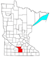
Good Thunder is a city in Blue Earth County, Minnesota, United States, situated along the Maple River. The population was 583 at the 2010 census.[6] It is part of the Mankato–North Mankato Metropolitan Statistical Area.
Geography[]

According to the United States Census Bureau, the city has a total area of 0.64 square miles (1.66 km2), all land.[7]
Former State Highway 66; and County Roads 1 and 10 are three of the main routes in the community.
Demographics[]
| Historical population | |||
|---|---|---|---|
| Census | Pop. | %± | |
| 1880 | 149 | — | |
| 1900 | 505 | — | |
| 1910 | 419 | −17.0% | |
| 1920 | 464 | 10.7% | |
| 1930 | 452 | −2.6% | |
| 1940 | 457 | 1.1% | |
| 1950 | 476 | 4.2% | |
| 1960 | 468 | −1.7% | |
| 1970 | 489 | 4.5% | |
| 1980 | 560 | 14.5% | |
| 1990 | 561 | 0.2% | |
| 2000 | 592 | 5.5% | |
| 2010 | 583 | −1.5% | |
| 2019 (est.) | 565 | [2] | −3.1% |
| U.S. Decennial Census[8] 2018 Estimate[9] | |||
2010 census[]
As of the census[3] of 2010, there were 583 people, 227 households, and 155 families living in the city. The population density was 910.9 inhabitants per square mile (351.7/km2). There were 242 housing units at an average density of 378.1 per square mile (146.0/km2). The racial makeup of the city was 98.1% White, 1.4% African American, 0.2% Native American, and 0.3% from two or more races. Hispanic or Latino of any race were 1.0% of the population.
There were 227 households, of which 36.1% had children under the age of 18 living with them, 53.7% were married couples living together, 8.8% had a female householder with no husband present, 5.7% had a male householder with no wife present, and 31.7% were non-families. 24.2% of all households were made up of individuals, and 7.9% had someone living alone who was 65 years of age or older. The average household size was 2.57 and the average family size was 3.09.
The median age in the city was 34 years. 27.4% of residents were under the age of 18; 7.8% were between the ages of 18 and 24; 29.7% were from 25 to 44; 24% were from 45 to 64; and 10.8% were 65 years of age or older. The gender makeup of the city was 49.4% male and 50.6% female.
2000 census[]
As of the census[4] of 2000, there were 592 people, 217 households, and 161 families living in the city. The population density was 945.7 people per square mile (362.8/km2). There were 233 housing units at an average density of 372.2 per square mile (142.8/km2). The racial makeup of the city was 97.64% White, 0.17% African American, 0.17% Native American, 0.34% Asian, and 1.69% from two or more races.
There were 217 households, out of which 43.8% had children under the age of 18 living with them, 63.6% were married couples living together, 8.3% had a female householder with no husband present, and 25.8% were non-families. 24.0% of all households were made up of individuals, and 12.0% had someone living alone who was 65 years of age or older. The average household size was 2.73 and the average family size was 3.21.

In the city, the population was spread out, with 32.8% under the age of 18, 8.8% from 18 to 24, 31.3% from 25 to 44, 16.4% from 45 to 64, and 10.8% who were 65 years of age or older. The median age was 31 years. For every 100 females, there were 94.1 males. For every 100 females age 18 and over, there were 90.4 males.
The median income for a household in the city was $42,500, and the median income for a family was $45,469. Males had a median income of $31,375 versus $21,146 for females. The per capita income for the city was $14,524. About 12.4% of families and 13.0% of the population were below the poverty line, including 16.7% of those under age 18 and 19.3% of those age 65 or over.
History[]

Good Thunder was platted in 1871, and named for a Winnebago chief.[10]
See also[]
References[]
- ^ "2019 U.S. Gazetteer Files". United States Census Bureau. Retrieved July 26, 2020.
- ^ Jump up to: a b "Population and Housing Unit Estimates". United States Census Bureau. May 24, 2020. Retrieved May 27, 2020.
- ^ Jump up to: a b "U.S. Census website". United States Census Bureau. Retrieved November 13, 2012.
- ^ Jump up to: a b "U.S. Census website". United States Census Bureau. Retrieved January 31, 2008.
- ^ "US Board on Geographic Names". United States Geological Survey. October 25, 2007. Retrieved January 31, 2008.
- ^ "2010 Census Redistricting Data (Public Law 94-171) Summary File". American FactFinder. United States Census Bureau. Retrieved April 27, 2011.[dead link]
- ^ "US Gazetteer files 2010". United States Census Bureau. Archived from the original on January 12, 2012. Retrieved November 13, 2012.
- ^ "Census of Population and Housing". Census.gov. Retrieved June 4, 2015.
- ^ "Population Estimates". United States Census Bureau. Retrieved July 5, 2019.
- ^ Upham, Warren (1920). Minnesota Geographic Names: Their Origin and Historic Significance. Minnesota Historical Society. p. 59.
| show Municipalities and communities of Blue Earth County, Minnesota, United States |
|---|

Coordinates: 44°00′17″N 94°03′57″W / 44.00472°N 94.06583°W
| show Authority control |
|---|
- Cities in Blue Earth County, Minnesota
- Cities in Minnesota
- Mankato – North Mankato metropolitan area
- 1871 establishments in Minnesota