Gorham, Maine
Gorham, Maine | |
|---|---|
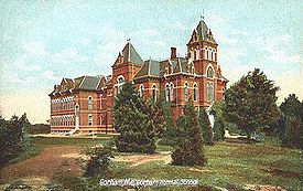
 Gorham Academy Building, c. 1906 | |
 Seal | |
| Motto(s): "Grow with Us" | |
 Location in Cumberland County and the state of Maine. | |
| Coordinates: 43°42′7″N 70°27′20″W / 43.70194°N 70.45556°W | |
| Country | United States |
| State | Maine |
| County | Cumberland |
| Settled | 1736 |
| Incorporated | October 30, 1764 |
| Villages | Gorham Dog Corner Gag Corner Little Falls North Gorham South Gorham West Gorham White Rock |
| Government | |
| Area | |
| • Total | 51.29 sq mi (132.84 km2) |
| • Land | 50.62 sq mi (131.11 km2) |
| • Water | 0.67 sq mi (1.74 km2) |
| Elevation | 207 ft (63 m) |
| Population (2019)[2] | |
| • Total | 17,978 |
| • Estimate () | 17,978 |
| • Density | 323.6/sq mi (124.9/km2) |
| Demonym(s) | Gorhamite |
| Time zone | UTC-5 (Eastern (EST)) |
| • Summer (DST) | UTC-4 (EDT) |
| ZIP code | 04038 |
| Area code(s) | 207 Exchange: 839 |
| FIPS code | 23-28240 |
| GNIS feature ID | 0582493 |
| Website | www |

Gorham is a town in Cumberland County, Maine, United States. The population was 17,958 in a 2019 US Census estimate.[3] In addition to its urban village center known as Gorham Village or simply "the Village," the town encompasses a number of smaller, unincorporated villages and hamlets with distinct historical identities, including South Gorham, West Gorham, Little Falls, White Rock, and North Gorham. Gorham is home to one of the three campuses of the University of Southern Maine. In 2013, Gorham was voted second best town in Maine after Hampden by a financial website.
Gorham is part of the Portland–South Portland–Biddeford, Maine metropolitan statistical area.
Initially named Narragansett Number 7, the village was renamed Gorhamtown Plantation in honor of the famous New England Ranger John Gorham I,[4] the great grandfather of John Gorham 4th.[5]
History[]
First called Narragansett Number 7 was one of seven townships granted by the Massachusetts General Court to soldiers (or their heirs) who had fought in the Narragansett War of 1675, also called King Philip's War. The land was first settled in 1736 by Captain John Phinney and his family, followed in 1738 by Hugh McLellan and Daniel Mosher. By 1743, the first sawmill was established by John Gorham at Little River. Without window-glass, the first dwellings were constructed of logs chinked with moss and clay.[6]
Narragansett Number 7 suffered its first Indian raid in 1745 during King George's War, when the meeting house and Gorham's sawmill were burned. It was attacked again in 1746, when five colonists were killed and three abducted. Incursions during the French and Indian Wars would finally end, however, with the 1763 Treaty of Paris. The town was incorporated as Gorham in 1764.[7] It would annex land from Standish in 1831 and 1839, and from Scarborough in 1864.
Good soil benefited agriculture, and numerous falls provided water power for industry. The town developed into a manufacturing center, with Portland a nearby market. Products included textiles, clothing, carpet, lumber, barrels, chairmans, carriages, wagons and sleighs. There was also a box factory, corn-canning factory, paper pulp mill, brickyard, tannery, and granite and marble works. The Cumberland and Oxford Canal opened in 1829 connecting Casco Bay with Sebago Lake, although it would be discontinued in 1871, having been rendered obsolete by John A. Poor's York and Cumberland Railroad (later the Boston and Maine Railroad), which entered Gorham in 1851. The railroad was dismantled in 1961, but the former grade serves as a multi-use recreational trail. On September 12, 1870, the first train of the Portland and Ogdensburg Railroad (later part of the Maine Central Railroad Mountain Division) traveled from Portland to Sebago Lake through White Rock.[8] White Rock station closed in 1921.[9]
In 1803, Gorham Academy was founded. Designed by Samuel Elder, the Federal style Gorham Academy Building was erected in 1806. The institution would evolve into Western Maine Normal School, and later Gorham State Teachers College. Today, it is the University of Southern Maine at Gorham.[10]
Gorham currently has a much smaller industrial infrastructure than it did in the earlier years. The majority of Gorham's industry is based along the border with Westbrook, and many of the mills that formerly existed along the Presumpscot River are now under water, flooded with the construction of the Dundee Dam. In recent decades Gorham has increased in popularity as a bedroom community of Portland. Its residents and town officials have been confronted with various issues related to managing suburban growth in a historically rural town.[10] Today, Gorham has grown from a small village to a flourishing town. Its popularity has attracted many new housing developments and businesses. Positioned near Sebago Lake, Gorham also offers a plethora of recreational activities such as trails for hiking and the river for kayaking, canoeing and swimming.
Gallery[]

Hugh McLellan House, completed in 1773

Old mill in 1906
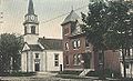
Congregational Church c. 1915


Geography[]
According to the United States Census Bureau, the town has a total area of 51.29 square miles (132.84 km2), of which, 50.62 square miles (131.11 km2) of it is land and 0.67 square miles (1.74 km2) is water.[1] Gorham is drained by the Little River, Presumpscot River and Stroudwater River.
Roads and bordering[]
The town is served by U.S. Route 202, and state routes 4, 22, 25, 112, 114 and 237. It borders Buxton, Standish, Windham, Westbrook, and Scarborough.
Demographics[]
| Historical population | |||
|---|---|---|---|
| Census | Pop. | %± | |
| 1800 | 2,503 | — | |
| 1810 | 2,632 | 5.2% | |
| 1820 | 2,795 | 6.2% | |
| 1830 | 2,988 | 6.9% | |
| 1840 | 3,001 | 0.4% | |
| 1850 | 3,088 | 2.9% | |
| 1860 | 3,252 | 5.3% | |
| 1870 | 3,351 | 3.0% | |
| 1880 | 3,233 | −3.5% | |
| 1890 | 2,888 | −10.7% | |
| 1900 | 2,540 | −12.0% | |
| 1910 | 2,822 | 11.1% | |
| 1920 | 2,870 | 1.7% | |
| 1930 | 3,035 | 5.7% | |
| 1940 | 3,494 | 15.1% | |
| 1950 | 4,742 | 35.7% | |
| 1960 | 5,767 | 21.6% | |
| 1970 | 7,839 | 35.9% | |
| 1980 | 10,101 | 28.9% | |
| 1990 | 11,856 | 17.4% | |
| 2000 | 14,141 | 19.3% | |
| 2010 | 16,381 | 15.8% | |
| 2014 (est.) | 17,024 | [11] | 3.9% |
| U.S. Decennial Census[12] | |||

2010 census[]
As of the census[2] of 2010, there were 16,381 people, 5,719 households, and 4,064 families living in the town. The population density was 323.6 inhabitants per square mile (124.9/km2). There were 5,972 housing units at an average density of 118.0 per square mile (45.6/km2). The racial makeup of the town was 96.5% White, 0.7% African American, 0.3% Native American, 0.9% Asian, 0.2% from other races, and 1.4% from two or more races. Hispanic or Latino of any race were 0.9% of the population.
There were 5,719 households, of which 36.0% had children under the age of 18 living with them, 57.1% were married couples living together, 9.9% had a female householder with no husband present, 4.0% had a male householder with no wife present, and 28.9% were non-families. 21.8% of all households were made up of individuals, and 9% had someone living alone who was 65 years of age or older. The average household size was 2.59 and the average family size was 3.03.
The median age in the town was 38 years. 22.6% of residents were under the age of 18; 15% were between the ages of 18 and 24; 22.8% were from 25 to 44; 27.8% were from 45 to 64; and 11.9% were 65 years of age or older. The gender makeup of the town was 48.3% male and 51.7% female.
2000 census[]
As of the census[13] of 2000, there were 14,141 people, 4,875 households, and 3,529 families living in the town. The population density was 279.2 people per square mile (107.8/km2). There were 5,051 housing units at an average density of 99.7 per square mile (38.5/km2). The racial makeup of the town was 97.57% White, 0.42% Black or African American, 0.33% Native American, 0.64% Asian, 0.01% Pacific Islander, 0.17% from other races, and 0.87% from two or more races. Hispanic or Latino of any race were 0.60% of the population.
There were 4,875 households, out of which 38.7% had children under the age of 18 living with them, 59.2% were married couples living together, 10.0% had a female householder with no husband present, and 27.6% were non-families. 20.5% of all households were made up of individuals, and 8.3% had someone living alone who was 65 years of age or older. The average household size was 2.67 and the average family size was 3.11.

In the town, the population was spread out, with 25.9% under the age of 18, 13.7% from 18 to 24, 28.9% from 25 to 44, 21.5% from 45 to 64, and 10.0% who were 65 years of age or older. The median age was 34 years. For every 100 females, there were 93.8 males. For every 100 females age 18 and over, there were 90.2 males.
The median income for a household in the town was $50,316, and the median income for a family was $55,434. Males had a median income of $37,828 versus $30,394 for females. The per capita income for the town was $21,174. About 5.1% of families and 7.4% of the population were below the poverty line, including 9.7% of those under age 18 and 6.7% of those age 65 or over.
Sites of interest[]
- Baxter House Museum
- Gorham Academy Building
- Gorham Historical Society
- University of Southern Maine Art Galleries
Education[]
Schools in Gorham are part of the Gorham School District. Heather Perry is the Superintendent.
The school district has three elementary schools (Village, Great Falls, and Narragansett), a middle school and a high school. For the 2011 to 2012 school year, the district had approximately 2,698 students enrolled.[14]
Notable people[]
- Wendell Abraham Anderson, politician
- James Phinney Baxter, historian, civic leader
- Percival Baxter, 53rd Governor of Maine
- Julie Berry, TV producer, Survivor: Vanuatu contestant
- James Boyle, state legislator
- Joseph Brackett, elder in Shakers sect and songwriter, most notably of Simple Gifts
- Bob Crowley, winner of Survivor: Gabon, physics teacher at Gorham High School
- Edwin Hall, physicist
- Isaiah H. Hedge, MD, abolitionist, early donor to Bates College, physician
- Charles Davis Jameson, lumberman, general
- Stephen Longfellow, US congressman
- James Mann, US congressman
- Josiah Pierce, Maine state senator and lawyer
- Rodney S. Quinn, Secretary of State of Maine (1979–1988)
- Frederick Robie, 39th governor of Maine
- Linda Sanborn, state legislator
- Donald F. Snow, US congressman
- Ellen G. White, religious leader
- Horace Wilson, professor and baseball promoter
- Shawn Moody, 2018 candidate for Governor of Maine, born in Gorham
- Peter Mills, former member of the Maine state Senate, raised in Gorham
- David Chittick (Ed Tech, Religious Leader) Amazing man that brought the community together in every way
See also[]
References[]
- ^ Jump up to: a b "US Gazetteer files 2010". United States Census Bureau. Retrieved December 16, 2012.
- ^ Jump up to: a b "U.S. Census website". United States Census Bureau. Retrieved December 16, 2012.
- ^ "US Census Estimate". US Census Bureau. Retrieved May 15, 2021.
- ^ Josiah Pierce. A History of the town of Gorham, Maine. p. 169
- ^ Hugh Davis McLellan, History of Gorham, Maine; Smith & Sale, printers; Portland, Maine 1903
- ^ Coolidge, Austin J.; John B. Mansfield (1859). A History and Description of New England. Boston, Massachusetts: A.J. Coolidge. pp. 141–142.
coolidge mansfield history description new england 1859.
- ^ Chadbourne, Ava H. (April 20, 1949). "Many Maine towns bear names of military men". Lewiston Evening Journal. pp. A-2. Retrieved October 17, 2015.
- ^ Varney, George J. (1886), Gazetteer of the state of Maine. Gorham, Boston: Russell
- ^ Johnson, Ron (n.d.). Maine Central R.R. Mountain Division. 470 Railroad Club.
- ^ Jump up to: a b Wright, Virginia. "Gorham at a Crossroads". Down East: The Magazine of Maine (June 2010).
- ^ "Annual Estimates of the Resident Population for Incorporated Places: April 1, 2010 to July 1, 2014". Archived from the original on May 23, 2015. Retrieved June 4, 2015.
- ^ "Census of Population and Housing". Census.gov. Retrieved June 4, 2015.
- ^ "U.S. Census website". United States Census Bureau. Retrieved January 31, 2008.
- ^ "Gorham School District". Gorham School District. Retrieved June 6, 2012.
External links[]
| Wikivoyage has a travel guide for Gorham, Maine. |
- Town of Gorham official website
- Baxter Memorial Library
- Gorham Historical Society
- University of Southern Maine
- Maine Genealogy: Gorham, Cumberland County, Maine
Coordinates: 43°40′46″N 70°26′39″W / 43.67944°N 70.44417°W
| show Municipalities and communities of Cumberland County, Maine, United States |
|---|

| show Authority control |
|---|
- Gorham, Maine
- Populated places established in 1736
- Populated places established in 1764
- Towns in Cumberland County, Maine
- Portland metropolitan area, Maine
- Towns in Maine
- 1736 establishments in the Thirteen Colonies