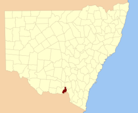
Parish
LGA
Coordinates
Albury City of Albury 36°02′54″S 146°54′04″E / 36.04833°S 146.90111°E / -36.04833; 146.90111 (Albury )
Greater Hume Shire Council 35°37′54″S 147°21′04″E / 35.63167°S 147.35111°E / -35.63167; 147.35111 (Back Creek )
Greater Hume Shire Council 35°37′54″S 147°30′04″E / 35.63167°S 147.50111°E / -35.63167; 147.50111 (Billabung )
Bowna Greater Hume Shire Council 35°59′54″S 146°03′04″E / 35.99833°S 146.05111°E / -35.99833; 146.05111 (Bowna )
Greater Hume Shire Council 35°40′54″S 147°15′04″E / 35.68167°S 147.25111°E / -35.68167; 147.25111 (Carabobala )
Carabost Greater Hume Shire Council 35°35′54″S 147°33′04″E / 35.59833°S 147.55111°E / -35.59833; 147.55111 (Carabost )
Greater Hume Shire Council 35°43′54″S 147°33′04″E / 35.73167°S 147.55111°E / -35.73167; 147.55111 (Coocook )
Cookardinia Greater Hume Shire Council 35°35′54″S 147°15′04″E / 35.59833°S 147.25111°E / -35.59833; 147.25111 (Cookardinia )
Coppabella Greater Hume Shire Council 35°44′54″S 147°42′04″E / 35.74833°S 147.70111°E / -35.74833; 147.70111 (Coppabella )
Greater Hume Shire Council 35°58′54″S 147°12′04″E / 35.98167°S 147.20111°E / -35.98167; 147.20111 (Cumboroona )
Greater Hume Shire Council 35°50′54″S 147°38′04″E / 35.84833°S 147.63444°E / -35.84833; 147.63444 (Currajong )
Greater Hume Shire Council 35°51′54″S 147°23′04″E / 35.86500°S 147.38444°E / -35.86500; 147.38444 (Dora Dora )
Greater Hume Shire Council 35°34′54″S 147°30′04″E / 35.58167°S 147.50111°E / -35.58167; 147.50111 (Forest Creek )
Gerogery Greater Hume Shire Council 35°52′24″S 147°01′04″E / 35.87333°S 147.01778°E / -35.87333; 147.01778 (Gerogery )
Holbrook Greater Hume Shire Council 35°42′54″S 147°20′04″E / 35.71500°S 147.33444°E / -35.71500; 147.33444 (Holbrook )
Greater Hume Shire Council 35°52′54″S 147°15′04″E / 35.88167°S 147.25111°E / -35.88167; 147.25111 (Hume )
Greater Hume Shire Council 35°52′54″S 146°55′04″E / 35.88167°S 146.91778°E / -35.88167; 146.91778 (Huon )
Greater Hume Shire Council 35°48′54″S 147°23′04″E / 35.81500°S 147.38444°E / -35.81500; 147.38444 (Jergyle )
Greater Hume Shire Council 35°28′54″S 147°13′04″E / 35.48167°S 147.21778°E / -35.48167; 147.21778 (Jerra Jerra )
Jindera Greater Hume Shire Council 35°57′54″S 146°55′04″E / 35.96500°S 146.91778°E / -35.96500; 146.91778 (Jindera )
Jingellic Greater Hume Shire Council 35°54′54″S 147°39′04″E / 35.91500°S 147.65111°E / -35.91500; 147.65111 (Jingellic )
Little Billabung Greater Hume Shire Council 35°29′54″S 147°31′04″E / 35.49833°S 147.51778°E / -35.49833; 147.51778 (Little Billabung )
Mitchell Greater Hume Shire Council 35°47′54″S 147°18′04″E / 35.79833°S 147.30111°E / -35.79833; 147.30111 (Mitchell )
Greater Hume Shire Council 35°46′54″S 147°15′04″E / 35.78167°S 147.25111°E / -35.78167; 147.25111 (Mountain Creek )
Mullengandra Greater Hume Shire Council 35°53′54″S 147°11′04″E / 35.89833°S 147.18444°E / -35.89833; 147.18444 (Mullengandra )
Greater Hume Shire Council 35°01′54″S 146°57′04″E / 35.03167°S 146.95111°E / -35.03167; 146.95111 (Mungabarina )
Greater Hume Shire Council 35°37′24″S 147°32′04″E / 35.62333°S 147.53444°E / -35.62333; 147.53444 (Murray )
Greater Hume Shire Council 35°47′54″S 147°32′04″E / 35.79833°S 147.53444°E / -35.79833; 147.53444 (Narra Narra Wa )
Pulletop Greater Hume Shire Council 35°33′54″S 147°21′04″E / 35.56500°S 147.35111°E / -35.56500; 147.35111 (Pulletop )
Talmalmo Greater Hume Shire Council 35°51′54″S 147°33′04″E / 35.86500°S 147.55111°E / -35.86500; 147.55111 (Talmalmo )
Thurgoona City of Albury 36°03′54″S 147°00′04″E / 36.06500°S 147.00111°E / -36.06500; 147.00111 (Thurgoona )
Greater Hume Shire Council 35°51′54″S 147°30′04″E / 35.86500°S 147.50111°E / -35.86500; 147.50111 (Vautier )
Wagra Greater Hume Shire Council 35°58′54″S 147°15′04″E / 35.98167°S 147.25111°E / -35.98167; 147.25111 (Wagra )
Woomargama Greater Hume Shire Council 35°48′54″S 147°10′04″E / 35.81500°S 147.16778°E / -35.81500; 147.16778 (Woomargama )
Wyndham Greater Hume Shire Council 35°56′54″S 147°07′04″E / 35.94833°S 147.11778°E / -35.94833; 147.11778 (Wyndham )
Greater Hume Shire Council 35°55′54″S 147°01′04″E / 35.93167°S 147.01778°E / -35.93167; 147.01778 (Yambla )
Yarara Greater Hume Shire Council 35°41′54″S 147°39′04″E / 35.69833°S 147.65111°E / -35.69833; 147.65111 (Yarara )
Greater Hume Shire Council 35°42′54″S 147°27′04″E / 35.71500°S 147.45111°E / -35.71500; 147.45111 (Yarra Yarra ) 


