Grade I listed buildings in Hampshire
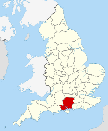
Hampshire shown in England
There are over 9000 Grade I listed buildings in England. This page is a list of the 215 Grade I listed buildings in the county of Hampshire. There are also five Grade I listed parks and gardens which are nota listed here.
Basingstoke and Deane[]
| Name | Location | Type | Completed [note 1] | Date designated | Grid ref.[note 2] Geo-coordinates |
Entry number [note 3] | Image |
|---|---|---|---|---|---|---|---|
| Church of St James | Ashmansworth, Basingstoke and Deane | Church | 12th century | 16 May 1966 | SU4107156631 51°18′26″N 1°24′44″W / 51.307321°N 1.412189°W |
1092445 |  |
| Church of St Catherine | Wolverton, Hampshire | Church | Medieval | 16 May 1966 | SU5518658564 51°19′25″N 1°12′34″W / 51.32351°N 1.209417°W |
1092569 |  |
| Church of St James | Bramley, Hampshire | Church | ALL PERIODS | 26 April 1957 | SU6449458988 51°19′35″N 1°04′33″W / 51.326345°N 1.07578°W |
1093029 |  |
| Barn Approximately 40 Metres South West of Manor Farmhouse | Old Burghclere, Burghclere, Basingstoke and Deane | Threshing Barn | 1451-3 | 18 May 1984 | SU4689157966 51°19′08″N 1°19′43″W / 51.318876°N 1.328527°W |
1157463 | 
|
| Church of All Saints | Old Burghclere, Burghclere, Basingstoke and Deane | Church | c. 1100 | 16 May 1966 | SU4684757868 51°19′05″N 1°19′45″W / 51.317999°N 1.329171°W |
1157301 |  |
| Sandham Memorial Chapel | Harts Lane, Burghclere, Basingstoke and Deane | Almshouse | 1926 | 18 May 1984 | SU4632960830 51°20′41″N 1°20′10″W / 51.344673°N 1.336219°W |
1339741 |  |
| Church of All Saints | Dummer, Hampshire | Church | c. 1200 | 26 April 1957 | SU5885646017 51°12′37″N 1°09′32″W / 51.210335°N 1.158817°W |
1093019 |  |
| Church of All Saints | Hannington, Hampshire | Church | Saxon | 16 May 1966 | SU5385855430 51°17′44″N 1°13′44″W / 51.295459°N 1.228946°W |
1339767 |  |
| Church of St Mary the Blessed Virgin | Hartley Wespall, Basingstoke and Deane | Church | 14th century | 26 April 1957 | SU6978458315 51°19′11″N 1°00′00″W / 51.319671°N 1.000002°W |
1339496 |  |
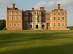
| Highclere Castle | Highclere Park, Highclere, Basingstoke and Deane | Country House | 1839-42 | 10 January 1953 | SU4463358796 51°19′35″N 1°21′39″W / 51.32652°N 1.360822°W |
1092528 |  |
| Jackdaws Castle | Highclere Park, Highclere, Basingstoke and Deane | Folly | c. 1740 | 16 May 1966 | SU4490558796 51°19′35″N 1°21′25″W / 51.326499°N 1.356919°W |
1092530 |  |
| Milford Lake House | Highclere Park, Highclere, Basingstoke and Deane | Summerhouse | Early 18th century | 16 May 1966 | SU4502460958 51°20′45″N 1°21′18″W / 51.345928°N 1.354938°W |
1092532 |
|
| Church of St Mary | Tufton, Hampshire | Church | Saxon | 16 May 1966 | SU4575046814 51°13′07″N 1°20′47″W / 51.218698°N 1.346322°W |
1175684 |  |
| Church of St Nicholas | Freefolk, Laverstoke, Basingstoke and Deane | Church | late medieval | 16 May 1966 | SU4874048609 51°14′05″N 1°18′12″W / 51.234591°N 1.30327°W |
1092725 |  |
| Priory Farmhouse | Mapledurwell and Up Nately, Basingstoke and Deane | Farmhouse | 17th century | 26 April 1957 | SU6885452557 51°16′05″N 1°00′52″W / 51.268017°N 1.014454°W |
1339548 |
|
| Church of All Saints | Monk Sherborne, Basingstoke and Deane | Church | c. 1140 | 26 April 1957 | SU6083555798 51°17′53″N 1°07′44″W / 51.298067°N 1.12883°W |
1339517 |  |
| Pamber Priory Church of the Holy Trinity, Our Lady, and St John the Baptist | Monk Sherborne, Basingstoke and Deane | Church | 1843 | 26 April 1957 | SU6089158156 51°19′09″N 1°07′39″W / 51.319261°N 1.127625°W |
1092954 |  |
| Church of St Swithin | Nately Scures, Newnham, Basingstoke and Deane | Church | 12th century | 26 April 1957 | SU6968253004 51°16′19″N 1°00′09″W / 51.271935°N 1.002501°W |
1092926 |  |
| Church of St Mary | Old Basing and Lychpit, Basingstoke and Deane | Church | Norman | 26 April 1957 | SU6659752927 51°16′18″N 1°02′48″W / 51.271611°N 1.046731°W |
1339555 |  |
| Tithe Barn | Old Basing and Lychpit, Basingstoke and Deane | Tithe Barn | 16th century | 26 April 1957 | SU6612252798 51°16′14″N 1°03′13″W / 51.270507°N 1.053563°W |
1166768 |  |
| Berrydown Court House | Overton, Hampshire | House | 1897-8 | 10 January 1977 | SU5260449485 51°14′32″N 1°14′52″W / 51.242125°N 1.247802°W |
1302517 |
|
| Entrance Lodge to Berrydown Court | Overton, Basingstoke and Deane | Carriageway | 10 January 1977 | SU5261949549 51°14′34″N 1°14′51″W / 51.242699°N 1.247578°W |
1302479 |
| |
| Walls to Kitchen Garden, Forecourt, and Roadside Boundary, with Garden Store Buildings, Berrydown Court | Overton, Basingstoke and Deane | Boundary Wall | 1897-8 | 12 April 1984 | SU5259849517 51°14′33″N 1°14′52″W / 51.242413°N 1.247883°W |
1092705 |
|
| Church of St. Andrew | Sherborne St John, Basingstoke and Deane | Church | c. 1150 | 26 April 1957 | SU6235855565 51°17′45″N 1°06′25″W / 51.295807°N 1.107029°W |
1339594 |  |
| The Vyne | Vyne Park, Sherborne St. John, Basingstoke and Deane | House | 1500–1520 | 26 April 1957 | SU6362756816 51°18′25″N 1°05′19″W / 51.306915°N 1.088608°W |
1296972 |  |
| Church of St. Mary | Silchester, Basingstoke and Deane | Church | 12th century | 26 April 1957 | SU6434162366 51°21′24″N 1°04′39″W / 51.356732°N 1.077366°W |
1339600 |  |
| Church of St Peter | St Mary Bourne, Basingstoke and Deane | Church | Norman | 16 May 1966 | SU4225450315 51°15′02″N 1°23′45″W / 51.250446°N 1.395964°W |
1092390 |  |
| Church of St. Mary the Virgin | Stratfield Saye, Basingstoke and Deane | Church | 1758 | 26 April 1957 | SU6956161387 51°20′50″N 1°00′09″W / 51.347316°N 1.002603°W |
1167723 |  |
| Stratfield Saye House | Stratfield Saye Park, Stratfield Saye, Basingstoke and Deane | House | 1640 | 26 April 1957 | SU7001861566 51°20′56″N 0°59′46″W / 51.34887°N 0.996007°W |
1092773 |  |
| Church of St Peter | Tadley, Basingstoke and Deane | Church | 17th century or Earlier | 16 May 1966 | SU5978559981 51°20′09″N 1°08′35″W / 51.335786°N 1.143188°W |
1092438 |  |
| Church of St Mary | Upton Grey, Basingstoke and Deane | Church | 12th century | 26 April 1957 | SU6975048447 51°13′51″N 1°00′09″W / 51.230957°N 1.002413°W |
1296652 | 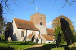 |
| Church of St Michael | Basingstoke and Deane | Church | 14th century | 3 May 1949 | SU6366452186 51°15′55″N 1°05′20″W / 51.265284°N 1.088901°W |
1092618 |  |
City of Portsmouth[]
| Name | Location | Type | Completed [note 1] | Date designated | Grid ref.[note 2] Geo-coordinates |
Entry number [note 3] | Image |
|---|---|---|---|---|---|---|---|
| 18 Gun Battery and Flanking Battery, Kings Stairs, Sallyport, Pointbarracks | The Point, City of Portsmouth | Gate | Late 17th century | 30 October 1969 | SZ6301599308 50°47′24″N 1°06′27″W / 50.789925°N 1.107378°W |
1386892 |  |
| Block Mill and Numbers 35 and 36 Stores (building Number 1/53) | Her Majesty's Naval Base, City of Portsmouth | Wall | 17th century | 13 August 1999 | SU6285800814 50°48′13″N 1°06′34″W / 50.803483°N 1.109348°W |
1078288 |  |
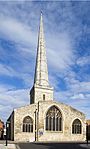
| Cathedral Church of St Thomas | Old Portsmouth, City of Portsmouth | Cathedral | 1927 | 10 January 1953 | SZ6323299381 50°47′26″N 1°06′15″W / 50.790558°N 1.104288°W |
1333198 | 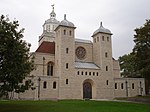 |
| Charles Dickens' Birthplace Museum | Landport, City of Portsmouth | House | Late 18th century | 10 January 1953 | SU6440801230 50°48′25″N 1°05′14″W / 50.807053°N 1.087282°W |
1103850 |  |
| Docks 1 to 6 (consecutive) Quay Walls and Bollards (including North and South Camber Mast Pond and Tunnel to Same) | Her Majesty's Naval Base, City of Portsmouth | Bollard | Mid 19th century | 13 August 1999 | SU6284300724 50°48′10″N 1°06′34″W / 50.802675°N 1.109576°W |
1272267 | 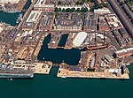 |
| Fort Southwick, That Part in Portsmouth Civil Parish | Paulsgrove, City of Portsmouth | Fort | c. 1860 | 30 October 1969 | SU6282306838 50°51′28″N 1°06′32″W / 50.857651°N 1.108814°W |
1104368 | 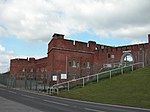 |
| Landport Gate | Portsea, Portsmouth | Town gate | 1760 | 18 March 1999 | SZ6346399717 50°47′37″N 1°06′03″W / 50.793553°N 1.100953°W |
1387159 |  |
| Number 10 Store (building Number 1/58) | Her Majesty's Naval Base, City of Portsmouth | Museum | c. 1991 | 13 August 1999 | SU6284700479 50°48′02″N 1°06′34″W / 50.800472°N 1.109561°W |
1272284 |  |
| Number 11 Store (building Number 1/59) | Her Majesty's Naval Base, City of Portsmouth | Library | 1999 | 13 August 1999 | SU6280700540 50°48′04″N 1°06′36″W / 50.801025°N 1.110118°W |
1272285 |
|
| Number 9 Store (building Number 1/35) | Her Majesty's Naval Base, City of Portsmouth | Naval storehouse | 1782 | 13 August 1999 | SU6288900409 50°47′59″N 1°06′32″W / 50.799838°N 1.108977°W |
1272283 | 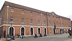 |
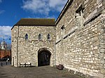
| The Round Tower | The Point, City of Portsmouth | Artillery tower | c. 1415 | 30 October 1969 | SZ6291199373 50°47′26″N 1°06′32″W / 50.79052°N 1.108842°W |
1386901 |  |
| The Square Tower | The Point, City of Portsmouth | Powder magazine | c. 1580 | 30 October 1969 | SZ6307699247 50°47′22″N 1°06′23″W / 50.78937°N 1.106523°W |
1386904 |  |
| Portsmouth Naval War Memorial | Southsea, City of Portsmouth | War memorial | 1924 | 23 May 2016 | SZ6385298495 50°46′57″N 1°05′44″W / 50.78252°N 1.09565°W |
1386975 |  |
City of Southampton[]


East Hampshire[]
| Name | Location | Type | Completed [note 1] | Date designated | Grid ref.[note 2] Geo-coordinates |
Entry number [note 3] | Image |
|---|---|---|---|---|---|---|---|
| Parish Church of St Lawrence | Alton, East Hampshire | Parish Church | Norman | 13 March 1951 | SU7172239602 51°09′04″N 0°58′33″W / 51.151192°N 0.975938°W |
1338903 |  |
| Church of the Holy Cross | Binsted, East Hampshire | Parish Church | Early 12th century | 31 July 1963 | SU7714240938 51°09′45″N 0°53′53″W / 51.162499°N 0.898175°W |
1302151 | 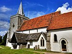 |
| West Court Barn | Binsted, East Hampshire | Barn | 1296–1304 | 15 August 1985 | SU7658541142 51°09′52″N 0°54′22″W / 51.16441°N 0.90610°W |
1338987 |
|
| Jane Austen's House | Chawton, East Hampshire | House | 18th century | 31 July 1963 | SU7083437579 51°07′59″N 0°59′21″W / 51.133115°N 0.989029°W |
1178917 |  |
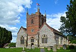
| All Saints Church, East Meon | East Meon, East Hampshire | Parish Church | Early 12th century | 16 March 1985 | SU6806222283 50°59′45″N 1°01′53″W / 50.995926°N 1.031514°W |
1351116 |  |
| The Court House | East Meon, East Hampshire | Farmhouse | Late 16th century | 16 March 1954 | SU6813122228 50°59′44″N 1°01′50″W / 50.995423°N 1.030541°W |
1094584 | 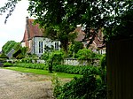 |
| Rotherfield Park | Rotherfield Park, East Tisted, East Hampshire | Country House | 1815-21 | 18 July 1986 | SU6947732305 51°05′09″N 1°00′34″W / 51.085863°N 1.009434°W |
1351139 |  |
| Church of St Mary of the Assumption | Upper Froyle, Froyle, East Hampshire | Parish Church | Early 14th century | 31 July 1963 | SU7556842870 51°10′48″N 0°55′13″W / 51.180079°N 0.920275°W |
1094095 |  |
| Church of the Holy Rood | Empshott, Hawkley, East Hampshire | Parish Church | 13th century | 16 March 1954 | SU7532831244 51°04′32″N 0°55′34″W / 51.075587°N 0.926134°W |
1094477 |  |
| Church of St Peter | Petersfield, East Hampshire | Church | 2nd quarter of 12th century | 29 July 1949 | SU7464823187 51°00′12″N 0°56′15″W / 51.003238°N 0.937496°W |
1157381 | 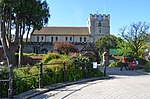 |
| Statue of William III | Petersfield, East Hampshire | Statue | 18th century | 29 July 1949 | SU7465123247 51°00′14″N 0°56′15″W / 51.003777°N 0.937441°W |
1093567 | 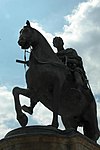 |
| St Huberts Chapel | Idsworth, Rowlands Castle, East Hampshire | Parish Church | 1053 | 16 March 1954 | SU7427914068 50°55′17″N 0°56′41″W / 50.921299°N 0.944613°W |
1094540 |  |
| Church of St Mary | The Plestor, Selborne, East Hampshire | Parish Church | c. 1180 | 3 July 1963 | SU7411933780 51°05′55″N 0°56′34″W / 51.098544°N 0.942869°W |
1351131 |  |
| The Wakes (including Museum Flat and the Flat) | Selborne, Selborne, East Hampshire | Apartment | 17th century | 31 July 1963 | SU7408333677 51°05′51″N 0°56′36″W / 51.097623°N 0.943404°W |
1174798 |  |
| Bedales Memorial Library, Lupton Hall and Corridor | Steep, East Hampshire | School Library | 1922 | 16 March 1954 | SU7428925132 51°01′15″N 0°56′32″W / 51.020772°N 0.942214°W |
1278033 |  |
| Church of St James | Upper Wield, Wield, East Hampshire | Cross | c. 1150 | 31 July 1963 | SU6284138753 51°08′41″N 1°06′11″W / 51.144601°N 1.103044°W |
1094078 |  |
Fareham[]
| Name | Location | Type | Completed [note 1] | Date designated | Grid ref.[note 2] Geo-coordinates |
Entry number [note 3] | Image |
|---|---|---|---|---|---|---|---|
| Church of St Mary | Portchester, Fareham | Church | 1710 | 18 October 1955 | SU6253004495 50°50′12″N 1°06′48″W / 50.836616°N 1.113376°W |
1339235 |  |
| Monastic Barn of Titchfield Abbey at Fern Hill Farm | Titchfield, Fareham | Tithe Barn | 15th century | 18 October 1955 | SU5395106489 50°51′19″N 1°14′06″W / 50.855407°N 1.234901°W |
1094235 |
|
| Parish Church of St Peter | Titchfield, Fareham | Parish Church | Possible C8 origins | 18 October 1955 | SU5409305785 50°50′57″N 1°13′59″W / 50.849064°N 1.232988°W |
1351279 | 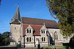 |
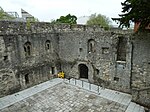
| Portchester Castle | Portchester, Fareham | Castle | During reign of Henry II | 18 October 1955 | SU6241104667 50°50′17″N 1°06′54″W / 50.838175°N 1.115036°W |
1229190 | 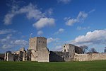 |
Gosport[]
| Name | Location | Type | Completed [note 1] | Date designated | Grid ref.[note 2] Geo-coordinates |
Entry number [note 3] | Image |
|---|---|---|---|---|---|---|---|
| 'A' Magazine, Museum Buildings | Gosport | Boundary wall | 1770 to 1776 | 19 January 1990 | SU6164101237 50°48′27″N 1°07′36″W / 50.807417°N 1.126545°W |
1276026 | 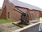 |
| 'B' Magazine (north and south Stores) and attached Passage and Boundary Wall, and Main Rolling Way and Attached Foreman's Office | Gosport | Cooperage | 1773 | 19 January 1990 | SU6165501256 50°48′27″N 1°07′35″W / 50.807586°N 1.126344°W |
1393247 |  |
| Gunboat Sheds and Workshops | Gosport | Sheds and workshops | 1856 | 14 June 2016 | SZ6172198973 50°47′13″N 1°07′33″W / 50.78705°N 1.12579°W |
1431190 |
|
| Church of St Mary | Rowner, Gosport | Church | 13th century | 20 April 1983 | SU5840801634 50°48′41″N 1°10′20″W / 50.811321°N 1.172361°W |
1276419 | 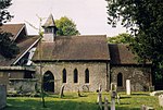 |
Hart[]


Havant[]
| Name | Location | Type | Completed [note 1] | Date designated | Grid ref.[note 2] Geo-coordinates |
Entry number [note 3] | Image |
|---|---|---|---|---|---|---|---|
| Church of St Peter | Hayling Island, Havant | Parish Church | Transitional | 16 May 1952 | SU7308703201 50°49′25″N 0°57′49″W / 50.823747°N 0.963737°W |
1155352 |  |
| Church of St Thomas à Becket | Warblington, Havant | Parish Church | Saxon | 16 May 1952 | SU7290005418 50°50′37″N 0°57′57″W / 50.843703°N 0.965951°W |
1154443 |  |
New Forest[]
| Name | Location | Type | Completed [note 1] | Date designated | Grid ref.[note 2] Geo-coordinates |
Entry number [note 3] | Image |
|---|---|---|---|---|---|---|---|
| Church of the Blessed Virgin and Child | Beaulieu, Hampshire | Church | Early/Mid 13th century | 8 October 1959 | SU3883202548 50°49′16″N 1°27′00″W / 50.821179°N 1.450097°W |
1156943 |  |
| Domus and Ruins of Lay Frater | Beaulieu Manor Estate, Beaulieu, New Forest | Abbey | Late 13th century | 8 October 1959 | SU3879602579 50°49′17″N 1°27′02″W / 50.82146°N 1.450604°W |
1156631 |  |
| Palace House | Beaulieu Manor Estate, Beaulieu, New Forest | Abbey | Mid 14th century | 8 October 1959 | SU3873002445 50°49′13″N 1°27′06″W / 50.82026°N 1.451555°W |
1094430 |  |
| Remains of Outer Wall Around Cloister and Foundations of Abbey Church | Beaulieu Manor Estate, Beaulieu, New Forest | Abbey | Late 13th century | 8 October 1959 | SU3883002591 50°49′18″N 1°27′00″W / 50.821566°N 1.45012°W |
1094429 |  |
| Remains of St Leonard's Chapel | St Leonard's, Beaulieu, New Forest | Chapel | 14th century | 8 October 1959 | SZ4052798207 50°46′55″N 1°25′35″W / 50.782029°N 1.426513°W |
1094415 |  |
| St Leonard's Barn | St Leonard's, Beaulieu, New Forest | Barn | 14th century | 8 October 1959 | SZ4064898164 50°46′54″N 1°25′29″W / 50.781633°N 1.424801°W |
1157008 |  |
| Hinton Admiral House | Hinton Park, Bransgore, New Forest | Country House | 1720 | 30 September 1964 | SZ2085395944 50°45′46″N 1°42′21″W / 50.762716°N 1.7057°W |
1095030 |  |
| Church of St Mary | Breamore Park, Breamore, New Forest | Parish Church | Late 10th century | 30 September 1964 | SU1532818896 50°58′09″N 1°46′59″W / 50.96928°N 1.783081°W |
1094934 |  |
| Church of St George | Damerham, New Forest | Parish Church | 12th century | 13 February 1987 | SU1075315809 50°56′30″N 1°50′54″W / 50.941624°N 1.848326°W |
1094925 | 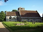 |
| Church of St Mary | Ellingham, Hampshire | Parish Church | 13th century | 30 September 1964 | SU1442508323 50°52′27″N 1°47′47″W / 50.874228°N 1.796356°W |
1156533 |  |
| Church of All Saints | Fawley, Hampshire | Tower | c. 1175 | 8 October 1959 | SU4575403553 50°49′47″N 1°21′06″W / 50.829712°N 1.351711°W |
1351239 |  |
| Church of St Mary | Fordingbridge, New Forest | Parish Church | 12th century | 30 September 1964 | SU1451513813 50°55′25″N 1°47′41″W / 50.923594°N 1.79486°W |
1350974 |  |
| Church of St Mary | Hale Park, Hale, Hampshire | Parish Church | Medieval origins | 30 September 1964 | SU1784218655 50°58′01″N 1°44′50″W / 50.967041°N 1.747291°W |
1094881 |  |
| Hale House, Including Quadrant Passages to Pavilions | Hale Park, Hale, New Forest | Country House | 1715 | 30 April 1955 | SU1794718577 50°57′59″N 1°44′45″W / 50.966337°N 1.745799°W |
1301070 | 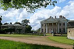 |
| Church of St Michael and All Angels | Lyndhurst, Hampshire | Parish Church | 1858-68 | 13 May 1987 | SU2980508168 50°52′20″N 1°34′40″W / 50.872249°N 1.577787°W |
1094725 |  |
| Church of All Saints | Martin, Hampshire | Parish Church | 12th century | 30 September 1964 | SU0705019559 50°58′31″N 1°54′03″W / 50.975401°N 1.900958°W |
1094828 |  |
| Church of All Saints | Milford-on-Sea, New Forest | Church | late Norman | 22 December 1973 | SZ2905592109 50°43′40″N 1°35′23″W / 50.727879°N 1.589711°W |
1276161 |  |
| Church of All Saints | Minstead, New Forest | Church | Early 19th century | 8 October 1959 | SU2810510878 50°53′48″N 1°36′06″W / 50.896702°N 1.601739°W |
1094732 |  |
| Barn Formerly Chapel 20 Metres East of Manor House | Manor Farm, Rockbourne, New Forest | Chapel | 13th century | 30 September 1964 | SU1156318371 50°57′53″N 1°50′12″W / 50.964647°N 1.836716°W |
1167857 |  |
| Church of St Andrew | Manor Farm, Rockbourne, New Forest | Parish Church | 13th century | 30 September 1964 | SU1155818319 50°57′51″N 1°50′12″W / 50.964179°N 1.836789°W |
1296677 |  |
| Large Barn 50 Metres North East of Manor House | Manor Farm, Rockbourne, New Forest | House | 15th century | 30 September 1964 | SU1155818395 50°57′54″N 1°50′12″W / 50.964863°N 1.836787°W |
1351003 |  |
| Manor Farm and Wall Running North East | Manor Farm, Rockbourne, New Forest | Hall House | 14th century | 30 September 1964 | SU1153418341 50°57′52″N 1°50′14″W / 50.964377°N 1.83713°W |
1351002 |  |
| Avon Tyrrell House | Avon Tyrrell, Sopley, New Forest | Country House | 1891 | 12 March 1987 | SU1853100257 50°48′06″N 1°44′18″W / 50.801579°N 1.738406°W |
1350922 |  |
| Church of All Saints | Thorney Hill, Sopley, New Forest | Church | 1906 | 24 September 1985 | SZ1970099724 50°47′48″N 1°43′19″W / 50.796748°N 1.721846°W |
1302198 |  |
Rushmoor[]
| Name | Location | Type | Completed [note 1] | Date designated | Grid ref.[note 2] Geo-coordinates |
Entry number [note 3] | Image |
|---|---|---|---|---|---|---|---|
| Abbey Church of St Michael | Rushmoor | Church | 1886-7 | 28 January 1959 | SU8727856078 51°17′50″N 0°44′58″W / 51.29715°N 0.749572°W |
1155639 |  |
| Building Q121 at Former Royal Aircraft Establishment Site | Rushmoor | Workshop | 1934–1935 | 4 December 1996 | SU8678754709 51°17′06″N 0°45′25″W / 51.284918°N 0.756945°W |
1259589 |  |
| Building R133 at Former Royal Aircraft Establishment site | Rushmoor | Test House | 1939–1942 | 4 December 1996 | SU8686154824 51°17′09″N 0°45′21″W / 51.28594°N 0.755856°W |
1259586 |  |
| Main Building to Farnborough Hill Convent | Rushmoor | House | 1863 | 13 November 1975 | SU8718856449 51°18′02″N 0°45′03″W / 51.300498°N 0.750772°W |
1303116 |  |
Test Valley[]
| Name | Location | Type | Completed [note 1] | Date designated | Grid ref.[note 2] Geo-coordinates |
Entry number [note 3] | Image |
|---|---|---|---|---|---|---|---|
| Church of St Mary the Virgin | Abbotts Ann, Test Valley | Parish Church | 1716 | 20 December 1960 | SU3304343575 51°11′26″N 1°31′43″W / 51.190449°N 1.528553°W |
1228703 |  |
| Church of St Mary the Less | Chilbolton, Test Valley | Parish Church | Norman | 20 December 1960 | SU3948140219 51°09′36″N 1°26′12″W / 51.159866°N 1.436801°W |
1339283 |  |
| Church of St Michael and All Angels | Knights Enham, Enham Alamein, Test Valley | Church | Norman | 24 February 1950 | SU3618048075 51°13′51″N 1°29′00″W / 51.230722°N 1.483214°W |
1093461 | 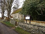 |
| Church of St Peter | Goodworth Clatford, Test Valley | Parish Church | Norman | 20 December 1960 | SU3661542533 51°10′51″N 1°28′39″W / 51.180863°N 1.477548°W |
1339285 |  |
| Church of St Leonard | Grateley, Test Valley | Parish Church | Norman | 24 October 1984 | SU2756241970 51°10′35″N 1°36′26″W / 51.176307°N 1.607104°W |
1093259 |  |
| Church of St Peter | Hurstbourne Tarrant, Test Valley | Parish Church | Late 12th century | 20 December 1960 | SU3852452990 51°16′29″N 1°26′57″W / 51.274761°N 1.449117°W |
1093367 |  |
| Church of St Peter and St Paul | Kimpton, Hampshire | Church | 13th century | 21 December 1960 | SU2811446625 51°13′05″N 1°35′56″W / 51.218136°N 1.598845°W |
1093222 |  |
| Marshcourt School | Marsh Court, King's Somborne, Test Valley | Country House | 1901–5 | 29 May 1957 | SU3566033594 51°06′02″N 1°29′32″W / 51.100546°N 1.492092°W |
1093803 |  |
| Church of St Nicholas | Middleton, Longparish, Test Valley | Parish Church | c. 1200 | 20 December 1960 | SU4257043907 51°11′34″N 1°23′32″W / 51.192806°N 1.392195°W |
1339297 |  |
| Church of St Andrew | Mottisfont, Test Valley | Parish Church | 12th century | 29 May 1957 | SU3259426749 51°02′21″N 1°32′11″W / 51.039179°N 1.536493°W |
1172913 |  |
| Mottisfont Abbey House | Mottisfont Abbey, Mottisfont, Test Valley | Country House | 16th century | 29 May 1957 | SU3270426965 51°02′28″N 1°32′06″W / 51.041115°N 1.534905°W |
1093730 |  |
| Barn 40 Metres East of Berry Court Farmhouse | Nether Wallop, Test Valley | Farmyard | 15th century | 27 November 1984 | SU3023735638 51°07′09″N 1°34′10″W / 51.119236°N 1.569369°W |
1339452 |
|
| Church of St Andrew | Nether Wallop, Test Valley | Parish Church | 11th century | 29 May 1957 | SU3039636398 51°07′34″N 1°34′01″W / 51.126062°N 1.567033°W |
1339423 |  |
| Grove Place House, Northcliffe School | Grove Place, Nursling and Rownhams, Test Valley | Country House | Mid 16th century | 29 May 1957 | SU3668016759 50°56′57″N 1°28′45″W / 50.949105°N 1.479224°W |
1339157 |  |
| Abbey Church of St Mary | Romsey, Test Valley | Abbey | until circa 1230 | 28 August 1951 | SU3509321257 50°59′23″N 1°30′05″W / 50.989649°N 1.501382°W |
1092649 | 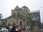 |
| King John's House | Romsey, Test Valley | Abbey | Medieval | 28 August 1951 | SU3521921280 50°59′23″N 1°29′59″W / 50.989848°N 1.499584°W |
1231745 | 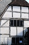 |
| Broadlands House | Broadlands Estate, Romsey Extra, Test Valley | Country House | Elizabethan | 29 May 1957 | SU3539120242 50°58′50″N 1°29′50″W / 50.980504°N 1.497234°W |
1166489 | 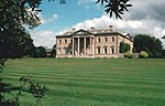 |
| Middle Bridge | Romsey Extra, Test Valley | Bridge | 1788 | 28 August 1951 | SU3492220680 50°59′04″N 1°30′14″W / 50.984471°N 1.503873°W |
1339680 |  |
| Church of St Peter and St Paul | Thruxton, Hampshire | Parish Church | 13th century | 20 December 1960 | SU2888445588 51°12′32″N 1°35′16″W / 51.208774°N 1.587903°W |
1093204 |  |
| Church of St Margaret | Wellow, Hampshire | Parish Church | Early 13th century | 29 May 1957 | SU3028620397 50°58′56″N 1°34′12″W / 50.982188°N 1.569939°W |
1339214 |  |
| Stable Block (30 Yards South of Wherwell Priory) | Wherwell, Test Valley | Abbey | 2nd quarter of 13th century | 21 March 1984 | SU3917740671 51°09′50″N 1°26′28″W / 51.163951°N 1.441099°W |
1093391 |
|
Winchester[]
| Name | Location | Type | Completed [note 1] | Date designated | Grid ref.[note 2] Geo-coordinates |
Entry number [note 3] | Image |
|---|---|---|---|---|---|---|---|
| Church of All Saints | Bighton, Winchester | Parish Church | 12th century | 5 December 1955 | SU6101634481 51°06′23″N 1°07′47″W / 51.106389°N 1.129851°W |
1155172 |  |
| Church of St Nicholas | Bishops Sutton, Winchester | Parish Church | 12th century | 5 December 1955 | SU6059932016 51°05′03″N 1°08′10″W / 51.08427°N 1.13622°W |
1350825 |  |
| Church of St Nicholas | Boarhunt, Winchester | Parish Church | c. 1064 | 6 March 1967 | SU6034008281 50°52′15″N 1°08′38″W / 50.87089°N 1.143849°W |
1350613 |  |
| Fort Nelson | Fort Nelson, Boarhunt, Winchester | Fort | 1860s | 22 December 1971 | SU6069607203 50°51′40″N 1°08′20″W / 50.86116°N 1.138969°W |
1350616 |  |
| Church of St Michael | Cheriton, Hampshire | Church | 13th century | 5 December 1955 | SU5819328474 51°03′10″N 1°10′16″W / 51.052672°N 1.171135°W |
1303010 |  |
| Church of St Andrew | Chilcomb, Winchester | Parish Church | 1120-40 | 5 December 1955 | SU5071627919 51°02′54″N 1°16′40″W / 51.048389°N 1.277877°W |
1095907 |  |
| Corhampton Church | Corhampton, Winchester | Parish Church | c. 1020 | 6 March 1967 | SU6100120323 50°58′45″N 1°07′57″W / 50.979094°N 1.132446°W |
1179686 |  |
| Church of St Mary and All Saints | Droxford, Winchester | Parish Church | Norman | 6 March 1967 | SU6077418210 50°57′36″N 1°08′10″W / 50.960119°N 1.136031°W |
1095540 |  |
| Church of St Peter and St Paul | Hambledon, Hampshire | Parish Church | Saxon | 24 September 1987 | SU6463315180 50°55′57″N 1°04′54″W / 50.932457°N 1.081629°W |
1301325 |  |
| Church of St Swithun | Headbourne Worthy, Winchester | Parish Church | Saxon | 5 December 1955 | SU4874031991 51°05′07″N 1°18′20″W / 51.085173°N 1.305516°W |
1350461 |  |
| Church of St John | Hursley, Winchester | Church | 12th century | 27 November 1984 | SU3973127443 51°02′42″N 1°26′05″W / 51.044972°N 1.434629°W |
1178648 |  |
| Cranbury House | Cranbury Park, Hursley, Winchester | Country House | 1790 | 27 November 1984 | SU4462523242 51°00′25″N 1°21′55″W / 51.006839°N 1.365338°W |
1095809 |  |
| Avington House | Avington, Hampshire | Country House | Late 16th century | 5 December 1955 | SU5325532323 51°05′16″N 1°14′28″W / 51.087758°N 1.241013°W |
1095887 | 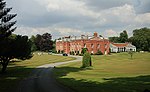 |
| Church of St Mary | Easton, Hampshire | Parish Church | c. 1200 | 5 December 1955 | SU5091332258 51°05′15″N 1°16′28″W / 51.087385°N 1.274458°W |
1095898 |  |
| Church of St Mary | Avington, Hampshire | Parish Church | 1768-71 | 5 December 1955 | SU5328832252 51°05′14″N 1°14′26″W / 51.087116°N 1.240552°W |
1350483 | 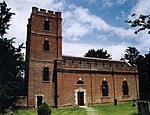 |
| The Grange | Grange Park, Northington, Winchester | Country House | 1670-3 | 5 December 1955 | SU5622136154 51°07′19″N 1°11′53″W / 51.12192°N 1.198073°W |
1095216 |  |
| Godsfield Chapel adjacent to Godsfield Farmhouse | Old Alresford, Winchester | House | Late 14th century | 16 November 1983 | SU6043137048 51°07′46″N 1°08′16″W / 51.129531°N 1.137777°W |
1350808 |
|
| Marwell Hall | Marwell Zoo Park, Owslebury, Winchester | Country House | 14th century | 5 December 1955 | SU5085821779 50°59′35″N 1°16′36″W / 50.993169°N 1.276711°W |
1350871 |  |
| New Place, Shirrell Heath | Shedfield, Winchester | Country House | 1906 | 3 February 1952 | SU5665813537 50°55′07″N 1°11′43″W / 50.918521°N 1.195357°W |
1095660 |  |
| Church of St Peter | Soberton, Winchester | Parish Church | Norman | 6 March 1967 | SU6108216840 50°56′52″N 1°07′55″W / 50.947769°N 1.131876°W |
1166968 |  |
| Church of St James Without the Priory Gate | Southwick, Hampshire | Church | Earlier | 6 March 1967 | SU6259408644 50°52′26″N 1°06′42″W / 50.873914°N 1.111759°W |
1167160 |  |
| Fort Southwick | Portsdown Hill, Southwick and Widley, Winchester | Fort | 1860s | 24 September 1987 | SU6287306997 50°51′33″N 1°06′29″W / 50.859075°N 1.108077°W |
1167213 | |
| Church of St Andrew | Tichborne, Winchester | Parish Church | Mid 11th century | 5 December 1955 | SU5687230259 51°04′08″N 1°11′23″W / 51.068853°N 1.189699°W |
1178485 |  |
| Church of Our Lady | Warnford, Winchester | Parish Church | Saxon | 6 March 1967 | SU6225122659 51°00′00″N 1°06′51″W / 50.999964°N 1.114243°W |
1296978 |  |
| St John's House | Warnford, Winchester | Aisled House | 13th century | 6 March 1967 | SU6229622647 50°59′59″N 1°06′49″W / 50.999851°N 1.113604°W |
1350308 |  |
| Church of St Michael | Stoke Charity, Wonston, Winchester | Parish Church | c. 1190 | 5 December 1955 | SU4887839271 51°09′02″N 1°18′09″W / 51.150619°N 1.302562°W |
1302427 |  |
| Avebury House | Winchester | House | 1690 | 24 March 1950 | SU4808829614 51°03′50″N 1°18′55″W / 51.063855°N 1.31514°W |
1173668 |  |
| Cart Shed to West of Hyde Abbey Gateway and adjoining it | Winchester | Cart Shed | 12th century | 14 January 1974 | SU4814630142 51°04′07″N 1°18′51″W / 51.068598°N 1.314242°W |
1296399 |  |
| Cathedral Church of the Holy Trinity | Winchester | Chapter House | Norman | 24 March 1950 | SU4822129254 51°03′38″N 1°18′48″W / 51.060607°N 1.31329°W |
1095509 |  |
| Cheyney Court | Winchester | Timber Framed House | 15th century | 24 March 1950 | SU4817529079 51°03′33″N 1°18′50″W / 51.059037°N 1.313969°W |
1095517 |  |
| Porter's Lodge | Winchester | Lodge | 15th century | 24 March 1950 | SU4816729084 51°03′33″N 1°18′51″W / 51.059083°N 1.314083°W |
1296925 |  |
| Church of St John the Baptist | Winchester | Church | c. 1200 | 14 January 1974 | SU4870129446 51°03′44″N 1°18′23″W / 51.062293°N 1.306415°W |
1296158 |  |
| City Bridge | Winchester | Bridge | 1813 | 24 March 1950 | SU4860229298 51°03′39″N 1°18′28″W / 51.060971°N 1.307848°W |
1167781 | 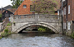 |
| School - St Mary's College | Winchester | School | 1692 | 24 March 1950 | SU4821828918 51°03′27″N 1°18′48″W / 51.057586°N 1.313377°W |
1167544 |
|
| Sick House, St Mary's College | Winchester | School | 1656 | 24 March 1950 | SU4811328837 51°03′25″N 1°18′54″W / 51.056867°N 1.314886°W |
1350685 |
|
| Warden's Lodgings, St Mary's College | Winchester | House | Late 14th century | 24 March 1950 | SU4828028967 51°03′29″N 1°18′45″W / 51.058022°N 1.312486°W |
1167489 |
|
| Chapel, St Mary's College | Winchester | School | Late 14th century | 24 March 1950 | SU4825928940 51°03′28″N 1°18′46″W / 51.057781°N 1.312789°W |
1350684 | 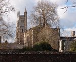 |
| Chamber Court with Middle Gate, St Mary's College | Winchester | Tower | 1387 | 24 March 1950 | SU4823928980 51°03′29″N 1°18′47″W / 51.058142°N 1.313069°W |
1296879 |  |
| Cloisters, St Mary's College | Winchester | School | Late 14th century | 24 March 1950 | SU4823528913 51°03′27″N 1°18′47″W / 51.05754°N 1.313135°W |
1296887 |
|
| College Hall, St Mary's College | Winchester | School Hall | Late 14th century | 24 March 1950 | SU4822828950 51°03′28″N 1°18′48″W / 51.057873°N 1.31323°W |
1095484 |
|
| Outer Court with Outer Gate, St Mary's College | Winchester | Gate | Late 14th century | 24 March 1950 | SU4825029013 51°03′30″N 1°18′46″W / 51.058438°N 1.312908°W |
1095483 |  |
| Fromond's Chantry, St Mary's College | Winchester | School | 15th century | 24 March 1950 | SU4825128910 51°03′27″N 1°18′46″W / 51.057511°N 1.312907°W |
1095485 |
|
| Close Boundary Walls and Gates, Priors Gate | Winchester | Gate | 15th century | 24 March 1950 | SU4814229184 51°03′36″N 1°18′52″W / 51.059984°N 1.314426°W |
1095512 |  |
| Dome Alley | The Close, Winchester | House | Built soon after 1660 | 24 March 1950 | SU4751629417 51°03′44″N 1°19′24″W / 51.062131°N 1.323328°W |
1095518 |
|
| Great Hall, Winchester Castle | Winchester | Castle | 1232–1240 | 24 March 1950 | SU4776729477 51°03′46″N 1°19′11″W / 51.06265°N 1.319738°W |
1351065 |  |
| Hospital of St Cross and Almshouses of Noble Poverty | Winchester | Courtyard | 1136 | 24 March 1950 | SU4760727750 51°02′50″N 1°19′20″W / 51.047135°N 1.322248°W |
1095374 | 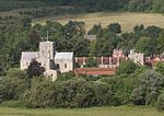 |
| Hyde Abbey Gateway | Winchester | Gate | 15th century | 24 March 1950 | SU4816030131 51°04′07″N 1°18′51″W / 51.068498°N 1.314044°W |
1095419 |  |
| The Church of St Swithun Upon Kingsgate | Winchester | Church [note 4] |
14th century | 24 March 1950 | SU4814429092 51°03′33″N 1°18′52″W / 51.059157°N 1.31441°W |
1095355 |  |
| Minster House | Winchester | House | Early 18th century | 24 March 1950 | SU4805629355 51°03′42″N 1°18′56″W / 51.061529°N 1.315631°W |
1350671 |  |
| Garden Wall to the South of Minster House on the East and South Sides of the Garden | Winchester | Garden Wall | 18th century | 14 January 1974 | SU4805929320 51°03′40″N 1°18′56″W / 51.061214°N 1.315592°W |
1095459 |
|
| Part of the City, Palace and Castle Wall Running East from Priory Gate to Angle near to Hall above Magdalen Hospital | City Wall, Winchester | Gate | 13th century | 24 March 1950 | SU4858529256 51°03′38″N 1°18′29″W / 51.060594°N 1.308096°W |
1095505 |
|
| Pilgrims' Hall | Winchester | Meeting Hall | 13th century to 14th century | 24 March 1950 | SU4825029108 51°03′33″N 1°18′46″W / 51.059292°N 1.312895°W |
1095516 | 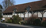 |
| Pilgrims' School | Winchester | School | Late 17th century to early 18th century | 24 March 1950 | SU4823229083 51°03′33″N 1°18′47″W / 51.059069°N 1.313156°W |
1167387 | 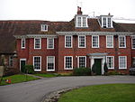 |
| St John's Rooms and Chapel | Winchester | Chapel | 13th century | 24 March 1950 | SU4849229361 51°03′42″N 1°18′34″W / 51.061546°N 1.309409°W |
1095441 | 
|
| The Carnery | Winchester | Charnel House | 14th century | 24 March 1950 | SU4811229288 51°03′39″N 1°18′53″W / 51.060922°N 1.31484°W |
1350679 |
|
| The Deanery, Incorporating Prior's Hall | Winchester | Deanery | 14th century to 15th century | 24 March 1950 | SU4820929173 51°03′36″N 1°18′48″W / 51.05988°N 1.313472°W |
1095514 |  |
| The Judge's Lodging | Winchester | House | Late 17th century to early 18th century | 24 March 1950 | SU4817029132 51°03′34″N 1°18′51″W / 51.059514°N 1.314034°W |
1350657 |
|
| The Old Stables | Winchester | Stable | Probably Early 16th century | 24 March 1950 | SU4819029089 51°03′33″N 1°18′50″W / 51.059126°N 1.313754°W |
1350656 |
|
| War Cloister, Winchester College | Winchester | War memorial | 1924 | 24 March 1950 | SU4811928905 51°03′27″N 1°18′53″W / 51.057478°N 1.3147914°W |
1095486 | |
| The Westgate | Winchester | Gate | 13th century | 24 March 1950 | SU4781229576 51°03′49″N 1°19′09″W / 51.063536°N 1.319083°W |
1350695 |  |
| Wolvesey Castle | Winchester | Bishops Palace | 1129–1171 | 24 March 1950 | SU4845929088 51°03′33″N 1°18′36″W / 51.059094°N 1.309916°W |
1095511 |  |
| Wolvesey Palace | Winchester | Bishops Palace | 1684 | 24 March 1950 | SU4840329068 51°03′32″N 1°18′39″W / 51.058919°N 1.310718°W |
1095510 |  |
| No 4 St Peter Street | Winchester | House | 17th century | 14 January 1974 | SU4807529575 51°03′49″N 1°18′55″W / 51.063506°N 1.31533°W |
1095390 | |
| No 1 The Close | Winchester | House | 1699 | 24 March 1950 | SU4827429204 51°03′37″N 1°18′45″W / 51.060153°N 1.31254°W |
1095513 |
|
| No. 9 The Close | Winchester | House | Early 17th century | 24 March 1950 | SU4813829168 51°03′35″N 1°18′52″W / 51.059841°N 1.314485°W |
1350677 | 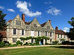 |
| No. 10 The Close | Winchester | House | 18th century | 24 March 1950 | SU4814329211 51°03′37″N 1°18′52″W / 51.060227°N 1.314408°W |
1095475 |
|
| No. 11 The Close | Winchester | House | mid/Late 17th century | 24 March 1950 | SU4812129266 51°03′39″N 1°18′53″W / 51.060723°N 1.314715°W |
1350678 |  |
See also[]
- Category:Grade I listed buildings in Hampshire
- Grade II* listed buildings in Hampshire
Notes[]
- ^ a b c d e f g h i j k l The date given is the date used by Historic England as significant for the initial building or that of an important part in the structure's description.
- ^ a b c d e f g h i j k l Sometimes known as OSGB36, the grid reference is based on the British national grid reference system used by the Ordnance Survey.
- ^ a b c d e f g h i j k l The "List Entry Number" is a unique number assigned to each listed building and scheduled monument by Historic England.
- ^ Kingsgate is a scheduled monument. The church above the gate is a Grade I listed building.
References[]
National Heritage List for England
External links[]
![]() Media related to Grade I listed buildings in Hampshire at Wikimedia Commons
Media related to Grade I listed buildings in Hampshire at Wikimedia Commons
Categories:
- Grade I listed buildings in Hampshire
- Lists of Grade I listed buildings in Hampshire
- Lists of listed buildings in Hampshire