Greenwich (town), New York
Greenwich | |
|---|---|
Town | |
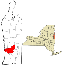 Location in Washington County and the state of New York. | |
| Coordinates: 43°07′54″N 73°28′38″W / 43.13167°N 73.47722°WCoordinates: 43°07′54″N 73°28′38″W / 43.13167°N 73.47722°W | |
| Country | United States |
| State | New York |
| County | Washington |
| Established | 1803 |
| Government | |
| • Town supervisor | Don Ward |
| Area | |
| • Total | 44.26 sq mi (114.64 km2) |
| • Land | 43.66 sq mi (113.09 km2) |
| • Water | 0.60 sq mi (1.55 km2) |
| Population | |
| • Total | 4,942 |
| • Estimate (2016)[5] | 4,842 |
| • Density | 110.89/sq mi (42.82/km2) |
| Time zone | UTC-5 (EST) |
| • Summer (DST) | UTC-4 |
| ZIP code(s)[4] | show
12834 (primary) |
| Area code(s) | 518 |
| FIPS code | 36-115-30686 |
| Website | http://www.greenwichny.org/ |

Greenwich is a town in the southwest part of Washington County, New York, United States. The town is located on the west border of the county. The population was 4,896 at the 2000 census.[3] It is part of the Glens Falls Metropolitan Statistical Area.[6] Greenwich features several homes that were a part of the Underground Railroad.[7]
The Town of Greenwich contains a village also named Greenwich.[7]
History[]
The Horicon tribe is believed to be part of the early native population of the town.[7]

Families began settling the area around 1763. The town was originally part of five land patents: Saratoga, Kettlehuyn, Cuyler, Campbell, and Argyle. The Town of Greenwich was formed from part of the Town of Argyle in 1803. In 1809, the community of Whipple City incorporated as a village and adopted the name Union Village. In 1867, the name was changed to Greenwich.[7]
Greenwich views itself as having been an important location along the Underground Railroad. A historical marker was placed in Mowry Park detailing the locations of former safe houses.[7]
The Greenwich and Johnsonville Railroad brought rail service to the area in 1870.[8]
The Coffin Site was listed on the National Register of Historic Places in 1980.[9]
Geography[]
According to the United States Census Bureau, the town has a total area of 44.4 square miles (114.9 km2), of which, 44.0 square miles (114.0 km2) of it is land and 0.4 square miles (0.9 km2) of it (0.81%) is water.
It lies within the Cambridge valley region in between the Adirondack Mountains and Green Mountain Range of Vermont.
The west town line is defined by the Hudson River with Saratoga County on the opposite shore.
New York State Route 40 (NY 40) is a north-south highway through the center of the town. NY 29 is an east-west highway located near the south town line and Batten Kill River. NY 40 and NY 29 join near Middle Falls.
Demographics[]
| Historical population | |||
|---|---|---|---|
| Census | Pop. | %± | |
| 1820 | 3,197 | — | |
| 1830 | 3,850 | 20.4% | |
| 1840 | 3,382 | −12.2% | |
| 1850 | 3,803 | 12.4% | |
| 1860 | 3,941 | 3.6% | |
| 1870 | 4,030 | 2.3% | |
| 1880 | 3,860 | −4.2% | |
| 1890 | 4,196 | 8.7% | |
| 1900 | 4,172 | −0.6% | |
| 1910 | 4,227 | 1.3% | |
| 1920 | 4,268 | 1.0% | |
| 1930 | 3,872 | −9.3% | |
| 1940 | 3,766 | −2.7% | |
| 1950 | 3,811 | 1.2% | |
| 1960 | 3,969 | 4.1% | |
| 1970 | 4,177 | 5.2% | |
| 1980 | 4,276 | 2.4% | |
| 1990 | 4,557 | 6.6% | |
| 2000 | 4,896 | 7.4% | |
| 2010 | 4,942 | 0.9% | |
| 2016 (est.) | 4,842 | [5] | −2.0% |
| U.S. Decennial Census[10] | |||

As of the census of 2000, there were 4,896 people, 1,927 households, and 1,358 families residing in the town. The population density was 111.3 people per square mile (43.0/km2). There were 2,101 housing units at an average density of 47.7 per square mile (18.4/km2). The racial makeup of the town was 97.81% White, 0.31% Black or African American, 0.06% Native American, 0.82% Asian, 0.04% Pacific Islander, 0.18% from other races, and 0.78% from two or more races. Hispanic or Latino of any race were 0.65% of the population.[3]
There were 1,927 households, out of which 33.0% had children under the age of 18 living with them, 56.5% were married couples living together, 9.1% had a female householder with no husband present, and 29.5% were non-families. 24.1% of all households were made up of individuals, and 12.0% had someone living alone who was 65 years of age or older. The average household size was 2.54 and the average family size was 3.01.[3]
In the town, the population was spread out, with 25.9% under the age of 18, 6.9% from 18 to 24, 27.7% from 25 to 44, 24.5% from 45 to 64, and 15.0% who were 65 years of age or older. The median age was 39 years. For every 100 females, there were 93.0 males. For every 100 females age 18 and over, there were 88.4 males.[3]
The median income for a household in the town was $39,138, and the median income for a family was $47,260. Males had a median income of $34,964 versus $26,629 for females. The per capita income for the town was $19,913. About 5.8% of families and 8.4% of the population were below the poverty line, including 7.5% of those under age 18 and 11.7% of those age 65 or over.[3]
Education[]
A majority of Greenwich falls within the Greenwich Central School District. The district has three school buildings on 108 acres (0.44 km2) of land. It serves around 1,300 students and employs 99 administrators and teachers. It was established in 1945 as a consolidation of rural school districts with the union free school district in Greenwich village.[11] Small areas of Greenwich fall within the Schuylerville, Argyle, and Salem Central school districts.[4] The school district is currently ranked #1,521 in the country according to U.S. News & World Report in 2014 earning a Silver medal award. [1] The school district is currently ranked #10 in the Capital District according to the Capital District Business Review. [2]
The Adirondack School of Northeastern New York provides private secondary education for grades 7 through 12.[12]
Notable people[]
- Susan B. Anthony - Women's rights activist spent her childhood in Greenwich.
- Chester A. Arthur - Lived in Greenwich for five years in his youth before becoming 21st President of the United States.
- John Lourie Beveridge - Born in Greenwich in 1824, Brigadier General in Civil War and subsequently became 16th Governor of Illinois.
- Henry T. Clarke, Sr. - Nebraska territorial legislator
- George Henry Corliss - Inventor of the Corliss steam engine grew up in Greenwich.
- David Edward Cronin - Painter and illustrator was born in Greenwich.
- Laura Don, born Anna Laura Fish - actress-manager and playwright, died at her parents Greenwich residence in 1886.
- - Northern Rock band formed in Greenwich.
- David Greenberger - Visual, performing, and recording artist, creator of The Duplex Planet, currently residing in Greenwich.
- Daniel Hall - Wisconsin state legislator.
- Hal Ketchum - Country music star & member of the Grand Ole Opry was born in Greenwich.
- James Howard Kunstler - American author, social critic, public speaker, and blogger currently residing in Greenwich.
- Grandma Moses - Renowned American folk artist was born on a farm in the Town of Easton.
- Phantogram (band) - electronic music duo, formed in Greenwich.
- James Hutchinson Woodworth - 12th Mayor of Chicago, Illinois.
- Roy Arenella - Photographer, collagist, mail artist, currently residing in Greenwich.
Communities and locations in the town[]
Communities and inhabited locations[]
- Bald Mountain – A hamlet west of the mountain by the same name in the western part of the town. A former lime "mining town", the hamlet is known more today for its farming than its mining.[7][13]
- Battenville – A hamlet on the south town line located by the Batten Kill.[14]
- Carters Pond State Wildlife Management Area – A conservation area in the vicinity of Carter Pond, south of Cassayuna.
- Cossayuna – A hamlet located south of Cossayuna Lake in the northern part of the town.[15] Originally known as Hog Hollow and later as Lakeville, the hamlet was settled in 1765 and was likely its first center of trade.[7]
- Center Falls – A hamlet (previously known as Franklin and as Hardscrabble[7]) east of Greenwich village on NY 29 by the Batten Kill.[14]
- Clarks Mills – A hamlet in the southwest corner of the town by the Batten Kill.[16]
- East Greenwich – The town's oldest hamlet, located in the southeast part of the town located along the Batten Kill.[15] Once known as Slab City, it has been home to several factories.[7]
- Greenwich – A village at the south town line and Batten Kill. The village is partially in Greenwich and partially in the town of Easton.[16]
- Middle Falls – A hamlet west of Greenwich village on NY 29.[16] Though it once bore the names Arkansaw and Galesville, the hamlet has been known by its present name since 1875. The name is derived from a 45-foot (14 m) natural waterfall of the nearby Batten Kill.[7]
- North Greenwich – A hamlet near the north town line.[15] The community was formerly known as Antioch and Reid's Corners. The hamlet played an important role in the early town. A school was built around 1800 and a post office was established in 1850. The hamlet served as a stagecoach stop between Albany and Whitehall.[7]
- Thomson – A hamlet northwest of Clarks Mills, by the Hudson River.[16] The hamlet's notoriety has transitioned since its establishment from that of saw milling to paper milling.[7]
Geographical features[]
- Batten Kill – A river that defines the south town line.[16]
- Cossayuna Lake – A lake on the north town line. Its eastern shore defines part of the town's northern border. Lying mostly in the town of Argyle, only a small portion of the lake, its southern tip, lies within Greenwich.[15]
- Hartshorn Brook – A tributary of the Batten Kill.[16]
- McDougall Lake – A small lake also partially within the town of Salem.[15]
- Slocum Creek – A small tributary of the Hudson River.[13]
References[]
- ^ "Town Directory". Town of Greenwich. Archived from the original on July 31, 2010. Retrieved August 23, 2010.
- ^ "2016 U.S. Gazetteer Files". United States Census Bureau. Retrieved Jul 5, 2017.
- ^ Jump up to: a b c d e f "U.S. Census website". United States Census Bureau. Retrieved 2008-01-31.
- ^ Jump up to: a b Washington County GIS Web Map (Map). Washington County, NY. Archived from the original on January 7, 2010. Retrieved August 23, 2010.
- ^ Jump up to: a b "Population and Housing Unit Estimates". Retrieved June 9, 2017.
- ^ "Metropolitan Areas and Components, 1999, with FIPS Codes". US Census Bureau. Retrieved July 7, 2009.
- ^ Jump up to: a b c d e f g h i j k l Jane Haverley; et al. "The History of Greenwich New York". Town of Greenwich. Archived from the original on July 31, 2010. Retrieved August 23, 2010.
- ^ Shaughnessy, Jim (1997) [1982]. Delaware & Hudson. Syracuse, NY: Syracuse University Press. p. 219. ISBN 0-8156-0455-6. OCLC 36008594.
- ^ "National Register Information System". National Register of Historic Places. National Park Service. March 13, 2009.
- ^ "Census of Population and Housing". Census.gov. Retrieved June 4, 2015.
- ^ "Greenwich Central School". Town of Greenwich. Archived from the original on July 26, 2011. Retrieved August 23, 2010.
- ^ "The Adirondack School of Northeastern New York". Town of Greenwich. Archived from the original on July 26, 2011. Retrieved August 23, 2010.
- ^ Jump up to: a b NYS Department of Transportation Raster Quadrangle O50 (Map). 1:24,000. Cartography by New York State Department of Transportation. New York State Geographic Information Systems. 1991. Retrieved August 23, 2010.
- ^ Jump up to: a b NYS Department of Transportation Raster Quadrangle P51 (Map). 1:24,000. Cartography by New York State Department of Transportation. New York State Geographic Information Systems. 1992. Retrieved August 23, 2010.
- ^ Jump up to: a b c d e NYS Department of Transportation Raster Quadrangle O51 (Map). 1:24,000. Cartography by New York State Department of Transportation. New York State Geographic Information Systems. 1992. Retrieved August 23, 2010.
- ^ Jump up to: a b c d e f NYS Department of Transportation Raster Quadrangle P50 (Map). 1:24,000. Cartography by New York State Department of Transportation. New York State Geographic Information Systems. 1991. Retrieved August 23, 2010.
External links[]
| show Municipalities and communities of Washington County, New York, United States |
|---|

| show Authority control |
|---|
- Towns in New York (state)
- Glens Falls metropolitan area
- Towns in Washington County, New York
- Populated places on the Underground Railroad
- Underground Railroad in New York (state)