Hackleburg, Alabama
Hackleburg, Alabama | |
|---|---|
| City of Hackleburg | |
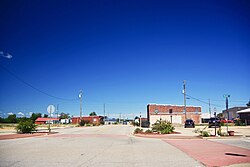 Main Street | |
 Location of Hackleburg in Marion County, Alabama. | |
| Coordinates: 34°16′17″N 87°49′50″W / 34.27139°N 87.83056°W | |
| Country | United States |
| State | Alabama |
| County | Marion |
| Area | |
| • Total | 15.29 sq mi (39.59 km2) |
| • Land | 15.28 sq mi (39.56 km2) |
| • Water | 0.01 sq mi (0.03 km2) |
| Elevation | 938 ft (286 m) |
| Population (2010) | |
| • Total | 1,516 |
| • Estimate (2019)[2] | 1,258 |
| • Density | 82.36/sq mi (31.80/km2) |
| Time zone | UTC-6 (Central (CST)) |
| • Summer (DST) | UTC-5 (CDT) |
| ZIP code | 35564 |
| Area code(s) | 205, 659 |
| FIPS code | 01-32560 |
| GNIS feature ID | 0119530 |
| Website | townofhackleburg |

Hackleburg is a town in Marion County, Alabama, United States. It incorporated on August 23, 1909.[3] At the 2010 census, its population was 1,430.
History[]
Hackleburg developed in the early 19th century as a stop along Jackson's Military Road. It was named for the abundance of hackberry trees in the area. A post office opened in the town in 1885.[3]
Hackleburg incorporated in 1909 following the construction of a branch line of the Illinois Central Railroad through the area.[3]
2011 tornado[]
On April 27, 2011 Hackleburg suffered catastrophic damage when it was hit by an EF5 tornado – part of the 2011 Super Outbreak. Eighteen Hackleburg residents died in the storm.[4][5] On May 2, the Red Cross declared the city 75 percent destroyed.[6] Many people rebuilt here, although 2017 population estimates showed a slight decline from 2010.
Geography[]
Hackleburg is located at 34°16′17″N 87°49′51″W / 34.27139°N 87.83083°W.[7] The town is located in northern Marion County, and U.S. Route 43 and Alabama State Route 172 were constructed to intersect here. US 43 connects the town with Russellville to the north and Hamilton to the south.
Dismals Canyon, a National Natural Landmark, is located just north of Hackleburg. According to the U.S. Census Bureau, the town has a total area of 15.3 square miles (40 km2), all land.
Demographics[]
| Historical population | |||
|---|---|---|---|
| Census | Pop. | %± | |
| 1910 | 286 | — | |
| 1920 | 376 | 31.5% | |
| 1930 | 628 | 67.0% | |
| 1940 | 492 | −21.7% | |
| 1950 | 534 | 8.5% | |
| 1960 | 527 | −1.3% | |
| 1970 | 726 | 37.8% | |
| 1980 | 883 | 21.6% | |
| 1990 | 1,161 | 31.5% | |
| 2000 | 1,527 | 31.5% | |
| 2010 | 1,516 | −0.7% | |
| 2019 (est.) | 1,258 | [2] | −17.0% |
| U.S. Decennial Census[8] 2013 Estimate[9] | |||
At the 2000 census there were 1,527 people, 657 households, and 444 families in the town. The population density was 99.7 people per square mile (38.5/km2). There were 737 housing units at an average density of 48.1 per square mile (18.6/km2). The racial makeup of the town was 99.21% White, 0.13% Black or African American, 0.07% Native American, 0.07% from other races, and 0.52% from two or more races. 0.26% of the population were Hispanic or Latino of any race.[10] Of the 657 households 28.9% had children under the age of 18 living with them, 54.3% were married couples living together, 9.6% had a female householder with no husband present, and 32.4% were non-families. 29.5% of households were one person and 16.6% were one person aged 65 or older. The average household size was 2.32 and the average family size was 2.88.
The age distribution was 23.2% under the age of 18, 7.3% from 18 to 24, 27.1% from 25 to 44, 25.7% from 45 to 64, and 16.6% 65 or older. The median age was 40 years. For every 100 females, there were 90.4 males. For every 100 females age 18 and over, there were 89.3 males.
The median household income was $26,075 and the median family income was $30,938. Males had a median income of $26,542 versus $20,739 for females. The per capita income for the town was $17,239. About 10.8% of families and 14.8% of the population were below the poverty line, including 13.2% of those under age 18 and 25.8% of those age 65 or over.
2010 census[]
At the 2010 census there were 1,516 people, 656 households, and 433 families in the town. The population density was 99.8 people per square mile (38.5/km2). There were 769 housing units at an average density of 50.3 per square mile (19.4/km2). The racial makeup of the town was 97.7% White, 0.1% Black or African American, 0.2% Native American, 1.0% from other races, and 1.1% from two or more races. 1.3% of the population were Hispanic or Latino of any race.[11] Of the 656 households 26.1% had children under the age of 18 living with them, 50.3% were married couples living together, 11.9% had a female householder with no husband present, and 34.0% were non-families. 30.5% of households were one person and 17.7% were one person aged 65 or older. The average household size was 2.31 and the average family size was 2.83.
The age distribution was 20.5% under the age of 18, 8.8% from 18 to 24, 21.1% from 25 to 44, 28.4% from 45 to 64, and 21.1% 65 or older. The median age was 44.7 years. For every 100 females, there were 89.3 males. For every 100 females age 18 and over, there were 89.5 males.
The median household income was $29,350 and the median family income was $34,375. Males had a median income of $27,426 versus $24,625 for females. The per capita income for the town was $16,584. About 27.4% of families and 31.1% of the population were below the poverty line, including 51.3% of those under age 18 and 18.5% of those age 65 or over.
Education[]
Hackleburg is a part of the Marion County Schools district.
Hackleburg Elementary and High School's mascot is the Panther, and the school colors are Black and Gold. The schools were among the many buildings destroyed by the tornado of April 27, 2011.
The Marion County Board of Education initiated construction of a $25 million total K-12 academic complex in Hackleburg. It opened for the 2015–2016 school year.
Athletics[]
The 2003 and the 2004 Hackleburg High School baseball teams finished as runners-up in the Alabama High School Athletic Association state baseball tournament. The 2007 Hackleburg High School baseball team won the 1A State Championship in the Alabama High School Athletic Association state baseball tournament. It marked the first state championship in the school's history.[12] In December 2009 the High School football team became 1A State runners-up in the AHSAA football championship losing to the Brantley Bulldogs.[13]
Notable people[]
- Sonny James, Country Music Hall of Fame singer
- Charles Moore, civil rights photojournalist
- Gary Palmer, congressman
References[]
- ^ "2019 U.S. Gazetteer Files". United States Census Bureau. Retrieved June 29, 2020.
- ^ Jump up to: a b "Population and Housing Unit Estimates". United States Census Bureau. May 24, 2020. Retrieved May 27, 2020.
- ^ Jump up to: a b c Christopher Maloney, "Hackleburg," Encyclopedia of Alabama, 16 July 2018.
- ^ "Alabama storm death toll at 238". Montgomery Advertiser. www.montgomeryadvertiser.com. May 12, 2011. Retrieved May 13, 2011.
- ^ Sentell, Jeff (May 12, 2011). "Hackleburg baseball team loses in quarterfinals, but tornado ravaged town's spirit still soars". al.com. www.al.com. Retrieved May 13, 2011.
- ^ Ott, Tanya (May 3, 2011). "In Small Towns Hit By Twisters, 'You Feel Ignored'". NPR. Retrieved 3 May 2011.
- ^ "US Gazetteer files: 2010, 2000, and 1990". United States Census Bureau. 2011-02-12. Retrieved 2011-04-23.
- ^ "U.S. Decennial Census". Census.gov. Retrieved June 6, 2013.
- ^ "Annual Estimates of the Resident Population: April 1, 2010 to July 1, 2013". Archived from the original on May 22, 2014. Retrieved June 3, 2014.
- ^ "U.S. Census website". United States Census Bureau. Retrieved 2008-01-31.
- ^ "U.S. Census website". United States Census Bureau. Retrieved 2015-08-03.
- ^ "Perfect Ending". The Times Daily. 2007-06-16. Retrieved 2010-04-12.
- ^ "Brantley snuffs Hackleburg's title hopes". al.com. 2009-12-04. Retrieved 2010-04-12.
External links[]
 Media related to Hackleburg, Alabama at Wikimedia Commons
Coordinates: 34°16′17″N 87°49′51″W / 34.27146°N 87.830826°W
| hide Municipalities and communities of Marion County, Alabama, United States | ||
|---|---|---|
| Cities |  | |
| Towns | ||
| Unincorporated communities | ||
| Ghost town | ||
| Footnotes | ‡This populated place also has portions in an adjacent county or counties | |
| ||
| Authority control |
|
|---|
- Towns in Marion County, Alabama
- Towns in Alabama