Hampden, Newfoundland and Labrador
Hampden | |
|---|---|
Town | |
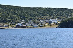 Hampden from the White Bay | |
 Hampden Location of Hampden in Newfoundland | |
| Coordinates: 49°31′59″N 56°52′01″W / 49.533°N 56.867°W | |
| Country | |
| Province | |
| The Town of Hampden | December 1959 |
| Government | |
| • Mayor | Calvin Wilton |
| • Member of the Newfoundland & Labrador House of Assembly | Andrew Furey (LIB) |
| • Members of the Canadian House of Commons | Gudie Hutchings (LIB) |
| Area | |
| • Total | 32.9 km2 (12.7 sq mi) |
| Elevation | 100 m (300 ft) |
| Population (2016) | |
| • Total | 429 |
| Time zone | UTC-3:30 (Newfoundland Time) |
| • Summer (DST) | UTC-2:30 (Newfoundland Daylight) |
| Postal Code | A0K 2Y0 |
| Area code(s) | 709 |
| Highways | |


Hampden is a town in the Canadian province of Newfoundland and Labrador. The town has a population of 429. Two islands can be seen from the shore of Hampden, Granby Island and Millers Island. The latter is much closer to the town and is the host of a tuberculosis grave-site.[1]
History[]
Hampden was named after English politician John Hampden.
Many communities were resettled into Hampden after the island was brought into Canadian Confederation on 31 March 1949, where the Joey Smallwood government pushed a resettlement plan that involved over 300 villages and 28,000 people.[2]
Demographics[]
Population 2016: 429[3]
Population 2011: 457[3]
Population, 2006: 489[4]
Population, 2001: 544[5]
Population, 1996: 651[5]
1996 to 2016 population change: -34.1 percent
Number of dwellings: 175[6]
Land (square kilometers): 32.97[6]
See also[]
- List of cities and towns in Newfoundland and Labrador
References[]
- ^ https://www.geocaching.com/geocache/GC6PMMW_sojourn-8-millers-island-graveyard?guid=276ac8e3-6010-4f5a-85ae-382dbfd05431
- ^ https://www.mun.ca/mha/resettlement/rs_intro.php
- ^ a b http://www12.statcan.gc.ca/census-recensement/2016/dp-pd/prof/details/Page.cfm?Lang=E&Geo1=CSD&Code1=1005008&Geo2=PR&Code2=35&Data=Count&SearchText=Bayside&SearchType=Begins&SearchPR=01&B1=All
- ^ https://roadsidethoughts.com/nl/hampden-profile.htm
- ^ a b http://www12.statcan.ca/English/Profil01/CP01/Details/Page.cfm?Lang=E&Geo1=CSD&Code1=1005008&Geo2=PR&Code2=10&Data=Count&SearchText=Hampden&SearchType=Begins&SearchPR=01&B1=All&GeoLevel=&GeoCode=1005008
- ^ a b http://www12.statcan.gc.ca/census-recensement/2016/as-sa/fogs-spg/Facts-csd-eng.cfm?GC=1005008&GK=CSD&LANG=Eng&TOPIC=1
Division No. 5, Newfoundland and Labrador (Humber District) | ||
|---|---|---|
| Cities |  | |
| Towns | ||
| Unorganized subdivisions |
| |
| Designated places | ||
| Subdivisions and statistical units |
|
|---|---|
| Communities |
|
| Cities | |
| Towns |
|
| Inuit community governments | |
| |
This Newfoundland and Labrador location article is a stub. You can help Wikipedia by . |
- Towns in Newfoundland and Labrador
- Newfoundland and Labrador geography stubs