Baine Harbour
This article needs additional citations for verification. (January 2021) |
Baine Harbour | |
|---|---|
Town | |
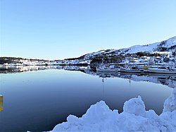 | |
 Baine Harbour Location of Baine Harbour in Newfoundland | |
| Coordinates: 47°22′00″N 54°55′00″W / 47.36667°N 54.91667°W | |
| Country | |
| Province | |
| Incorporated | 1970 |
| Government | |
| • Mayor | Harold Kenway |
| Area | |
| • Land | 4.82 km2 (1.86 sq mi) |
| Population (2016)[1] | |
| • Total | 124 |
| • Density | 25.7/km2 (67/sq mi) |
| Time zone | UTC-3:30 (Newfoundland Time) |
| • Summer (DST) | UTC-2:30 (Newfoundland Daylight) |
| Area code(s) | 709 |
| Highways | |

Baine Harbour (2016 population: 124[1]) is a Canadian community in the province of Newfoundland and Labrador.
Incorporated as a "Government Community" in 1970, it is located northeast of Marystown.
In 1911 it had one store, one church and one hotel. The Way office was established in 1883. The first Waymaster was Lemuel Roberts. The first postmaster was W. Rodway in 1949.
It had a population of 204 in 1976, and 124 in 2016.
See also[]
- List of cities and towns in Newfoundland and Labrador
Coordinates: 47°22′N 54°55′W / 47.367°N 54.917°W
References[]
- ^ a b c "Census Profile, 2016 Census: Baine Harbour, Town [Census subdivision], Newfoundland and Labrador". Statistics Canada. Retrieved October 21, 2019.
| Subdivisions and statistical units |
|
|---|---|
| Communities |
|
| Cities | |
| Towns |
|
| Inuit community governments | |
| |
This Newfoundland and Labrador location article is a stub. You can help Wikipedia by . |
Categories:
- Populated coastal places in Canada
- Towns in Newfoundland and Labrador
- Newfoundland and Labrador geography stubs