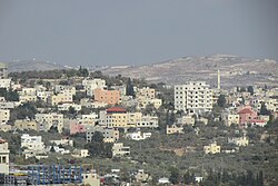
Haris, Salfit
Haris | |
|---|---|
Municipality type D (Village council) | |
| Arabic transcription(s) | |
| • Arabic | حارس |
 Haris | |
 Haris Location of Haris within Palestine | |
| Coordinates: 32°06′51″N 35°08′28″E / 32.11417°N 35.14111°ECoordinates: 32°06′51″N 35°08′28″E / 32.11417°N 35.14111°E | |
| Palestine grid | 163/169 |
| State | State of Palestine |
| Governorate | Salfit |
| Government | |
| • Type | Village council |
| Elevation | 486 m (1,594 ft) |
| Population (2006) | |
| • Total | 3,063 |
| Name meaning | The watch[2] |

Haris (Arabic: حارس) is a Palestinian town located in the Salfit Governorate in the northern West Bank, 24 kilometers Southwest of Nablus. According to the Palestinian Central Bureau of Statistics, it had a population of 3,427 approximately in mid-year 2007.[3]
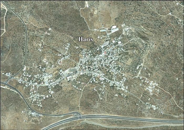
Location[]
Haris is located 5.11 kilometers (3.18 mi) north-west of Salfit. It is bordered by Kifl Haris to the east, Salfit and Bruqin to the south, Sarta and Qarawat Bani Hassan to the west, and Deir Istiya to the north.[1]
History[]
Sherds from the Mamluk era have been found here.[4] In 1359 it is mentioned by as a place bought by the Sultan.[4]
Ottoman era[]
In 1517, the village was included in the Ottoman empire with the rest of Palestine, and potsherds from the early Ottoman period have been found.[4] It appeared in the 1596 tax-records as Harit, located in the Nahiya of Jabal Qubal, part of the Sanjak of Nablus. The population was 21 households, all Muslim. They paid a fixed tax sum of 12,000 akçe, in addition to taxes on "agnan", bee hives, and occasional revenues; a total of 13,300 akçe.[5]
In 1838, Edward Robinson noted it as a village, Harith, in the Jurat Merda district, south of Nablus.[6]
In 1870 Guérin observed here a building used as a mosque, divided into three naves separated by marble columns of different sizes, and evidently ancient. 'On a neighbouring Tell, which commands the village, are the ruins of an ancient tower. The spot is now planted with olives. Two ancient tombs and several cisterns cut in the rock once belonged to the ancient city which stood here.'[7]
In 1882, the PEF's Survey of Western Palestine (SWP) described Haris as "a medium sized village on high ground built of stone, and supplied by cisterns. It has rock-cut tombs and is probably an ancient site; there are fine olive groves round it." [8]
British Mandate era[]
In the 1922 census of Palestine conducted by the British Mandate authorities, Haris (called: Hares) had a population of 285, all Muslims,[9] increasing in the 1931 census to 394, except for one Christian all were Muslim, in a total of 99 houses.[10]
In the 1945 statistics the population was 540, all Muslims,[11] while the total land area was 8,391 dunams, according to an official land and population survey.[12] Of this, 1,545 were used for plantations and irrigable land, 1,341 for cereals,[13] while 21 dunams were classified as built-up areas.[14]
Jordanian era[]
In the wake of the 1948 Arab–Israeli War, and after the 1949 Armistice Agreements, Haris came under Jordanian rule.
In 1961, the population was 726.[15]
Post-1967[]
Since the Six-Day War in 1967, Haris has been held under Israeli occupation.
After the 1995 accords, about 6% of village land was classified as Area B land, while the remaining 94% was classified as Area C.[16]
Loss of land[]
Haris has been directly affected by the construction of the wall on the West Bank and the settlements surrounding Ariel and the Barkan Industrial Park. ARIJ, a Palestinian research institute lists the losses as follows:
| Settlement | Date of establishment | Pop 2007 | Area/Dunums | Area expropriated from the village pre 2008 |
|---|---|---|---|---|
| Barqan | 1981 | 1,300 | 649 | 304 |
| Revava | 1991 | 827 | 399 | 78 |
| Barqan Industrial Zone | 1981 | -- | 1,417 | 1,417 |
| Qiryat Netafim | 1982 | 438 | 386 | 188 |
| Ariel West Park Industrial | NA | -- | 1,728 | 1,110 |
| Total | 2,565 | 4,579 | 3,097 | |
| Source: ARIJ 2008[17] | ||||
In late October 2014, Israel expropriated a further 20 dunams (5 acres) of land, near the Israeli settlement of Barkan.[18]
On May 24, 2020, Israeli settlers from the Revava settlement, located on the lands of Haris, northwest of Salfit Governorate, uprooted and stolen more than 150–200 olive trees.[19][20] The began performing Peaceful Sit-in every Friday in the lands of Haris since May 29, 2020.
References[]
- ^ Jump up to: a b Haris Village Profile, ARIJ, p. 4
- ^ Palmer, 1881, p. 229
- ^ Projected Mid -Year Population for Salfit District by Locality 2004- 2006 Archived 2008-04-24 at the Wayback Machine Palestinian Central Bureau of Statistics
- ^ Jump up to: a b c Finkelstein et al, 1997, p. 454
- ^ Hütteroth and Abdulfattah, 1977, p. 131
- ^ Robinson and Smith, 1841, vol 3, Appendix 2, p. 127
- ^ Guérin, 1875, p. 159–160; as given by Conder and Kitchener, 1882, SWP II, p. 322
- ^ Conder and Kitchener, 1882, SWP II, p. 284
- ^ Barron, 1923, Table IX, p. 25
- ^ Mills, 1932, p. 61
- ^ Government of Palestine, Department of Statistics, 1945, p. 18
- ^ Government of Palestine, Department of Statistics. Village Statistics, April, 1945. Quoted in Hadawi, 1970, p. 59
- ^ Government of Palestine, Department of Statistics. Village Statistics, April, 1945. Quoted in Hadawi, 1970, p. 106
- ^ Government of Palestine, Department of Statistics. Village Statistics, April, 1945. Quoted in Hadawi, 1970, p. 156
- ^ Government of Jordan, Department of Statistics, 1964, p. 26
- ^ Haris Village Profile, ARIJ, 2013, p. 17
- ^ ARIJ, New Palestinian houses threatened of Demolition by the Israeli Occupation Authorities, 2 December 2008
- ^ 'Israel confiscates 20 dunums of Palestinian land near Salfit', Ma'an News Agency 23 October 2014
- ^ "Settlers of "Revava" cut down 150 olive saplings in Haris Vallage / Salfit governorate – POICA". Retrieved 2020-06-26.
- ^ Protection of Civilians Report | 12 May - 1 June 2020
Bibliography[]
- Barron, J.B., ed. (1923). Palestine: Report and General Abstracts of the Census of 1922. Government of Palestine.
- Conder, C.R.; Kitchener, H.H. (1882). The Survey of Western Palestine: Memoirs of the Topography, Orography, Hydrography, and Archaeology. 2. London: Committee of the Palestine Exploration Fund.
- Finkelstein, I.; Lederman, Zvi, eds. (1997). Highlands of many cultures. Tel Aviv: Institute of Archaeology of Tel Aviv University Publications Section. ISBN 965-440-007-3.
- Government of Jordan, Department of Statistics (1964). First Census of Population and Housing. Volume I: Final Tables; General Characteristics of the Population (PDF).
- Government of Palestine, Department of Statistics (1945). Village Statistics, April, 1945.
- Guérin, V. (1875). Description Géographique Historique et Archéologique de la Palestine (in French). 2: Samarie, pt. 2. Paris: L'Imprimerie Nationale.
- Hadawi, S. (1970). Village Statistics of 1945: A Classification of Land and Area ownership in Palestine. Palestine Liberation Organization Research Center.
- Hütteroth, Wolf-Dieter; Abdulfattah, Kamal (1977). Historical Geography of Palestine, Transjordan and Southern Syria in the Late 16th Century. Erlanger Geographische Arbeiten, Sonderband 5. Erlangen, Germany: Vorstand der Fränkischen Geographischen Gesellschaft. ISBN 3-920405-41-2.
- Mills, E., ed. (1932). Census of Palestine 1931. Population of Villages, Towns and Administrative Areas. Jerusalem: Government of Palestine.
- Palmer, E.H. (1881). The Survey of Western Palestine: Arabic and English Name Lists Collected During the Survey by Lieutenants Conder and Kitchener, R. E. Transliterated and Explained by E.H. Palmer. Committee of the Palestine Exploration Fund.
- Robinson, E.; Smith, E. (1841). Biblical Researches in Palestine, Mount Sinai and Arabia Petraea: A Journal of Travels in the year 1838. 3. Boston: Crocker & Brewster.
External links[]
- Welcome To Haris
- Survey of Western Palestine, Map 14: IAA, Wikimedia commons
- Haris Village (Fact Sheet), Applied Research Institute–Jerusalem, ARIJ
- Haris Village Profile, ARIJ
- Haris, aerial photo, ARIJ
- Development Priorities and Needs in Haris, ARIJ
| hide | ||
|---|---|---|
| Municipalities |
| |
| Villages | ||
- Salfit Governorate
- Towns in Salfit Governorate
- Municipalities of the State of Palestine