Hatley, Quebec (municipality)
Hatley | |
|---|---|
Municipality | |
 Hatley United Church on Main St. | |
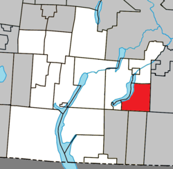 Location within Memphrémagog RCM | |
 Hatley Location in southern Quebec | |
| Coordinates: 45°11′N 71°56′W / 45.18°N 71.93°WCoordinates: 45°11′N 71°56′W / 45.18°N 71.93°W[1] | |
| Country | |
| Province | |
| Region | Estrie |
| RCM | Memphrémagog |
| Constituted | September 27, 1995 |
| Government | |
| • Mayor | Denis Ferland |
| • Federal riding | Compton—Stanstead |
| • Prov. riding | Orford |
| Area | |
| • Total | 66.60 km2 (25.71 sq mi) |
| • Land | 60.70 km2 (23.44 sq mi) |
| Population (2016)[4] | |
| • Total | 696 |
| • Density | 12.5/km2 (32/sq mi) |
| • Pop 2011-2016 | |
| • Dwellings | 469 |
| Time zone | UTC−5 (EST) |
| • Summer (DST) | UTC−4 (EDT) |
| Postal code(s) | J0B 4B0 |
| Area code(s) | 819 |
| Highways | |
| Website | www |

Hatley is a municipality of about 696 people, in Memphrémagog Regional County Municipality in the Estrie region of Quebec, Canada. It lies to the south of the township municipality of the same name.
An otherwise quiet and tiny agricultural setting, one of Hatley's main claims to fame is its annual Canada Day Celebration which always takes place on July 1. Along with a parade (featuring horses, floats, antique cars, tractors, children on decorated bikes and any number of other entrants), the day includes games for children, artisan vendors, a book sale, community lunch, local performers, and ends off with a fireworks display.
Demographics[]
Population[]
Population trend:[5]
| Census | Population | Change (%) |
|---|---|---|
| 2016 | 696 | |
| 2011 | 761 | |
| 2006 | 777 | |
| 2001 | 709 | |
| 1996 | 642 | |
| 1991 | 675 | N/A |
Language[]
Mother tongue (2016)[6]
| Language | Population | Pct (%) |
|---|---|---|
| French only | 455 | 65.37% |
| English only | 230 | 33.05% |
| Other non-official languages | 11 | 1.58% |
See also[]
References[]
- ^ Reference number 308938 of the Commission de toponymie du Québec (in French)
- ^ Jump up to: a b Ministère des Affaires municipales, des Régions et de l'Occupation du territoire: Hatley (municipality)
- ^ Parliament of Canada Federal Riding History: COMPTON--STANSTEAD (Quebec)
- ^ Jump up to: a b 2011 Statistics Canada Census Profile: Hatley (municipality), Quebec
- ^ Statistics Canada: 1996, 2001, 2006, 2011 census
- ^ 2011 Statistics Canada Community Profile: Hatley, Quebec (municipality)
External links[]
 Media related to Hatley, Quebec (municipality) at Wikimedia Commons
| show Places adjacent to Hatley, Quebec (municipality) |
|---|
| hide | |
|---|---|
| Cities & Towns | |
| Municipalities | |
| Townships | |
| Villages | |
| |
| Authority control |
|
|---|
Categories:
- Municipalities in Quebec
- Incorporated places in Estrie