Orford, Quebec
Orford | |
|---|---|
Township municipality | |
 | |
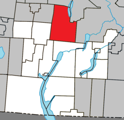 Location within Memphrémagog RCM | |
 Orford Location in southern Quebec | |
| Coordinates: 45°23′N 72°12′W / 45.38°N 72.2°WCoordinates: 45°23′N 72°12′W / 45.38°N 72.2°W[1] | |
| Country | |
| Province | |
| Region | Estrie |
| RCM | Memphrémagog |
| Constituted | July 1, 1855 |
| Named for | Orford, Suffolk[1] |
| Government | |
| • Mayor | Pierre Bastien |
| • Federal riding | Brome—Missisquoi |
| • Prov. riding | Orford |
| Area | |
| • Total | 148.60 km2 (57.37 sq mi) |
| • Land | 136.27 km2 (52.61 sq mi) |
| Population (2011)[4] | |
| • Total | 3,575 |
| • Density | 26.2/km2 (68/sq mi) |
| • Pop 2006-2011 | |
| • Dwellings | 2,470 |
| Time zone | UTC−5 (EST) |
| • Summer (DST) | UTC−4 (EDT) |
| Postal code(s) | J1X 8R8 |
| Area code(s) | 819 |
| Highways | |
| Website | www |

Orford is a township municipality of about 3,600 people in Memphrémagog Regional County Municipality in the Estrie region of Quebec, Canada.
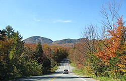
Orford's main attraction is its ski resort on Mount Orford, attracting thousands of people every winter.
Orford is well known for the Mont-Orford National Park. The park has thousands of acres of forest and two major lakes, Stukley and Fraser. Cherry river runs through the park and ends up in Lake Memphremagog. The township has many lakes and is a tourist destination in Quebec.
Demographics[]
Population[]
Population trend:[5]
| Census | Population | Change (%) |
|---|---|---|
| 2011 | 3,575 | |
| 2006 | 2,979 | |
| ADJ | 2,383 (+) | |
| 2001 | 1,987 | |
| 1996 | 1,427 | |
| 1991 | 985 | N/A |
ADJ = adjusted figure due to boundary change.
Language[]
Mother tongue (2011)[6]
| Language | Population | Pct (%) |
|---|---|---|
| French only | 3,310 | 92.85% |
| English only | 185 | 5.19% |
| Both English and French | 30 | 0.84% |
| Other languages | 40 | 1.12% |
See also[]
References[]
- ^ a b Reference number 45673 of the Commission de toponymie du Québec (in French)
- ^ a b Ministère des Affaires municipales, des Régions et de l'Occupation du territoire: Orford
- ^ Parliament of Canada Federal Riding History: BROME--MISSISQUOI (Quebec)
- ^ a b 2011 Statistics Canada Census Profile: Orford, Quebec
- ^ Statistics Canada: 1996, 2001, 2006, 2011 census
- ^ 2011 Statistics Canada Community Profile: Orford, Quebec
External links[]
 Media related to Orford, Quebec at Wikimedia Commons
Adjacent Municipal Subdivisions | ||||||||||||||||
|---|---|---|---|---|---|---|---|---|---|---|---|---|---|---|---|---|
| ||||||||||||||||
| Cities & Towns | |
|---|---|
| Municipalities | |
| Townships | |
| Villages | |
| |
Categories:
- Township municipalities in Quebec
- Incorporated places in Estrie