Quebec Route 220
 | ||||
|---|---|---|---|---|
 | ||||
| Route information | ||||
| Maintained by Transports Québec | ||||
| Length | 36.9 km[1] (22.9 mi) | |||
| Major junctions | ||||
| West end | ||||
| East end | ||||
| Highway system | ||||
| ||||
Route 220 is a provincial highway located in the Estrie region of Quebec. The highway runs from Sainte-Anne-de-la-Rochelle at the junction of Route 243 and ends west of downtown Sherbrooke at Autoroute 410. The road connects the northern section of the .
Municipalities along Route 220[]

Saint-Élie Road in Sherbrooke.

Route 220 at Orford.
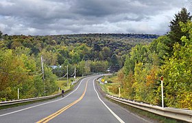
Route 220 near Lake Brompton.


See also[]
References[]
- ^ Ministère des transports, "Distances routières", page 83, Les Publications du Québec, 2005
External links[]
- Official Transports Quebec Road Network Map (in French)
- Route 220 on Google Maps
This Quebec road, road transport or highway-related article is a stub. You can help Wikipedia by . |
Categories:
- Quebec Routes
- Transport in Sherbrooke
- Quebec road stubs