Quebec Route 223
 | ||||
|---|---|---|---|---|
 | ||||
| Route information | ||||
| Maintained by Transports Québec | ||||
| Length | 128.6 km[1] (79.9 mi) | |||
| Major junctions | ||||
| South end | ||||
| North end | ||||
| Highway system | ||||
| ||||
Route 223 is a 128.6 km north/south highway on the south shore of the Richelieu River in Quebec. Its northern terminus is in Sorel-Tracy at the junction of Route 132 and its southern terminus is close to Lacolle, where it crosses the U.S. border at the Rouses Point–Lacolle 223 Border Crossing and continues into New York state as U.S. Route 11.
Municipalities along Route 223[]
- Notre-Dame-du-Mont-Carmel
- Saint-Paul-de-l'Île-aux-Noix
- Saint-Jean-sur-Richelieu
- Chambly
- Carignan
- McMasterville
- Beloeil
- Saint-Marc-sur-Richelieu
- Saint-Antoine-sur-Richelieu
- Saint-Roch-de-Richelieu
- Sorel-Tracy
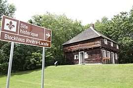
Blockhaus Rivière-Lacolle historic site sign on route 223.
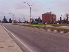
Route 223 through Saint-Jean-sur-Richelieu is made of 4 lanes, divided by a median.


See also[]
References[]
- ^ Ministère des transports, "Distances routières", page 84, Les Publications du Québec, 2005
External links[]
| Wikimedia Commons has media related to Quebec Route 223. |
This Quebec road, road transport or highway-related article is a stub. You can help Wikipedia by . |
Categories:
- Quebec Routes
- Transport in Saint-Jean-sur-Richelieu
- Transport in Sorel-Tracy
- Quebec road stubs