Quebec Autoroute 30
 | ||||
|---|---|---|---|---|
| Autoroute de l'Acier | ||||
 | ||||
| Route information | ||||
| Maintained by Transports Québec | ||||
| Length | 161.3 km[1][2] (100.2 mi) | |||
| Existed | 1968[2]–present | |||
| Major junctions | ||||
| West end | ||||
| East end | ||||
| Location | ||||
| Major cities | Vaudreuil-Dorion, Salaberry-de-Valleyfield, Châteauguay, Candiac, La Prairie, Boucherville, Brossard, Longueuil, Saint-Bruno-de-Montarville, Sainte-Julie, Sorel-Tracy, Varennes, Bécancour | |||
| Highway system | ||||
| ||||
Autoroute 30 (A-30), or the Autoroute de l'Acier (In English, Steel Freeway) is an Autoroute in Quebec, Canada. Construction of the A-30 dates back to the early days of autoroute construction in the 1960s. Originally called Highway 3,[3] the A-30 was designed to replace Route 132 as the main artery linking the communities along the South Shore of the St. Lawrence River. The A-30 was originally intended to begin at the U.S. border at Dundee and end at Saint-Pierre-les-Becquets (in Centre-du-Québec).[4] In the late 1970s an eight-year moratorium on new autoroute construction in favour of public transport by the Parti Québécois prevented implementation of that plan.
The original section of Autoroute 30 in 1968 linked Sorel-Tracy to Route 116, which was then called Highway 9. The A-30 was extended to an interchange with Autoroute 10 in Brossard by 1985 and to Autoroute 15 in Candiac by 1996.
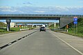
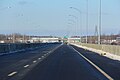
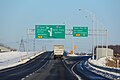
Growing road congestion in and around Montreal led to the announcement in 2006 of a federal-provincial partnership to complete A-30 as southwestern bypass ring road.[5] At that time, the section from Châteauguay to Vaudreuil-Dorion was to be tolled, however by 2009 it was decided to collect tolls only on the St. Lawrence bridge. A-30 was extended north of the St. Lawrence River (over a new crossing) to a realigned interchange with Autoroute 20 and Autoroute 540 in Vaudreuil-Dorion, afterward A-540 was annexed and renamed as an extension of A-30. As construction progressed, short sections of the original A-30 that are bypassed by the new route were converted to spur routes and assigned new route numbers; for instance the old alignment of A-30 south of Salaberry-de-Valleyfield was renamed Autoroute 530. Opened to traffic on December 15, 2012, the realigned Autoroute 30 permits motorists travelling the Quebec City–Windsor Corridor to bypass Montreal.[6][7][8]
Description[]
There are two discontinuous sections of A-30:
Montérégie[]
The main 143 km (89 mi) segment extends from Autoroute 40 in Vaudreuil-Dorion to Route 133 in Sorel-Tracy.
From the junction of Autoroute 20 in Vaudreuil-Dorion to Route 138 in Châteauguay a completely new freeway was constructed between 2007 and 2012, opening to traffic in December 2012. This new section, built under a Public-Private Partnership, along with the former A-540 west of Vaudreuil make up the first 38 km (24 mi) of the highway now. An approximately 21-kilometre (13 mi) long section bypasses the Mohawk territory of Kahnawake and the South Shore communities of Saint-Constant, Delson, and Candiac. The Kahnawake bypass was built following the 1990 Oka Crisis and extended to the other three communities between 2005 and 2011.[4] The A-30 was originally intended to supplant Route 132, crossing Kahnawake to a junction with the Honoré Mercier Bridge. Local opposition to the proposed route from the late 1960s coupled with the disruption of the Oka Crisis in 1990 prompted the decision to change the course of the new autoroute to bypass the Mohawk territory[9] This new alignment resulted in the 1990 construction, 1992 twinning, then the 2010 redesignation of a 3.2 km (2.0 mi) portion of highway as Autoroute 730. The A-730 now extends from the A-30 mainline in Saint-Constant to Route 132 in Sainte-Catherine. Another 3.2 km (2.0 mi) section from the existing A-30 to Route 132 in Candiac has been redesignated Autoroute 930 since construction of the Jean-Leman section ended in November 2011. Further west, an 8.3 km (5.2 mi) bypass of Salaberry-de-Valleyfield became Autoroute 530 in 2012 when construction of the A-30 extension was completed.
Northeast of Montreal the autoroute parallels Route 132, bypassing the steelmaking centres of Contrecoeur and Sorel-Tracy.
Centre-du-Québec[]
An 18.3 km super two segment in Bécancour, from Route 132 immediately west to an interchange with Autoroute 55 (near Laviolette Bridge, south of Trois-Rivières). The A-30 parallels the St. Lawrence River, bypassing the communities of Sainte-Angèle-de-Laval and Des Ormeaux and linking the Port of Bécancour to the autoroute network. Multiplexed with Route 132, the A-30 continues as a two-lane road for a short distance further before ending at the western approach to Gentilly. The road continues on as Route 132.
Exit list[]
This section contains a table that is missing kilometre posts for one or more junctions. |
| RCM | Location | km | mi | Old exit | New exit | Destinations | Notes |
|---|---|---|---|---|---|---|---|
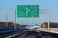
| Montérégie | Vaudreuil-Dorion | 0.0 | 0.0 | 4 | 1 | A-40 exit 32; access to Mirabel Airport | |
| 1.6 | 0.99 | 3 | 2 | ||||
| 3.4 | 2.1 | 2 | 4 | ||||
| 4.9 | 3.0 | 1 | 5 | A-20 exit 29; access to P.E. Trudeau Airport | |||
| Les Cèdres | 8.6 | 5.3 | 9 | ||||
| Soulanges Canal | Tunnel | ||||||
| Soulanges Canal Saint Lawrence River | Toll barrier | ||||||
| Saint Lawrence River | Serge Marcil Bridge | ||||||
| Salaberry-de-Valleyfield | 13.0 | 8.1 | 13 | A-530 exit 12 | |||
| Beauharnois | 16.5 | 10.3 | 17 | Chemin du Canal | |||
| Beauharnois Canal | Madeleine Parent Bridge | ||||||
| Beauharnois | 22.0 | 13.7 | 22 | ||||
| 25.8 | 16.0 | 26 | |||||
| Châteauguay | 34.8 | 21.6 | 35 | Chemin de la Haute-Rivière / Boulevard René-Lévesque | |||
| 37.2 | 23.1 | 80 | 38 | ||||
| 40.6 | 25.2 | 83 | 41 | Industriel boulevard / Sainte-Marguerite boulevard | |||
| Saint-Isidore | 43.9 | 27.3 | 86 | 44 | |||
| Saint-Constant | 46.4 | 28.8 | 89[10] | 47[11] | A-730 exit 1 | ||
| Candiac | 54.2 | 33.7 | 55 | Eastbound exit and westbound entrance; A-15 exit 40 | |||
| 58.1 | 36.1 | 58 | Westbound exit and eastbound entrance; A-15 exit 42 | ||||
| La Prairie | 62.3 | 38.7 | 104 | 62 | |||
| Brossard | 64.4 | 40.0 | 107 | 65 | Boulevard Matte, Boulevard de Rome | ||
| 67.3 | 41.8 | 109 | 67 | A-10 exit 11 | |||
| Brossard–Saint-Hubert city line | 69.2 | 43.0 | 110 | 69 | Grande-Allée | ||
| Saint-Hubert | 73.2 | 45.5 | 115 | 73 | |||
| Saint-Bruno-de-Montarville | 76.0 | 47.2 | 118 | 76 | Route 116 exit 9 | ||
| 77.8 | 48.3 | 120 | 78 | Access to Saint-Hubert Airport | |||
| 79.8 | 49.6 | 121 | 80 | Montée Montarville | |||
| Boucherville | 83.5 | 51.9 | 125 | 83 | A-20 exit 98 | ||
| Boucherville–Sainte-Julie city line | 87.0 | 54.1 | 128 | 87 | Varennes, Sainte-Julie, Saint-Amable | ||
| Varennes | 94.7 | 58.8 | 136 | 95 | Montée de Picardie | ||
| 98.2 | 61.0 | 141 | 98 | Montée de la Baronnie, Chemin de la Butte-aux-Renards | |||
| Verchères | 104.9 | 65.2 | 147 | 105 | Verchères | ||
| 107.1 | 66.5 | 149 | 107 | Calixa-Lavallée | |||
| Contrecoeur | 112.4 | 69.8 | 154 | 113 | Montée Lapierre | ||
| 116.9 | 72.6 | 158 | 117 | Montée de la Pomme-d'Or | |||
| 118.8 | 73.8 | 160 | 119 | Rue Saint-Antoine | |||
| 126.1 | 78.4 | 168 | 126 | Montée Saint-Roch | |||
| Sorel-Tracy | 135.1 | 83.9 | 178 | 135 | Chemin du Golf | ||
| 138.9 | 86.3 | 181 | 138 | Boulevard de Tracy / Boulevard des Érables | |||
| 140.0 | 87.0 | 182 | 140 | Boulevard Saint-Louis | |||
| 141.0 | 87.6 | 184 | 141 | ||||
| 142.5 | 88.5 | 143 | At-grade intersection | ||||
| – | Boulevard Poliquin | At-grade intersection | |||||
| Gap in route | |||||||
| Centre-du-Québec | Bécancour | 208 | Westbound exit and eastbound entrance | ||||
| 209 | A-55 exit 176 | ||||||
| – | At-grade intersection | ||||||
1.000 mi = 1.609 km; 1.000 km = 0.621 mi
| |||||||
Extension of Autoroute 30 (Montreal Bypass Project)[]
The completion of Autoroute 30 as a southern bypass was intended to better integrate greater Montreal's network of autoroutes, significantly reduce transit time to and through the region, boost economic activity in Montérégie, and improve access to markets in Ontario (via Ontario highways 401 and 417) and the United States (via Interstates 87 and 89).[12] This new section was completed on December 15, 2012.[13][14][8] The westernmost section was financed through a public–private partnership, in which the government contracted with Acciona (a Spanish engineering and construction company) to design, construct, operate, maintain, and finance the autoroute.[15] The eastern section of the A-30 extension was publicly funded.[16][17]
Candiac–Châteauguay[]

Construction of this portion of the A-30—from an interchange with the A-15 (and the spur A-930) in Candiac to Châteauguay—began in 2005 and opened to traffic on November 19, 2010.[18] This section was linked to the A-30 mainline in November 2011. Motorists using A-30 can quickly access New York via the A-15 and Interstate 87.


Châteauguay – Vaudreuil-Dorion[]

A new 35 km (21.7 mi) four-lane divided highway has been constructed, and opened to traffic on December 15, 2012. The A-30 crosses the St. Lawrence River to a redesigned interchange with A-20 and the former A-540. The new river crossing expedites the region's access to Toronto via A-20 and Ontario Highway 401.
A-540 (a short spur road connecting A-20 with A-40) was re-designated A-30 once construction was complete. Thus, A-30's ultimate western terminus is at the junction with A-40, providing access to Ottawa and eastern Ontario via Ontario Highway 417.


Salaberry-de-Valleyfield[]
The re-routing of A-30 across the St. Lawrence River resulted in the re-designation of a 7 km (4.3 mi) long section of the original route as A-530. This spur route links the re-aligned A-30 mainline with Salaberry-de-Valleyfield. A-530 features two interchanges, one at boulevard Pie XII and the other at Route 201.[19]


Future[]
The current Montreal bypass project puts an end to the idea that any autoroute will be constructed to the U.S. border at Dundee as originally intended. The lack of a corresponding Interstate highway corridor in neighbouring New York (and the availability of nearby Interstate 87) has further diminished the importance of this area as a border crossing.
Though unsigned as such, a short freeway extension west of the interchange with A-55 with overpasses that was built wide enough to accommodate unbuilt freeway lanes recall Transports-Québec's original plans for A-30.[20] There are currently no plans to close the A-30 gap between Sorel-Tracy and Bécancour, or extend A-30 at all in the area, as the current annual average daily traffic levels on Route 132 are insufficient to justify such a project.
References[]
- ^ Ministère des transports, "Distances routières", page (?), Les Publications du Québec, 2005
- ^ Jump up to: a b "Répertoire des autoroutes du Québec" (in French). Transports Québec. Archived from the original on 2010-01-11. Retrieved 2008-02-23.
- ^ "The completion of Autoroute 30". Transports-Quebec. Archived from the original on 3 May 2012. Retrieved 20 February 2012.
- ^ Jump up to: a b fr:Autoroute 30
- ^ Wikinews:Canadian PM and Quebec premier announce plans for highway development in Montreal
- ^ "Ouverture du dernier tronçon de l'autoroute 30" (in French). Radio-Canada. 2012-12-15. Retrieved 2012-12-15.
- ^ [1] On roule sur la nouvelle 30, Radio Canada (French)
- ^ Jump up to: a b Press Release (French)
- ^ "The Completion of Autoroute 30: Background". Transports-Quebec. Archived from the original on 3 May 2012. Retrieved 20 February 2012.
- ^ After the completion of the Autoroute 30, the new kilometre 0 will be at the junction of Autoroute 40 and Autoroute 540 in Vaudreuil-Dorion
- ^ The new section between Saint-Constant and Candiac have new kilometre posts from Vaudreuil-Dorion planned beginning
Press release from Ministère des Transports du Québec explaining the new signage. (In French only) Archived May 20, 2011, at the Wayback Machine - ^ "AUTOUROUTE 30: UN AXE ROUTIER NÉVRALGIQUE POUR LA RÉGION DE LA MONTÉRÉGIE" (PDF). Gouvernement du Quebec. Archived from the original (PDF) on 20 October 2012. Retrieved 20 February 2012.
- ^ "Final section of Highway 30 opens today". Canadian Broadcasting Corporation. 2012-12-15. Retrieved 2012-12-15.
- ^ Radio Canada
- ^ "Public-Private Partnership". Transports-Quebec. Archived from the original on 14 February 2012. Retrieved 20 February 2012.
- ^ National archives
- ^ CTV TopStories[dead link]
- ^ "Autoroute 30". Transports-Quebec. Archived from the original on 3 May 2012. Retrieved 20 February 2012.
- ^ "Western Section". Transports-Quebec. Archived from the original on 17 July 2012. Retrieved 20 February 2012.
- ^ "Autoroute 30". AlpesRoads.net. Retrieved 20 February 2012.
External links[]
| Wikimedia Commons has media related to Quebec Autoroute 30. |
Route map:

| ( • help)
|
- A30 Express Transponder
- Nouvelle Autoroute 30 S.E.N.C. (construction site)
- Map of future Autoroute 30
- The completion of Autoroute 30 (Autoroute 30 Official website)
- De L'Acier Autoroute (A-30) at MontrealRoads.com
- Transports Quebec Map (in French)
- A-30 at Exitlists.com
- A-30 at Quebec Autoroutes
| Authority control |
|
|---|
- Quebec Autoroutes
- Public–private partnership projects in Canada
- Ring roads in Canada
- Toll roads in Canada