Haverhill, Kansas
Haverhill, Kansas | |
|---|---|
 | |
 Haverhill | |
| Coordinates: 37°41′8″N 96°52′59″W / 37.68556°N 96.88306°WCoordinates: 37°41′8″N 96°52′59″W / 37.68556°N 96.88306°W[1] | |
| Country | United States |
| State | Kansas |
| County | Butler |
| Elevation | 1,325 ft (404 m) |
| Time zone | UTC-6 (CST) |
| • Summer (DST) | UTC-5 (CDT) |
| FIPS code | 20-30800 [1] |
| GNIS ID | 474818 [1] |


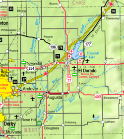
Haverhill is an unincorporated community in Butler County, Kansas, United States.[1] It is located about 4.5 miles (7.2 km) east of Augusta.
History[]
A post office was opened in Haverhill in 1880, and remained in operation until it was discontinued in 1933.[2]
Haverhill was a station and shipping point on the St. Louis–San Francisco Railway.[3]
Education[]
The community is served by Bluestem USD 205 public school district.
References[]
- ^ a b c d e Geographic Names Information System (GNIS) details for Haverhill, Kansas; United States Geological Survey (USGS); October 13, 1978.
- ^ "Kansas Post Offices, 1828-1961 (archived)". Kansas Historicall Society. Archived from the original on 9 October 2013. Retrieved 5 June 2014.
- ^ Blackmar, Frank Wilson (1912). Kansas: A Cyclopedia of State History, Embracing Events, Institutions, Industries, Counties, Cities, Towns, Prominent Persons, Etc. Standard Publishing Company. pp. 831.
Further reading[]
External links[]
Municipalities and communities of Butler County, Kansas, United States | ||
|---|---|---|
| Cities |  | |
| Unincorporated communities | ||
| Ghost towns | ||
| Townships | ||
| Footnotes | †This populated place is designated a Census-Designated Place (CDP) by the United States Census Bureau. ‡This populated place also has portions in an adjacent county or counties. | |
| ||
Categories:
- Unincorporated communities in Butler County, Kansas
- Unincorporated communities in Kansas
- Kansas geography stubs