Healdsburg, California
City of Healdsburg | |
|---|---|
City | |
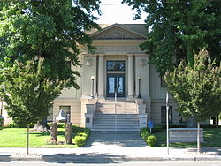 The Healdsburg Carnegie library, which now houses the Healdsburg Museum | |
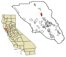 Location of Healdsburg in Sonoma County, California | |
 City of Healdsburg Location in California | |
| Coordinates: 38°37′3″N 122°51′59″W / 38.61750°N 122.86639°WCoordinates: 38°37′3″N 122°51′59″W / 38.61750°N 122.86639°W | |
| Country | |
| State | |
| County | Sonoma |
| Founded | 1857[2] |
| Incorporated | February 20, 1867[3] |
| Founded by | Harmon Heald |
| Government | |
| • Type | Council–manager |
| • Mayor | Evelyn Mitchell [1] |
| • Vice mayor | Osvaldo Jimenez [1] |
| Area | |
| • Total | 4.42 sq mi (11.45 km2) |
| • Land | 4.42 sq mi (11.45 km2) |
| • Water | 0.00 sq mi (0.00 km2) 0.15% |
| Elevation | 105 ft (32 m) |
| Population | |
| • Total | 11,254 |
| • Estimate (2019)[6] | 11,845 |
| • Density | 2,679.86/sq mi (1,034.79/km2) |
| Demonym(s) | Healdsburgians |
| Time zone | UTC-8 (Pacific) |
| • Summer (DST) | UTC-7 (PDT) |
| ZIP code | 95448 |
| Area code | 707 |
| FIPS code | 06-33056 |
| GNIS feature IDs | 277530, 2410726 |
| Website | cityofhealdsburg |


Healdsburg is a city located in Sonoma County, in California's Wine Country. At the 2010 census, the city had a population of 11,254. Healdsburg is a small tourist-oriented town in northern Sonoma County. Due to its three most important wine-producing regions (the Russian River, Dry Creek, and Alexander Valley AVAs), Healdsburg has been continuously awarded one of the top 10 small towns in America and is home to three of the top wineries in the United States.[8][9][10][11][12]
Healdsburg is centered on a 19th-century plaza that provides an important focal point for tourists and locals.[13]
History[]

Early inhabitants of the local area included the Pomo people, who constructed villages in open areas along the Russian River.[14] Anglo-American and Russian settlement may have commenced in the mid-19th century, with a settlement nearby, established downstream along the Russian River near Graton, in 1836, and later the Rancho Sotoyome land grant, in 1844.[15]
In 1857, Harmon Heald, an Ohio businessman who had been squatting on Rancho Sotoyome since 1850, purchased part of the rancho—giving the city its official founding date.[2] In 1867, Heald's eponymous small town was incorporated.[14] Healdsburg is located within the former township of Mendocino. The San Francisco and North Pacific Railroad reached Healdsburg in 1872.[16]
The Healdsburg Carnegie Library, now the Healdsburg Museum, is listed on the National Register of Historic Places, as is the Healdsburg Memorial Bridge.[17]
The City Council of Healdsburg has identified 13 important Historic Structures and Districts.
Farming, especially orchards and truck farms, was common within the present city limits from at least the 1890s to 1940s.[18]
Geography[]
The city has a total area of 4.464 sq mi (11.6 km2), of which 4.457 sq mi (11.5 km2) is land and 0.007 sq mi (0.0 km2) is water. The total area is 0.15% water.[19] It lies on the Russian River, near a point used as a crossing of the river since the 1850s that is now the site of the Healdsburg Memorial Bridge.[20]
Foss Creek traverses the city from north to south, flowing into Dry Creek near the U.S. 101 Central Healdsburg interchange.
Climate[]
Healdsburg has cool, wet winters and warm to hot, dry summers. In January, the average high temperature is 57.6 °F (14.2 °C) and the average low is 38 °F (3 °C). In July, the average high temperature is 88.8 °F (31.6 °C) and the average low is 52.7 °F (11.5 °C). There are an average of 54.6 days with highs of 90 °F (32 °C) or higher and an average of 20.1 days with lows of 32 °F (0 °C) or lower. The record high temperature was 116 °F (47 °C) on July 13, 1972, and the record low temperature was 14 °F (−10 °C) on December 22, 1990.[21]
Annual precipitation averages 42.2 in (1,070 mm). There are an average of 73 days annually with measurable precipitation. The wettest year was 1983 with 96.25 in (2,445 mm) and the driest year was 1976 with 13.67 in (347 mm). The most precipitation in one month was 29.9 in (760 mm) in January 1995. The most precipitation in 24 hours was 8.18 in (208 mm) on December 3, 1980. Snow is relatively rare, with none in most years. The highest yearly snowfall totaled 0.8 in (20 mm) in 1976.[22]
| hideClimate data for Healdsburg, California | |||||||||||||
|---|---|---|---|---|---|---|---|---|---|---|---|---|---|
| Month | Jan | Feb | Mar | Apr | May | Jun | Jul | Aug | Sep | Oct | Nov | Dec | Year |
| Average high °F (°C) | 57 (14) |
63 (17) |
67 (19) |
72 (22) |
78 (26) |
85 (29) |
89 (32) |
88 (31) |
86 (30) |
78 (26) |
66 (19) |
58 (14) |
74 (23) |
| Average low °F (°C) | 38 (3) |
40 (4) |
42 (6) |
44 (7) |
48 (9) |
51 (11) |
52 (11) |
52 (11) |
50 (10) |
47 (8) |
42 (6) |
38 (3) |
45 (7) |
| Average precipitation inches (mm) | 9.4 (240) |
7.3 (190) |
5.4 (140) |
2.5 (64) |
1.1 (28) |
0.3 (7.6) |
0 (0) |
0.1 (2.5) |
0.4 (10) |
2.1 (53) |
5.1 (130) |
7.6 (190) |
41.3 (1,050) |
| Source: Weatherbase [23] | |||||||||||||
Environment[]
An intrinsic element of the city's natural environment is the riparian zone associated with the Russian River that flows through Healdsburg. City residents support recycling by use of the Healdsburg Transfer Station. The city has shown an interest in creating a quiet environment by creating a Noise Element of the General Plan, which defines baseline sound level contours and sets forth standards of quiet for each land use category.
Demographics[]
| Historical population | |||
|---|---|---|---|
| Census | Pop. | %± | |
| 1860 | 334 | — | |
| 1870 | 959 | 187.1% | |
| 1880 | 1,133 | 18.1% | |
| 1890 | 1,485 | 31.1% | |
| 1900 | 1,869 | 25.9% | |
| 1910 | 2,011 | 7.6% | |
| 1920 | 2,412 | 19.9% | |
| 1930 | 2,296 | −4.8% | |
| 1940 | 2,507 | 9.2% | |
| 1950 | 3,258 | 30.0% | |
| 1960 | 4,816 | 47.8% | |
| 1970 | 5,438 | 12.9% | |
| 1980 | 7,217 | 32.7% | |
| 1990 | 9,469 | 31.2% | |
| 2000 | 10,722 | 13.2% | |
| 2010 | 11,254 | 5.0% | |
| 2019 (est.) | 11,845 | [6] | 5.3% |
| U.S. Decennial Census[24] | |||
2010[]
At the 2010 census Healdsburg had a population of 11,254. The population density was 2,521.3 people per square mile (973.5/km2). The racial makeup of Healdsburg was 8,334 (74.1%) White, 56 (0.5%) African American, 205 (1.8%) Native American, 125 (1.1%) Asian, 18 (0.2%) Pacific Islander, 2,133 (19.0%) from other races, and 383 (3.4%) from two or more races. Hispanic or Latino of any race were 3,820 persons (33.9%).[25]
The census reported that 99.5% of the population lived in households and 0.5% were institutionalized.
There were 4,378 households, 1,335 (30.5%) had children under the age of 18 living in them, 2,140 (48.9%) were opposite-sex married couples living together, 465 (10.6%) had a female householder with no husband present, 222 (5.1%) had a male householder with no wife present. There were 259 (5.9%) unmarried opposite-sex partnerships, and 54 (1.2%) same-sex married couples or partnerships. Of the households, 1,205 (27.5%) were one person and 542 (12.4%) had someone living alone who was 65 or older. The average household size was 2.56. There were 2,827 families (64.6% of households); the average family size was 3.12.
The age distribution was 2,546 people (22.6%) under the age of 18, 925 people (8.2%) aged 18 to 24, 2,750 people (24.4%) aged 25 to 44, 3,349 people (29.8%) aged 45 to 64, and 1,684 people (15.0%) who were 65 or older. The median age was 40.8 years. For every 100 females, there were 96.5 males. For every 100 females age 18 and over, there were 93.0 males.
There were 4,794 housing units at an average density of 1,074.0 per square mile (414.7/km2), of which 57.6% were owner-occupied and 42.4% were occupied by renters. The homeowner vacancy rate was 2.7%; the rental vacancy rate was 4.2%. Of the population, 53.2% lived in owner-occupied housing units and 46.3% lived in rental housing units.
2000[]
As of the 2000 census, there were 10,722 people in 3,968 households, including 2,702 families, in the city. The population density was 2,848/sq mi (1,101/km2). There were 4,138 housing units at an average density of 1,099/sq mi (425/km2). The racial makeup of the city was 79.9% White, 0.5% African American, 1.8% Native American, 0.8% Asian, 0.1% Pacific Islander, 13.4% from other races, and 3.5% from two or more races. Of the population, 28.8% were Hispanic or Latino of any race.
There were 3,968 households, 33.0% had children under the age of 18 living with them, 52.2% were married couples living together, 11.4% had a female householder with no husband present, and 31.9% were non-families. 25.9% of households were made up of individuals, and 12.1% had someone living alone who was 65 or older. The average household size was 2.69 and the average family size was 3.23.
The age distribution was 26.0% under the age of 18, 8.9% from 18 to 24, 26.5% from 25 to 44, 24.5% from 45 to 64, and 14.1% who were 65 or older. The median age was 37 years. For every 100 females, there were 95.0 males. For every 100 females age 18 and over, there were 90.8 males.
The median household income was $48,995 and the median family income was $55,386. Males had a median income of $38,977 versus $32,015 for females. The per capita income for the city was $22,245. 9.4% of the population and 6.6% of families were below the poverty line. Out of the total population, 10.4% of those under the age of 18 and 6.7% of those 65 and older were living below the poverty line.
Government[]
State and federal[]
In the California State Legislature, Healdsburg is in the 2nd Senate District, represented by Democrat Mike McGuire, and in the 2nd Assembly District, represented by Democrat Jim Wood.[26]
In the United States House of Representatives, Healdsburg is in California's 2nd congressional district, represented by Democrat Jared Huffman.[27]
According to the California Secretary of State, as of February 10, 2019, Healdsburg has 6,913 registered voters. Of those, 3,624 (52.4%) are registered Democrats, 1,262 (18.3%) are registered Republicans, and 1,680 (24.3%) have declined to state a political party.[28]
Transportation[]
Amtrak Thruway and Sonoma County Transit buses serve the Depot. Healdsburg is a proposed future stop on the Sonoma–Marin Area Rail Transit commuter rail line.
Notable people[]
This section needs additional citations for verification. (January 2015) |
- Mary Ellen Bamford: author
- Kristen Barnhisel, winemaker[29]
- Helen Beardsley: author
- Raymond Burr: actor[30]
- Jim Cullom: professional football player
- L Peter Deutsch: creator of Ghostscript
- Paul Erdman: business and financial writer
- Henry D. Fitch: early resident
- Jess Jackson: wine entrepreneur
- Roderick N. Matheson: early resident
- Patti McCarty: actress
- Mike McGuire: politician[31]
- Heidi Newfield: country singer, formerly of Trick Pony
- Thomas C. Reed: former Secretary of the Air Force
- Ariana Richards: actress and painter
- Ralph Rose: track and field athlete, Olympic gold medalist in 1904-08-12
- Jack Sonni: former guitarist of Dire Straits
- John Udell: diarist of the American frontier[32]
- John Carl Warnecke: architect
- Hazel Hotchkiss Wightman: tennis player, Wimbledon and Olympic champion
- Jim Wood: politician
See also[]
- Category:Healdsburg, California
- List of cities and towns in California
- List of cities and towns in the San Francisco Bay Area
- Madrona Manor
- Honor Mansion
- Sonoma County wine
- Wine Country (California)
References[]
- ^ Jump up to: a b "City Council". City of Healdsburg. Retrieved June 27, 2018.
- ^ Jump up to: a b Russell, Sharol (August 23, 2007). "Happy Birthday Healdsburg". Healdsburg Tribune. Healdsburg, California: Sonoma West Publishers. Retrieved April 18, 2008.[permanent dead link]
- ^ "California Cities by Incorporation Date". California Association of Local Agency Formation Commissions. Archived from the original (Word) on October 17, 2013. Retrieved August 25, 2014.
- ^ "2019 U.S. Gazetteer Files". United States Census Bureau. Retrieved July 1, 2020.
- ^ "Healdsburg (city) QuickFacts". United States Census Bureau. Archived from the original on April 16, 2015. Retrieved April 16, 2015.
- ^ Jump up to: a b "Population and Housing Unit Estimates". United States Census Bureau. May 24, 2020. Retrieved May 27, 2020.
- ^ "Healdsburg". Geographic Names Information System. United States Geological Survey.
- ^ "Top 10 small towns in America". Fox News. March 21, 2013. Archived from the original on August 16, 2015. Retrieved July 27, 2015.
1. Healdsburg, California
- ^ Sandra Ramani (March 19, 2013). "10 Best Small Towns in America". Fodor's. Retrieved July 27, 2015.
- ^ "2. Healdsburg, CA". Smithsonian. April 2014. Retrieved July 27, 2015.
- ^ "Healdsburg, California: 50 Best Places to Live in America". Men's Journal. March 27, 2015. Retrieved July 27, 2015.
- ^ "101 Best Wineries in America 2017 Slideshow". The Daily Meal. Retrieved June 19, 2018.
- ^ Hall, Matthew (October 23, 2006). "Business survey shows locals shop locally". Healdsburg Tribune. Healdsburg, California: Sonoma West Publishers. Retrieved April 18, 2008.[permanent dead link]
- ^ Jump up to: a b "Healdsburg, California Early History". Archived from the original on August 17, 2007. Retrieved September 3, 2007.
- ^ Healdsburg, California History Timeline
- ^ Stindt, Fred A. (1978). The Northwestern Pacific Railroad Redwood Empire Route (3rd ed.). Fred A. Stindt.
- ^ "National Register Information System". National Register of Historic Places. National Park Service. November 2, 2013.
- ^ Archives, Healdsburg Museum and Historical Society
- ^ "2010 Census U.S. Gazetteer Files – Places – California". United States Census Bureau.
- ^ National Register of Historic Places Registration Form for Healdsburg Memorial Bridge, California State Park System, accessed 2011-12-26.
- ^ "Western Regional Climate Center".
- ^ "WRCC precipitation records".
- ^ "Weatherbase: Historical Weather for Healdsburg, California". Weatherbase. 2013. Retrieved on April 26, 2013.
- ^ "Census of Population and Housing". Census.gov. Retrieved June 4, 2015.
- ^ "2010 Census Interactive Population Search: CA - Healdsburg city". U.S. Census Bureau. Archived from the original on July 15, 2014. Retrieved July 12, 2014.
- ^ "Statewide Database". UC Regents. Archived from the original on February 1, 2015. Retrieved December 3, 2014.
- ^ "California's 2nd Congressional District - Representatives & District Map". Civic Impulse, LLC. Retrieved March 1, 2013.
- ^ "CA Secretary of State – Report of Registration – February 10, 2019" (PDF). ca.gov. Retrieved March 12, 2019.
- ^ "Kristen Barnhisel". Winemakers A-Z. Women Winemakers of California. Retrieved December 23, 2012.
- ^ Podolsky, J. D. (September 27, 1993). "The Defense Rests". People. Archived from the original on September 13, 2015. Retrieved May 20, 2016.
- ^ "Biography: Senator Mike McGuire". State of California. Retrieved January 28, 2015.
- ^ Bowen, Jerry (August 25, 2002). "A perilous wagon-train trip west". Vacaville Reporter. Retrieved February 25, 2015.
External links[]
| Wikimedia Commons has media related to Healdsburg, California. |
| Wikivoyage has a travel guide for Healdsburg. |
| show Municipalities and communities of Sonoma County, California, United States |
|---|

| show San Francisco Bay Area |
|---|

| show Authority control |
|---|
- Healdsburg, California
- 1867 establishments in California
- California wine
- Cities in Sonoma County, California
- Cities in the San Francisco Bay Area
- Incorporated cities and towns in California
- Populated places established in 1857
- Populated places established in 1867