Henry Township, Fulton County, Indiana
Henry Township | |
|---|---|
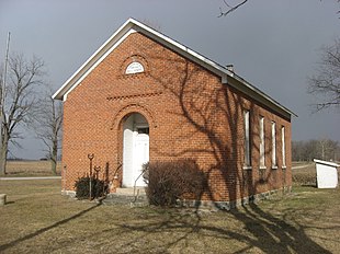 The Prill School, a museum in the township | |
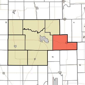 Location of Henry Township in Fulton County | |
| Coordinates: 41°02′23″N 86°03′13″W / 41.03972°N 86.05361°WCoordinates: 41°02′23″N 86°03′13″W / 41.03972°N 86.05361°W | |
| Country | United States |
| State | Indiana |
| County | Fulton |
| Government | |
| • Type | Indiana township |
| Area | |
| • Total | 46.75 sq mi (121.1 km2) |
| • Land | 46.45 sq mi (120.3 km2) |
| • Water | 0.3 sq mi (0.8 km2) |
| Elevation | 833 ft (254 m) |
| Population (2010) | |
| • Total | 3,048 |
| • Density | 65.6/sq mi (25.3/km2) |
| FIPS code | 18-33106[2] |
| GNIS feature ID | 453406 |
Henry Township is one of eight townships in Fulton County, Indiana. As of the 2010 census, its population was 3,048 and it contained 1,224 housing units.[3]
History[]
The Prill School and Utter-Gerig Round Barn are listed on the National Register of Historic Places.[4]
Geography[]
According to the 2010 census, the township has a total area of 46.75 square miles (121.1 km2), of which 46.45 square miles (120.3 km2) (or 99.36%) is land and 0.3 square miles (0.78 km2) (or 0.64%) is water.[3]
Cities and towns[]
Unincorporated towns[]
(This list is based on USGS data and may include former settlements.)
Adjacent townships[]
- Franklin Township, Kosciusko County (north)
- Seward Township, Kosciusko County (northeast)
- Pleasant Township, Wabash County (east)
- Perry Township, Miami County (southeast)
- Allen Township, Miami County (southwest)
- Rochester Township (west)
- Newcastle Township (northwest)
Major highways[]
Cemeteries[]
The township contains two cemeteries: Independent Order of Odd Fellows and Mount Hope Athens.
Education[]
Henry Township residents may obtain a free library card from the Akron Carnegie Public Library in Akron.[5]
References[]
- "Henry Township, Fulton County, Indiana". Geographic Names Information System. United States Geological Survey. Retrieved 2009-09-24.
- United States Census Bureau cartographic boundary files
- ^ "US Board on Geographic Names". United States Geological Survey. 2007-10-25. Retrieved 2008-01-31.
- ^ "U.S. Census website". United States Census Bureau. Retrieved 2008-01-31.
- ^ a b "Population, Housing Units, Area, and Density: 2010 - County -- County Subdivision and Place -- 2010 Census Summary File 1". United States Census. Archived from the original on 2020-02-12. Retrieved 2013-05-10.
- ^ "National Register Information System". National Register of Historic Places. National Park Service. July 9, 2010.
- ^ "Library Access and Circulation Policy". Akron Carnegie Public Library. Retrieved 7 March 2018.
External links[]
Municipalities and communities of Fulton County, Indiana, United States | ||
|---|---|---|
| City | ||
| Towns | ||
| Townships | ||
| Unincorporated communities | ||
| Footnotes | ‡This populated place also has portions in an adjacent county or counties | |
| ||
This Fulton County, Indiana location article is a stub. You can help Wikipedia by . |
- Townships in Fulton County, Indiana
- Townships in Indiana
- Michiana Region, Indiana geography stubs