Hnojné
Hnojné | |
|---|---|
Municipality | |
 | |
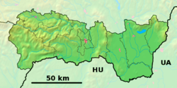 Hnojné Location of Hnojné in the Košice Region | |
| Coordinates: 48°47′0″N 22°4′0″E / 48.78333°N 22.06667°ECoordinates: 48°47′0″N 22°4′0″E / 48.78333°N 22.06667°E | |
| Country | |
| Region | Košice |
| District | Michalovce |
| First mentioned | 1390 |
| Area | |
| • Total | 6.811 km2 (2.630 sq mi) |
| Elevation | 108 m (354 ft) |
| Population | |
| • Total | 250 |
| • Density | 37/km2 (95/sq mi) |
| Time zone | UTC+1 (CET) |
| • Summer (DST) | UTC+2 (CEST) |
| Postal code | 072 33 |
| Area code(s) | 421-56 |
| Car plate | MI |
| Website | www |


Hnojné is a village and municipality in Michalovce District in the Kosice Region of eastern Slovakia.
History[]
In historical records the village was first mentioned in 1390.
Geography[]
The village lies at an altitude of 108 metres and covers an area of 6.811 km². It has a population of about 250 people.
Ethnicity[]
The population is about 99% Slovak in ethnicity.
Culture[]
The village has a small public library and food stores.
Transport[]
The nearest railway station is 17 kilometres away at Michalovce.
Genealogical resources[]
The records for genealogical research are available at the state archive "Statny Archiv in Presov, Slovakia"
- Greek Catholic church records (births/marriages/deaths): 1805-1937 (parish B)
Gallery[]

Church of the Transfiguration of the Lord in Hnojné

Church of the Transfiguration of the Lord in Hnojné


See also[]
External links[]
| Wikimedia Commons has media related to Hnojné. |
- Official website

- https://web.archive.org/web/20071116010355/http://www.statistics.sk/mosmis/eng/run.html
- Surnames of living people in Hnojne
This Michalovce District geography article is a stub. You can help Wikipedia by . |
- Villages and municipalities in Michalovce District
- Michalovce District geography stubs