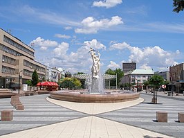
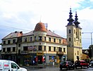
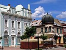
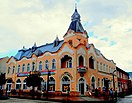
Michalovce
Michalovce | |
|---|---|
Town | |
      | |
 Coat of arms | |
| Etymology: St Michael | |
 Michalovce Location of Michalovce within Slovakia | |
| Coordinates: 48°45′19″N 21°54′48″E / 48.75528°N 21.91333°ECoordinates: 48°45′19″N 21°54′48″E / 48.75528°N 21.91333°E | |
| Country | Slovakia |
| Region | Košice |
| District | Michalovce |
| First mentioned | 1244 |
| Government | |
| • Mayor | Viliam Záhorčák (Smer-SD) |
| Area | |
| • Total | 52.807 km2 (20.389 sq mi) |
| Elevation | 115 m (377 ft) |
| Population (2018-12-31[1]) | |
| • Total | 39,050 |
| • Density | 740/km2 (1,900/sq mi) |
| Time zone | UTC+1 (CET) |
| • Summer (DST) | UTC+2 (CEST) |
| Postal code | 071 01 |
| Area code(s) | 421-56 |
| Car plate | MI |
| Website | http://www.michalovce.sk |

Michalovce (![]() pronunciation (help·info); Hungarian: Nagymihály, German: Großmichel, Romani: Mihalya, Yiddish: Mikhaylovets or Mykhaylovyts; Ukrainian: Михайлівці) is a town on the Laborec river in eastern Slovakia. Originally named after the Archangel St Michael,[2] it is the second-largest city in the Košice Region and the seat of the Michalovce District.
pronunciation (help·info); Hungarian: Nagymihály, German: Großmichel, Romani: Mihalya, Yiddish: Mikhaylovets or Mykhaylovyts; Ukrainian: Михайлівці) is a town on the Laborec river in eastern Slovakia. Originally named after the Archangel St Michael,[2] it is the second-largest city in the Košice Region and the seat of the Michalovce District.
The city is located on the shore of Lake Sirava, approximately 360 kilometres (224 miles) east of the capital Bratislava and immediately adjacent to the border with Ukraine. Michalovce is mostly recognized for its adjacent lakes and volcanic mountains, which generates tourism, and for agriculture as well as the passing Druzhba pipeline. According to the latest census, the population of the town stood at 40,255, with a metropolitan population of 109,121, which ranks it among the largest population centers in eastern Slovakia.
History[]
Early history[]
The city of present-day Michalovce along with the adjacent lowlands was settled in from the Palaeolithic era. Archaeologists have found prehistoric Homo sapiens skeletons in the region, as well as numerous objects and vestiges by the foot of the Vihorlat mountains, dating from the Neolithic.[3] During the Late Bronze Age, which meant the period of processing bronze as the main metal, the surrounding area was an important cultural and trading center within the Carpathian Basin and, together with the area of the southern Tisa River Basin, played an important part forging relations with areas outside of the Carpathians. The history of Michalovce was significantly influenced by presence of Celtic tribes, starting from the Gallic expansions in the 4th century BC, and later by the Romans.[4]
Slovak historians claim that Slavs arrived in the area in the fifth century,[citation needed] first being a part of the empire of the Avars. Although there is no evidence, Slovak historians claim that the area was part of the Great Moravian empire[citation needed] in the ninth century. It is probably unlikely. The town of Michalovce is the place where the legendary Prince Laborec died and was buried according to legends. From the tenth century onwards, the region was part of Hungary. However, when the Magyar tribes arrived in the late 800s, the entire region was sparsely populated and there were few actual settlements. Much of Slovak history is based on conjecture, legends and nationalism.
After the Ottoman conquest in south central Hungary in the sixteenth century, Hungary was divided, and present-day Michalovce became part of the Eastern Hungarian Kingdom, and later Royal Hungary. The town grew significantly in the eighteenth and nineteenth centuries. Since the Austrian-Hungarian Ausgleich of 1867, it achieved the status of a large community, and shortly afterward became the seat of one of the districts of Zemplén County.[5]
Modern history[]
The 19th century brought back significant development of the town. In 1828, there were 49 craftsman workshops representing all 22 kinds of craft production of the crafts licences in the region of Zemplin. Until 1874 there were a few industrial factories of local importance in the surroundings of Michalovce (starch factories, distilleries, mill-houses, brickworks) with a limited number of work opportunities. The construction of the railway linking Michalovce with Medzilaborce in 1874, as well as the construction of the first railway linking Hungary with Galicia in 1871, had a profound impact on the production, business, and regional development in and around Michalovce.
More food-processing factories and industrial factories – a brewery, two brickworks and a steam millhouse – were established. Starting in 1876 doctors were employed in the town, as the Štefan Kukura Hospital was established that year. In 1896 the Hungarian language newspaper Felso Zemplén was published. In 1805 a common school is founded, which later changed into a state school. In 1804, a post office was established, and in 1873 a printing office was established.
In 1885, by a decision of the municipal council, a fire brigade was founded, and the first public lighting was provided. Unemployment, being a widespread side-effect of the 18th century, resulted in the emigration of mainly farmers. Many left to seek work in the coal mining industry in Pennsylvania, United States, giving rise to a large Rusyn American community there.
After World War I, in 1918 (confirmed by the Treaty of Trianon in 1920), Michalovce, along with some other parts of Zemplén County, became part of the then-formed Czechoslovakia. In late summer and early autumn (August/September) 1944, 3500 Jewish inhabitants were deported from Michalovce. Since 1993, with the breakup of Czechoslovakia, Michalovce has been part of Slovakia. In 1996 it was made the seat of the Michalovce District.
The previous agricultural character of Michalovce was changed by a number of newly established industrial factories after 1945. In the 1950s and 1960s, factories processing agricultural products, and textile, engineering and construction companies arose. These included Agricultural Business and Supply Company, East-Slovak Dairy, East-Slovak Bakery and Confectionery, Slovak Malt Plant, East-Slovak Poultry Plant, Clothing Company and Odeta, a production company. During the early 1960s, construction of the Druzhba pipeline was a major source of employment.
Geography[]
The town lies in the Košice Region, in the Eastern Slovak Lowland on the Laborec river, historically belonging to Zemplén County. The town is about 48 km (30 mi) east of Košice and 30 km (19 mi) west of Uzhhorod, Ukraine. Geographical features nearby include the Vihorlat Mountains and the Zemplínska šírava lake. Nearby is the biggest lake of the Vihorlat Mountains, Morské oko, Vinné castle and Vinné lake.
Demographics[]
In 1910, Michalovce had 6120 residents, of whom 3792 were Hungarian, 1586 Slovak and 542 German. The religious makeup was 38.6% Roman Catholic, 32.3% Jewish and 23.2% Greek Catholic. After World War II, due to the Presidential Benes decrees, almost the entire population of the region's ethnic Hungarians and Germans (including the region's native Carpathian Germans) were forcibly expelled. Those remaining were assimilated and subjected to Slovakization.[6]
According to the 2001 census, the town had 39,948 inhabitants. 94.57% were Slovaks, 2.24% were Roma, 0.73% were Czechs and 0.47% were Ukrainian.[7] The religious makeup was 53.92% Roman Catholics, 19.65% Greek Catholics, 9.73% people with no religious affiliation and 5.19% Orthodox.[7]
According to the 2011 census, the town had 40,027 inhabitants. 79.53% of the inhabitants were Slovaks, 3.09% were Roma, 0.39% were Czechs and 0.36% were Ukrainians. 15.47% did not specify a nationality.[8] The religious makeup was 42.07% Roman Catholics, 16.50% Greek Catholics, 3.96% Orthodox, 3.97% Evangelicals, 10.33% with no religious affiliation and 18.30% who did not specify affiliation.[8]
Education[]
The city of Michalovce is home to many secondary schools and some university colleges. Of the seven secondary schools, the most well-known and prestigious is the Pavol Horov Gymnasium. The other gymnasium is Gymnazium na ulici Ľudovita Štúra 26.
Health care[]
The largest health care provider in the municipality is the Štefan Kukura Hospital in Michalovce, with 712 beds.
Twin towns — sister cities[]
Michalovce is twinned with:[9]
 Cognac, France
 Jarosław, Poland
 Kavarna, Bulgaria
 Liptovský Mikuláš, Slovakia
 Pančevo, Serbia
 Sátoraljaújhely, Hungary
 Uzhorod, Ukraine
 Villarreal, Spain
 Vyškov, Czech Republic
Notable people[]
- Aurél Dessewffy
- Presian, son of the Bulgarian tsar Ivan Vladislav (the gravestone of a certain "Prince Presian" was found in Michalovce)
- Emília Sičáková-Beblavá
- Volodymyr Sichynskyi
References[]
- Notes
- ^ "Population and migration". Statistical Office of the Slovak Republic. Retrieved 2019-04-16.
- ^ "Michalovce celebrates its namesakes". sme.sk. October 2011. Retrieved 20 August 2013.
- ^ "Early graves from 'Neolithic period' in Carpathian Basin are in fact 6000 years younger". Journal of Human Genetics. 57: 467–469. 7 June 2012. doi:10.1038/jhg.2012.36. Retrieved 30 July 2013.
- ^ Rustoiu, Aurel. "The Celts and Indigenous Populations from the Southern Carpathian Basin. Intercommunity Communication Strategies". Iron age rites and Rituals in the Carpathians Basin. www.Academia.edu. Retrieved 30 July 2013.
- ^ "Town history". Municipality of Michalovce. 2007. Retrieved 18 June 2009.
- ^ "Ethnic cleansing in post world war II Czechoslovakia: The presidential decrees of Edward Benes, 1945-1948". Human rights for minorities in Central Europe. Migration citizenship education. Archived from the original on 3 March 2012. Retrieved 30 July 2013.
- ^ Jump up to: a b "Municipal Statistics". Statistical Office of the Slovak republic. Archived from the original on 2007-11-16. Retrieved 2007-12-09.
- ^ Jump up to: a b "Nationality" (PDF). Statisticky Urad SR. Archived from the original (PDF) on 14 November 2013. Retrieved 12 July 2013.
- ^ "Družobné mestá" (in Slovak). Michalovce. Retrieved 2019-09-02.
External links[]
| Wikimedia Commons has media related to Michalovce. |
- Michalovce - Official city website
- Michalovce - detailed map guide
- Michalovce - ShtetLink
- Michalovce - photographs and information (in Polish)
| show Municipalities of Michalovce District |
|---|
| show Authority control |
|---|
- Villages and municipalities in Michalovce District
- Cities and towns in Slovakia
- Shtetls
- Romani communities in Slovakia
- Czech communities
- Holocaust locations in Czechoslovakia