Horná Ves, Prievidza District
Horná Ves | |
|---|---|
Municipality | |
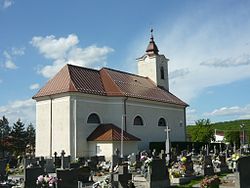 Church of the Conversion of Saint Paul | |
 Horná Ves Location of Horná Ves in the Trenčín Region | |
| Coordinates: 48°36′30″N 18°29′30″E / 48.60833°N 18.49167°ECoordinates: 48°36′30″N 18°29′30″E / 48.60833°N 18.49167°E | |
| Country | |
| Region | Trenčín |
| District | Prievidza |
| First mentioned | 1293 |
| Area | |
| • Total | 18.569 km2 (7.170 sq mi) |
| Elevation | 286 m (938 ft) |
| Population | |
| • Total | 1,080 |
| • Density | 58/km2 (150/sq mi) |
| Postal code | 972 48 |
| Area code(s) | 421-46 |
| Car plate | PD |
| Website | www.hornaves.sk |


Horná Ves (Hungarian: Ófelfalu) is a village and municipality in Prievidza District in the Trenčín Region of western Slovakia.
History[]
In historical records the village was first mentioned in 1293.
Geography[]
The municipality lies at an altitude of 286 metres and covers an area of 18.569 km². It has a population of about 1080 people.
Genealogical resources[]
The records for genealogical research are available at the state archive "Statny Archiv in Nitra, Slovakia"
- Roman Catholic church records (births/marriages/deaths): 1688-1896 (parish A)
See also[]
External links[]
![]() Media related to Horná Ves (Prievidza District) at Wikimedia Commons
Media related to Horná Ves (Prievidza District) at Wikimedia Commons
- Official website

- https://web.archive.org/web/20080111223415/http://www.statistics.sk/mosmis/eng/run.html
- Surnames of living people in Horna Ves
This Trenčín District location article is a stub. You can help Wikipedia by . |
Categories:
- Villages and municipalities in Prievidza District
- Trenčín geography stubs