Houston County, Texas
Houston County | |
|---|---|
U.S. county | |
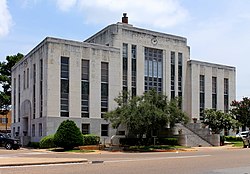 The Houston County Courthouse in Crockett is located at the intersections of Texas State Highway 21 and U.S. Highway 287. | |
 Location within the U.S. state of Texas | |
 Texas's location within the U.S. | |
| Coordinates: 31°19′N 95°26′W / 31.32°N 95.43°W | |
| Country | |
| State | |
| Founded | 1837 |
| Named for | Sam Houston |
| Seat | Crockett |
| Largest city | Crockett |
| Area | |
| • Total | 1,237 sq mi (3,200 km2) |
| • Land | 1,231 sq mi (3,190 km2) |
| • Water | 5.7 sq mi (15 km2) 0.5%% |
| Population (2020) | |
| • Total | 22,968 |
| • Density | 19/sq mi (7/km2) |
| Time zone | UTC−6 (Central) |
| • Summer (DST) | UTC−5 (CDT) |
| Congressional district | 8th |
| Website | www |

Houston County is a county located in the U.S. state of Texas. As of the 2010 census, its population was 23,732.[1] Its county seat is Crockett.[2] Houston County was one of 46 entirely dry counties in the state of Texas, until voters in a November 2007 special election legalized the sale of alcohol in the county.
Houston County was the first new county created under the 9-year Republic of Texas on June 12, 1837. The original boundaries of Houston County also included all of present-day Anderson and Trinity Counties, and portions of present-day Henderson and Polk Counties.
The county is named for Sam Houston, President of the Republic of Texas and Governor of Texas.[3] Other than being named for the same person, Houston County is not related to the City of Houston, which is located about 100 mi (160 km) to the south, in Harris County.
A county historical museum is located in a former railroad depot, located on First Street in Crockett.
History[]

Samuel Cartmill Hiroms (1836–1920) was born in present-day Polk County, his parents having been among Stephen F. Austin's "Old 300" families. Hiroms was an educator and a surveyor, who served in the Confederate Army. His second wife Emily Ann (née Johnston, 1853–1948) and he settled in the Creek community of Houston County. Their homestead was adjacent to what is now the Austonio Baptist Church on State Highway 21 in Austonio, Texas.[4]
Collin Aldrich (1801–1842) was a veteran of the Battle of San Jacinto, and was the first judge in Houston County, having served during the Republic of Texas from 1837 to 1841.[5]
Eli Coltharp established his Coltharp Hill in Houston County near Kennard. The store, post office, gristmill, cotton gin, blacksmith shop, and millinery shop were located on the stagecoach route west of Nacogcoches in Houston County. When the railroad bypassed the Contharp community, many of the residents relocated to work at a nearby sawmill.[6]
James Murphy Hager of Kentucky and his wife Nacoma (née Clark) established the Hagerville community in the 1840s. Hager was a farmer, cabinet maker, and blacksmith. The stagecoach from Nacogdoches to Navasota ran beside the Hagers' log home. One of the Hager sons donated land for a church and a school. A post office was at Hagerville from 1891 to 1905.[6]
The Four C Mill operated in Houston County during the first two decades of the 20th century. R. M. Keith, agent of the Central Coal and Coke Company in Kansas City, Missouri, began buying virgin timber in the fall of 1899. Lumber to construct the new mill was cut by a small sawmill purchased in early 1901 from J. H. Ratcliff. Keith organized the Louisiana and Texas Lumber Company to operate the Four C. The mill was producing 300,000 board feet of lumber daily by June 1902. Ratcliff Lake, now a United States Department of Interior recreational site, was the millpond for the Four C. The Texas Southeastern Railroad laid track from Lufkin to haul out the lumber. The town of Ratcliff was separated from the Four C by a fence, built to discourage the mill workers from spending their money outside the company town. The 120,000 acres were in time exhausted, and by 1920, the mill shut down.[6]
Geography[]

According to the U.S. Census Bureau, the county has a total area of 1,237 square miles (3,200 km2), of which 1,231 square miles (3,190 km2) are land and 5.7 square miles (15 km2) (0.5%) are covered by water.[7]
Adjacent counties[]
- Anderson County (north)
- Cherokee County (northeast)
- Angelina County (east)
- Trinity County (southeast)
- Walker County (south)
- Madison County (southwest)
- Leon County (west)
National protected area[]
Demographics[]

| Historical population | |||
|---|---|---|---|
| Census | Pop. | %± | |
| 1850 | 2,721 | — | |
| 1860 | 8,058 | 196.1% | |
| 1870 | 8,147 | 1.1% | |
| 1880 | 16,702 | 105.0% | |
| 1890 | 19,360 | 15.9% | |
| 1900 | 25,452 | 31.5% | |
| 1910 | 29,564 | 16.2% | |
| 1920 | 28,601 | −3.3% | |
| 1930 | 30,017 | 5.0% | |
| 1940 | 31,137 | 3.7% | |
| 1950 | 22,825 | −26.7% | |
| 1960 | 19,276 | −15.5% | |
| 1970 | 17,855 | −7.4% | |
| 1980 | 22,299 | 24.9% | |
| 1990 | 21,375 | −4.1% | |
| 2000 | 23,185 | 8.5% | |
| 2010 | 23,732 | 2.4% | |
| 2019 (est.) | 22,968 | [8] | −3.2% |
| U.S. Decennial Census[9] 1850–2010[10] 2010–2014[1] | |||
As of the census[11] of 2000, 23,185 people, 8,259 households, and 5,756 families were residing in the county. The population density was 19 people per mi2 (7/km2); it had the second-lowest population density for all counties in Deep East Texas, behind only Newton County. The 10,730 housing units averaged 9 per mi2 (3/km2). The racial makeup of the county was 68.57% White, 27.93% African American, 0.26% Native American, 0.25% Asian, 2.23% from other races, and 0.76% from two or more races. About 7.50% of the population were Hispanics or Latinos of any race.
Of the 8,259 households, 28.70% had children under the age of 18 living with them, 51.90% were married couples living together, 14.20% had a female householder with no husband present, and 30.30% were notfamilies. About 27.90% of all households were made up of individuals, and 15.10% had someone living alone who was 65 years of age or older. The average household size was 2.44, and the average family size was 2.97.
In the county, the age distribution was 23.20% under 18, 6.80% from 18 to 24, 27.70% from 25 to 44, 24.30% from 45 to 64, and 18.00% who were 65 or older. The median age was 40 years. For every 100 females, there were 114.10 males. For every 100 females age 18 and over, there were 115.90 males.
The median income for a household in the county was $28,119, and for a family was $35,033. Males had a median income of $29,143 versus $19,885 for females. The per capita income for the county was $14,525. About 15.60% of families and 21.00% of the population were below the poverty line, including 28.30% of those under age 18 and 18.20% of those age 65 or over.
Government and infrastructure[]
Eastham Unit, a Texas Department of Criminal Justice prison for men, is located in an unincorporated area in the county.[12]
The Crockett State School, a Texas Youth Commission juvenile correctional facility for boys, was located in Crockett.[13] but was closed on August 31, 2011.[14]
Chuck Hopson, a pharmacist from Jacksonville, is a Republican and the member of the Texas House of Representatives, whose District 11 includes Houston County.
Transportation[]
Major highways[]
 U.S. Highway 287
 State Highway 7
 State Highway 19
 State Highway 21
Houston County is served by US Highway 287 and State Highways 7, 19, and 21. All of these highways intersect at the Courthouse Square in downtown Crockett. SH 21 follows the 300-year-old route of Old San Antonio Road. Texas State Highway Loop 304 circles the city of Crockett.
Rail[]
Freight rail service is provided by Union Pacific Railroad. The Crockett Depot, built in 1909, has been restored and now serves as the Houston County Museum.
Air[]
Houston County Airport (KDKR), located 3 miles east of Crockett on SH 7, features a 4,000-foot runway. On-site aircraft services are provided by East Texas Aircraft.
Public transportation[]
Demand and response public transportation within Houston County is provided by Brazos Transit District.
Communities[]
Cities[]
Unincorporated communities[]
- Abe
- Allen Chapel
- Arbor Grove
- Ash
- Augusta
- Austonio
- Belott
- Center Grove
- Center Hill
- Cooper
- Creek
- Cut
- Germany
- Holly
- Hopewell
- Mapleton
- Mound City (partly in Anderson County)
- Mount Vernon
- Pennington (partly in Trinity County)
- Porter Springs
- Ratcliff
- Refuge
- San Pedro
- Sand Ridge
- Shady Grove
- Smith Grove
- Volga
- Weches
- Weldon
Ghost towns[]
Education[]
Five school districts are located entirely in the county:
- Crockett Independent School District
- Lovelady Independent School District
- Kennard Independent School District
- Latexo Independent School District
- Grapeland Independent School District
In addition, small portions of Groveton Independent School District and Elkhart Independent School District, located in Trinity County and Anderson County, respectively, extend into Houston County.
The county is in the district for Angelina College.[16]
See also[]
- Museums in East Texas
- National Register of Historic Places listings in Houston County, Texas
- Recorded Texas Historic Landmarks in Houston County
- Wet counties
References[]
- ^ Jump up to: a b "State & County QuickFacts". United States Census Bureau. Archived from the original on October 18, 2011. Retrieved December 17, 2013.
- ^ "Find a County". National Association of Counties. Archived from the original on 2011-05-31. Retrieved 2011-06-07.
- ^ Gannett, Henry (1905). The Origin of Certain Place Names in the United States. Govt. Print. Off. pp. 161.
- ^ Texas Historical Commission, Historic Marker, Autonio, Texas
- ^ Texas Historical Commission, Historic Marker, Houston County, State Highway 21
- ^ Jump up to: a b c Texas Historical Commission, Historic Marker, Houston County, Texas, east of Kennard, Texas
- ^ "2010 Census Gazetteer Files". United States Census Bureau. August 22, 2012. Retrieved April 30, 2015.
- ^ "Population and Housing Unit Estimates". United States Census Bureau. May 24, 2020. Retrieved May 27, 2020.
- ^ "U.S. Decennial Census". United States Census Bureau. Retrieved April 30, 2015.
- ^ "Texas Almanac: Population History of Counties from 1850–2010" (PDF). Texas Almanac. Retrieved April 30, 2015.
- ^ "U.S. Census website". United States Census Bureau. Retrieved 2011-05-14.
- ^ "Eastham Unit Archived 2010-07-25 at the Wayback Machine." Texas Department of Criminal Justice. Retrieved on July 16, 2010.
- ^ "Crockett State School Archived 2011-02-20 at the Wayback Machine." Texas Youth Commission. Retrieved on August 8, 2010,
- ^ "TYC Announces Closure of Three Facilities Archived 2012-03-05 at the Wayback Machine." Texas Youth Commission. Retrieved on July 3, 2011.
- ^ Leip, David. "Dave Leip's Atlas of U.S. Presidential Elections". uselectionatlas.org. Retrieved 2018-07-25.
- ^ Texas Education Code, Sec. 130.165. ANGELINA COUNTY JUNIOR COLLEGE DISTRICT SERVICE AREA..
External links[]
| Wikimedia Commons has media related to Houston County, Texas. |
| Wikisource has the text of an 1879 American Cyclopædia article about Houston County, Texas. |
- Houston County government's website
- Houston County from the Handbook of Texas Online
- Crockett Community Website
- Crockett Area Chamber of Commerce Preview
- Houston County and Crockett Area Chamber of Commerce
| show Places adjacent to Houston County, Texas |
|---|
| show Municipalities and communities of Houston County, Texas, United States |
|---|


Coordinates: 31°19′N 95°26′W / 31.32°N 95.43°W
| show Authority control |
|---|
- Texas counties
- Houston County, Texas
- 1837 establishments in the Republic of Texas
- Populated places established in 1837
- Sam Houston