Hulu Langat District
Hulu Langat District | |
|---|---|
| Daerah Hulu Langat | |
| Other transcription(s) | |
| • Jawi | دايره هولو لاڠت |
| • Chinese | 乌鲁冷岳县 |
| • Tamil | உலு லங்காட் |
 Location of Hulu Langat District in Selangor | |
 Hulu Langat District Location of Hulu Langat District in Malaysia | |
| Coordinates: 3°05′N 101°50′E / 3.083°N 101.833°ECoordinates: 3°05′N 101°50′E / 3.083°N 101.833°E | |
| Country | |
| State | |
| Seat | Bandar Baru Bangi |
| Local area government(s) | Kajang Municipal Council (South) Ampang Jaya Municipal Council (North) |
| Government | |
| • District officer | Zul-Kefli@Zulkefli Khalid[1] |
| Area | |
| • Total | 829.44 km2 (320.25 sq mi) |
| Population (2010)[3] | |
| • Total | 1,067,744 |
| • Density | 1,300/km2 (3,300/sq mi) |
| Time zone | UTC+8 (MST) |
| • Summer (DST) | UTC+8 (Not observed) |
| Postcode | 43xxx, 55xxx, 56xxx, 68xxx |
| Calling code | +6-03-4, +6-03-8, +6-03-9 |
| Vehicle registration plates | B |

The Hulu Langat District is a district located in the southeastern corner of Selangor, between Kuala Lumpur and Negeri Sembilan.
Hulu Langat is the fifth largest district in Selangor State with an area of 840 square kilometres and a population of 1,141,880 at the 2010 Census (provisional result). It has a mix of urban and rural settlements with a majority of the population settling in towns near Kuala Lumpur. These population centers, such as Cheras and Ampang effectively became suburbs of the greater metropolitan area (both Cheras and Ampang are communities now divided administratively between Kuala Lumpur Federal Territory and Selangor State).
Hulu Langat has a median income of RM4060 (2016), which is significantly lower than the state average of RM7225 (2016). This district also has a higher poverty rate compared to the state and national average as of 2016.[4][5]
Population[]
According to the Population and Housing Census Malaysia 2000, Hulu Langat's population increased from 177,900 in 1980 to 413,900 in 1991 and 864,451 in 2000 and 1,067,744 (excluding foreigners) in 2010.[citation needed]
The following is based on Department of Statistics Malaysia 2010 census.[3]
| Ethnic groups in Hulu Langat , 2010 census | ||
|---|---|---|
| Ethnicity | Population | Percentage |
| Bumiputera | 586,658 | 55.1% |
| Chinese | 355,741 | 33.3% |
| Indian | 113,808 | 10.7% |
| Others | 11,537 | 1.0% |
| Total | 1,067,744 | 100% |
Administrative divisions[]

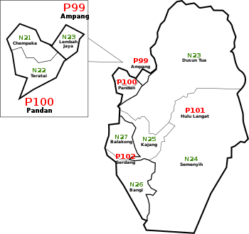
Hulu Langat District is divided into 7 mukims, which are:[6]
|

|
Local Area Government[]
- Ampang Jaya Municipal Council (Mukim Ampang only)
- Kajang Municipal Council (Most part of the district except Mukim Ampang)
Federal Parliament and State Assembly Seats[]
List of Hulu Langat district representatives in the Federal Parliament (Dewan Rakyat)
| Parliament | Seat Name | Member of Parliament | Party |
|---|---|---|---|
| P99 | Ampang | Zuraida Kamarudin | Perikatan Nasional (BERSATU) |
| P100 | Pandan | Wan Azizah Wan Ismail | Pakatan Harapan (PKR) |
| P101 | Hulu Langat | Hasanuddin Mohd Yunus | Pakatan Harapan (AMANAH) |
| P102 | Bangi | Ong Kian Ming | Pakatan Harapan (DAP) |
List of Hulu Langat district representatives in the State Legislative Assembly (Dewan Undangan Negeri)
| Parliament | State | Seat Name | State Assemblyman | Party |
|---|---|---|---|---|
| P99 | N20 | Lembah Jaya | Haniza Mohamed Talha | Perikatan Nasional (BERSATU) |
| P100 | N21 | Pandan Indah | Izham Hashim | Pakatan Harapan (PKR) |
| P100 | N22 | Teratai | Lai Wai Chong | IND |
| P101 | N23 | Dusun Tua | Edry Faizal | Pakatan Harapan (DAP) |
| P101 | N24 | Semenyih | Zakaria Hanafi | Barisan Nasional (UMNO) |
| P102 | N25 | Kajang | Hee Loy Sian | Pakatan Harapan (PKR) |
| P102 | N26 | Sungai Ramal | Mazwan Bin Johar | Pakatan Harapan (PKR) |
| P102 | N27 | Balakong | Wong Siew Ki | Pakatan Harapan (DAP) |
Infrastructure[]
Public transportation[]
The recently-opened MRT Sungai Buloh-Kajang Line runs through areas in this district, previously not served by any railway service. The MRT stations under this district are Taman Suntex, Sri Raya, Bandar Tun Hussein Onn, Batu 11 Cheras, Bukit Dukung, Sungai Jernih, Stadium Kajang, and Kajang station which is the southern terminal of the MRT SBK line, is also an interchange with the KTM Komuter Seremban Line.
Highways[]
The constituency is served by the Kuala Lumpur–Seremban Expressway, the Cheras–Kajang Expressway and the Kajang Dispersal Link Expressway (Silk Highway) with essential links to other major highways.
Places of interest[]
Hulu Langat town is famous for its durians. This town is also popular for its recreational activities and natural surroundings. Due to its near location to the city of Kuala Lumpur Hulu Langat is a popular spot to the local tourist for recreational activities. Among the popular spots of eco-tourism are the Sungai Gabai Waterfalls, the Semenyih Water Reservoir and the Congkak River Forest Recreational Center. Another latest hot spot for tourism is the Sungai Lopoh, located at 22nd Mile of Jalan Hulu Langat and the Kuala Lumpur Look Out Point Tourist Complex, located at Jalan Ampang–Hulu Langat. Near Sg Lui, Hulu Langat lays a famous malay residents named Shahid Ramlee Mansion, which was once before settled by Tan Sri P.Ramlee, Malaysia 70s famous actor.
Near Lembah Pangsun lies Mount Nuang (1,483m)a training ground for hikers and runners before they climb Mount Kinabalu or do a marathon. There are two hots spring in Hulu Langat one is Dusun Tua Hot Spring located at 16th mile and Sungai Serai Hot Spring .
Balakong consists of various shopping malls that are frequented by tourists and locals, such as AEON (Jusco) Cheras Selatan Balakong .
Kajang town on the other hand is famous for its satay, which is very popular amongst the locals as well as tourists.
Pekan Batu 14 Hulu Langat
Pekan Batu 14 Hulu Langat is an old town which 14 miles from Kuala Lumpur.
Landmark
- Masjid Sultan Hisamuddin Alam Shah
- Dewan Dato Nazir Hulu Langat
- Balai Polis Pekan Batu 14 Hulu Langat
Pekan Batu 18 Hulu Langat
Pekan Batu 18 Hulu Langat is an old town which 18 miles from Kuala Lumpur.
It is also a Famous Place for Cycling Gathering Point
Landmark
- Balai Polis Pekan Batu 18 Hulu Langat
- SJK (C) CHOON HWA
See also[]
| Wikimedia Commons has media related to Hulu Langat. |
- Districts of Malaysia
References[]
- ^ "Portal Rasmi PDT Hulu Langat Carta Organisasi Utama". www2.selangor.gov.my.
- ^ "Portal Rasmi PDT Hulu Langat Latar Belakang". www2.selangor.gov.my.
- ^ Jump up to: a b "Population Distribution and Basic Demographic Characteristics, 2010" (PDF). Department of Statistics, Malaysia. Archived from the original (PDF) on 22 May 2014. Retrieved 19 April 2012.
- ^ https://www.adb.org/countries/malaysia/poverty
- ^ https://www.dosm.gov.my/v1/index.php?r=column/cthree&menu_id=RWpud1h0cFA0dEFaRVZsdHpFaTRMdz09
- ^ http://apps.water.gov.my/jpskomuniti/dokumen/Hulu%20Langat_DEEP_Januari_2011.pdf

- Districts of Selangor