Tumpat District
This article needs additional citations for verification. (October 2009) |
Tumpat District | |
|---|---|
| Jajahan Tumpat | |
| Other transcription(s) | |
| • Jawi | تومڤت |
| • Chinese | 道北县 |
| • Tamil | தும்பாட் |
| • Thai | ตุมปัต |
 Flag | |
 Location of Tumpat District in Kelantan | |
 Tumpat District Location of Tumpat District in Malaysia | |
| Coordinates: 6°10′N 102°10′E / 6.167°N 102.167°ECoordinates: 6°10′N 102°10′E / 6.167°N 102.167°E | |
| Country | |
| State | |
| Seat | |
| Local area government(s) | |
| Government | |
| • District officer | TUAN HAJI RUSYDEE BIN ABDULLAH[1] |
| Area | |
| • Total | 169.5 km2 (65.4 sq mi) |
| Population (2010)[3] | |
| • Total | 152,168 |
| • Density | 900/km2 (2,300/sq mi) |
| Time zone | UTC+8 (MST) |
| • Summer (DST) | UTC+8 (Not observed) |
| Postcode | 16xxx |
| Calling code | +6-09 |
| Vehicle registration plates | D |

Tumpat (Kelantanese: Ttupak) is a district (jajahan) in Kelantan, Malaysia. Tumpat is situated at the end of the East Coast Line railway line operated by Keretapi Tanah Melayu (Malayan Railways) which links Kelantan to the western part of Peninsular Malaysia. This strategic location makes it the transportation hub of Kelantan. Tumpat town is approximately 15 km from the state capital, Kota Bharu.

Geography[]
Tumpat is the northernmost constituency in Kelantan, bordering Thailand across the Golok River to the west, Kota Bharu across the Kelantan River to the east, and Pasir Mas to the south, and the Thai district of Tak Bai to the west.
Demographics[]
Tumpat has a population about 152,168 (2010), with the majority being the Malays with significant Siamese, Indian and Chinese population.[3]
Ranking Population of Jajahan Tumpat:
| Rank | Daerah/Mukim | Population 2000 |
|---|---|---|
| 1 | Wakaf Bharu | 29,902 |
| 2 | Pengkalan Kubur | 20,642 |
| 3 | Tumpat | 19,896 |
| 4 | Sungai Pinang | 16,622 |
| 5 | 16,096 | |
| 6 | 14,663 | |
| 7 | Jalan Besar | 12,595 |
| 8 | ||
| 9 | ||
| 10 | ||
| 11 | ||
| 12 | ||
| 13 | Bunohan | |
| 14 | ||
| 15 | ||
| 16 |
Federal Parliament and State Assembly Seats[]
List of LMS district representatives in the Federal Parliament (Dewan Rakyat)
| Parliament | Seat Name | Member of Parliament | Party |
|---|---|---|---|
| P19 | Tumpat | Che Abdullah Mat Nawi | Perikatan Nasional (PAS) |
List of LMS district representatives in the State Legislative Assembly of Kelantan
| Parliament | State | Seat Name | State Assemblyman | Party |
|---|---|---|---|---|
| P19 | N01 | Pengkalan Kubor | Wan Roslan Wan Hamat | Perikatan Nasional (PAS) |
| P19 | N02 | Kelaboran | Mohd Adanan Hassan | Perikatan Nasional (PAS) |
| P19 | N03 | Pasir Pekan | Ahmad Yakob | Perikatan Nasional (PAS) |
| P19 | N04 | Wakaf Bharu | Mohd Rusli Abdullah | Perikatan Nasional (PAS) |
Tourist attractions[]
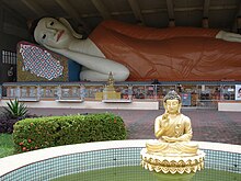
- Wat Machimmaram
- Wat Prachumthat Canaram
- Wat Phikulthong Vararam
- Wat Phothivihan
- Pantai Sri Tujuh
- Pantai Suri
- Pantai Geting
Transportation[]
Public transport[]
Tumpat is perhaps famous for being the northern terminal of the KTM East Coast Line, which began in Gemas in Negeri Sembilan. Bus options to Kota Bharu and Kuala Terengganu are available.
Car[]
The main federal highway serving Tumpat constituency is highway ![]() , going from downtown Kota Bharu, crossing the Kelantan River and terminating at Pengkalan Kubur. The main roads serving downtown Tumpat are Kelantan state routes
, going from downtown Kota Bharu, crossing the Kelantan River and terminating at Pengkalan Kubur. The main roads serving downtown Tumpat are Kelantan state routes ![]() and
and ![]() .
.
Climate[]
Tumpat has a tropical rainforest climate (Af) with moderate rainfall from February to April and heavy to very heavy rainfall in the remaining months.
| Climate data for Tumpat | |||||||||||||
|---|---|---|---|---|---|---|---|---|---|---|---|---|---|
| Month | Jan | Feb | Mar | Apr | May | Jun | Jul | Aug | Sep | Oct | Nov | Dec | Year |
| Average high °C (°F) | 29.2 (84.6) |
30.0 (86.0) |
31.3 (88.3) |
32.3 (90.1) |
32.5 (90.5) |
32.2 (90.0) |
31.7 (89.1) |
31.6 (88.9) |
31.5 (88.7) |
30.6 (87.1) |
29.3 (84.7) |
28.6 (83.5) |
30.9 (87.6) |
| Daily mean °C (°F) | 26.0 (78.8) |
26.2 (79.2) |
27.1 (80.8) |
27.9 (82.2) |
28.2 (82.8) |
27.9 (82.2) |
27.4 (81.3) |
27.4 (81.3) |
27.4 (81.3) |
26.9 (80.4) |
26.2 (79.2) |
25.7 (78.3) |
27.0 (80.6) |
| Average low °C (°F) | 22.6 (72.7) |
22.5 (72.5) |
22.9 (73.2) |
23.6 (74.5) |
24.0 (75.2) |
23.7 (74.7) |
23.2 (73.8) |
23.3 (73.9) |
23.3 (73.9) |
23.3 (73.9) |
23.2 (73.8) |
22.9 (73.2) |
23.2 (73.8) |
| Average rainfall mm (inches) | 172 (6.8) |
68 (2.7) |
80 (3.1) |
79 (3.1) |
130 (5.1) |
137 (5.4) |
129 (5.1) |
128 (5.0) |
177 (7.0) |
238 (9.4) |
553 (21.8) |
530 (20.9) |
2,421 (95.4) |
| Source: Climate-Data.org[4] | |||||||||||||
Notable people[]
- Ibrahim Ali
References[]
- ^ User, Super. "District Officers Of Tumpat". www.ptjt.kelantan.gov.my.
{{cite web}}:|last=has generic name (help) - ^ "Latar Belakang Tumpat". 26 June 2016.
- ^ a b "Population Distribution and Basic Demographic Characteristics, 2010" (PDF). Department of Statistics, Malaysia. Archived from the original (PDF) on 22 May 2014. Retrieved 19 April 2012.
- ^ "Climate: Tumpat". Climate-Data.org. Retrieved 28 October 2020.
| Wikimedia Commons has media related to Tumpat District. |
State of Kelantan | |||||
|---|---|---|---|---|---|
Capital: Kota Bharu, Royal town: Kubang Kerian | |||||
| |||||
| Society |
| ||||
| Administrative divisions |
| ||||
| |||||
This Kelantan location article is a stub. You can help Wikipedia by . |
- Populated places in Kelantan
- Districts of Kelantan
- Malaysia geography stubs