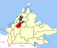
Tambunan District
Tambunan District
Daerah Tambunan | |
|---|---|
District | |
 Tambunan District Council office. | |
 Seal | |
 | |
| Coordinates: 5°40′26.47″N 116°21′53.58″E / 5.6740194°N 116.3648833°ECoordinates: 5°40′26.47″N 116°21′53.58″E / 5.6740194°N 116.3648833°E | |
| Country | |
| State | |
| Division | Interior |
| Capital | Tambunan |
| Government | |
| • District Officer | Thomas Logijin |
| Area | |
| • Total | 1,347 km2 (520 sq mi) |
| Population (2010) | |
| • Total | 35,667 |
| Website | www www |


The Tambunan District (Malay: Daerah Tambunan) is an administrative district in the Malaysian state of Sabah, part of the Interior Division which includes the districts of Beaufort, Keningau, Kuala Penyu, Nabawan, Sipitang, Tambunan and Tenom. The capital of the district is in Tambunan Town.
Etymology[]
The name of this area is taken from the word "Tamadon" and "Gombunan" which combined into "Tambunan".[1]
Demographics[]
According to the last census in 2010, the population of the district is estimated to be around 35,667 inhabitants.[2] The district of Tambunan is populated mainly by the indigenous group of Kadazan-Dusun (86%), while the rest of the population are Malay, Chinese and other indigenous groups.
Gallery[]

Nurul Iman Mosque
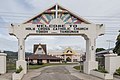
Holy Cross Catholic Church.
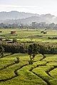
Tambunan paddy field.


See also[]
- Districts of Malaysia
References[]
- ^ "Laman Utama" (in Malay). Tambunan District Council. Archived from the original on 8 November 2017. Retrieved 8 November 2017.
- ^ "Population by ethnic group, Local Authority area and state, Malaysia" (PDF). Department of Statistics, Malaysia. 2010. Archived from the original (PDF) on 27 February 2012. Retrieved 5 November 2017.
Further reading[]
- Treacher, W. H (1891). "British Borneo: sketches of Brunai, Sarawak, Labuan, and North Borneo". University of California Libraries. Singapore, Govt. print. dept. p. 190.
- Rutter, Owen (1922). "British North Borneo - An Account of its History, Resources and Native Tribes". Cornell University Libraries. Constable & Company Ltd, London. p. 157.
- Tregonning, K. G. (1965). A History Of Modern Sabah (North Borneo 1881–1963). University of Malaya Press.
External links[]
![]() Media related to Tambunan District at Wikimedia Commons
Media related to Tambunan District at Wikimedia Commons
- (in Malay) Tambunan District Council
- (in Malay) Tambunan District Office
State of Sabah | |||||||||||||
|---|---|---|---|---|---|---|---|---|---|---|---|---|---|
Capital: Kota Kinabalu | |||||||||||||
| |||||||||||||
| Society |
| ||||||||||||
| Administrative divisions |
| ||||||||||||
| |||||||||||||
This Sabah location article is a stub. You can help Wikipedia by . |
- Districts of Sabah
- Sabah geography stubs