Hunker, Pennsylvania
Hunker, Pennsylvania | |
|---|---|
Borough | |
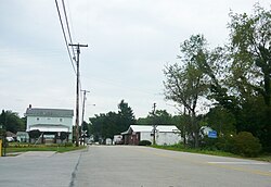 Bridge Street | |
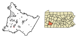 Location of Hunker in Westmoreland County, Pennsylvania. | |
 Hunker, Pennsylvania Location of Hunker in Westmoreland County, Pennsylvania. | |
| Coordinates: 40°12′16″N 79°36′58″W / 40.20444°N 79.61611°WCoordinates: 40°12′16″N 79°36′58″W / 40.20444°N 79.61611°W | |
| Country | United States |
| State | Pennsylvania |
| County | Westmoreland |
| Settled | 1903 |
| Incorporated | 1929 |
| Government | |
| • Type | Borough Council |
| Area | |
| • Total | 0.25 sq mi (0.66 km2) |
| • Land | 0.25 sq mi (0.66 km2) |
| • Water | 0.00 sq mi (0.00 km2) |
| Elevation | 994 ft (303 m) |
| Population (2010) | |
| • Total | 291 |
| • Estimate (2019)[2] | 272 |
| • Density | 1,075.10/sq mi (414.95/km2) |
| Time zone | UTC-5 (Eastern (EST)) |
| • Summer (DST) | UTC-4 (EDT) |
| Zip code | 15639 |
| FIPS code | 42-36288 |

Hunker is a borough in Westmoreland County, Pennsylvania, United States, and since 1950 has been part of the Pittsburgh metropolitan area. The population was 329 at the 2000 census.
Geography[]
Hunker is located at 40°12′16″N 79°36′58″W / 40.20444°N 79.61611°W (40.204462, -79.616218).[3]
According to the United States Census Bureau, the borough has a total area of 0.4 square miles (1.0 km2), all of it land.
Demographics[]
| Historical population | |||
|---|---|---|---|
| Census | Pop. | %± | |
| 1930 | 378 | — | |
| 1940 | 348 | −7.9% | |
| 1950 | 404 | 16.1% | |
| 1960 | 380 | −5.9% | |
| 1970 | 375 | −1.3% | |
| 1980 | 359 | −4.3% | |
| 1990 | 328 | −8.6% | |
| 2000 | 329 | 0.3% | |
| 2010 | 291 | −11.6% | |
| 2020 (est.) | 310 | [2] | 6.5% |
| Sources:[4][5][6] | |||
At the 2000 census there were 329 people, 136 households, and 102 families living in the borough. The population density was 886.8 people per square mile (343.3/km²). There were 138 housing units at an average density of 372.0 per square mile (144.0/km²). The racial makeup of the borough was 96.35% White, 0.61% African American, 0.30% Native American, 0.91% Asian, and 1.82% from two or more races.[5] Of the 136 households 25.0% had children under the age of 18 living with them, 67.6% were married couples living together, 6.6% had a female householder with no husband present, and 24.3% were non-families. 21.3% of households were one person and 11.8% were one person aged 65 or older. The average household size was 2.42 and the average family size was 2.83.
The age distribution was 17.0% under the age of 18, 6.4% from 18 to 24, 28.0% from 25 to 44, 33.4% from 45 to 64, and 15.2% 65 or older. The median age was 44 years. For every 100 females, there were 101.8 males. For every 100 females age 18 and over, there were 100.7 males.
The median household income was $40,313 and the median family income was $43,750. Males had a median income of $32,396 versus $15,833 for females. The per capita income for the borough was $22,045. About 7.6% of families and 6.1% of the population were below the poverty line, including 7.0% of those under age 18 and 12.5% of those age 65 or over.
Notable people[]
- Bob Garber, baseball player.
- Sarah Kozer, reality TV star.
References[]
- ^ "2019 U.S. Gazetteer Files". United States Census Bureau. Retrieved July 28, 2020.
- ^ a b "Population and Housing Unit Estimates". United States Census Bureau. May 24, 2020. Retrieved May 27, 2020.
- ^ "US Gazetteer files: 2010, 2000, and 1990". United States Census Bureau. 2011-02-12. Retrieved 2011-04-23.
- ^ "Census of Population and Housing". U.S. Census Bureau. Retrieved 11 December 2013.
- ^ a b "U.S. Census website". United States Census Bureau. Retrieved 2008-01-31.
- ^ "Incorporated Places and Minor Civil Divisions Datasets: Subcounty Resident Population Estimates: April 1, 2010 to July 1, 2012". Population Estimates. U.S. Census Bureau. Archived from the original on 11 June 2013. Retrieved 11 December 2013.

Greater Pittsburgh Region | ||
|---|---|---|
| Counties |
|  Map of the Pittsburgh Tri-State with green counties in the metropolitan area and yellow counties in the combined area |
| Major cities |
| |
| Cities and towns 15k–50k (in 2010) |
| |
| Airports | ||
| Topics |
| |
| ||
- Boroughs in Westmoreland County, Pennsylvania
- Pittsburgh metropolitan area
- 1929 establishments in Pennsylvania