Iceberg

An iceberg is a piece of freshwater ice more than 15 m long[1] that has broken off a glacier or an ice shelf and is floating freely in open (salt) water.[2][3] Smaller chunks of floating glacially-derived ice are called "growlers" or "bergy bits".[4][5] Both are generally spawned from disintegrating icebergs.[6] Iceberg size classes, as established by the International Ice Patrol, are summarized in Table 1. The 1912 loss of the RMS Titanic led to the formation of the International Ice Patrol in 1914. Much of an iceberg is below the surface, which led to the expression "tip of the iceberg" to illustrate a small part of a larger unseen issue. Icebergs are considered a serious maritime hazard.
Icebergs vary considerably in size and shape. Icebergs that calve from glaciers in Greenland, are often irregularly shaped while Antarctic ice shelves often produce large tabular (table top) icebergs. The largest iceberg currently floating in the ocean, named A-76, calved from the Ronne Ice Shelf into the Weddell Sea in Antarctica measuring 4320 km2.[7] The largest iceberg in recent history, named B-15, measured nearly 300 km x 40 km.[8] The B-15 iceberg calved from the Ross Ice Shelf in January 2000.[8] The largest iceberg on record was an Antarctic tabular iceberg of over 31,000 square kilometres (12,000 sq mi) [335 by 97 kilometres (208 by 60 mi)] sighted 240 kilometres (150 mi) west of Scott Island, in the South Pacific Ocean, by the USS Glacier on November 12, 1956. This iceberg was larger than Belgium.[9] Big icebergs are also often compared in size to the area of Manhattan.[10][11][12]
Etymology[]
The word iceberg is a partial loan translation from the Dutch word ijsberg, literally meaning ice mountain,[13] cognate to Danish isbjerg, German Eisberg, Low Saxon Iesbarg and Swedish isberg.
Overview[]
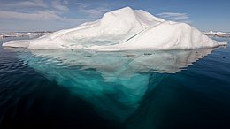
Typically about one-tenth of the volume of an iceberg is above water, which follows from Archimedes's Principle of buoyancy; the density of pure ice is about 920 kg/m3 (57 lb/cu ft), and that of seawater about 1,025 kg/m3 (64 lb/cu ft). The contour of the underwater portion can be difficult to judge by looking at the portion above the surface.
| Size class | Height (m) | Length (m |
|---|---|---|
| Growler | < 1 | < 5 |
| Bergy Bit | 1-5 | 5-15 |
| Small | 5-15 | 15-60 |
| Medium | 15-45 | 60-122 |
| Large | 45-75 | 122-213 |
| Very Large | >75 | >213 |
The largest icebergs recorded have been calved, or broken off, from the Ross Ice Shelf of Antarctica. Icebergs may reach a height of more than 100 metres (300 ft) above the sea surface, and have mass ranging from about 100,000 tonnes up to more than 10 million tonnes. Icebergs or pieces of floating ice smaller than 5 meters above the sea surface are classified as "bergy bits"; smaller than 1 meter—"growlers".[14] The largest known iceberg in the North Atlantic was 168 metres (551 ft) above sea level, reported by the USCG icebreaker Eastwind in 1958, making it the height of a 55-story building. These icebergs originate from the glaciers of western Greenland and may have interior temperatures of −15 to −20 °C (5 to −4 °F).[15]
Drift[]
A given iceberg's trajectory through the ocean can be modelled by integrating equation 1. Equation 1 assumes that an iceberg of mass m drifts with velocity v. The variables f, k, and F correspond to the Coriolis force, the vertical unit vector, and a given force. The subscripts a, w, r, s, and p correspond to the air drag, water drag, wave radiation force, sea ice drag, and the horizontal pressure gradient force.[16][17]
eq. (1).

Icebergs deteriorate through melting and fracturing, which changes the mass, m, as well as the surface area, volume, and stability of the iceberg.[17][18] Iceberg deterioration and drift, therefore, are interconnected iceberg thermodynamics and fracturing must be considered when modelling iceberg drift.[17]
Winds and currents may move icebergs close to coastlines, where they can become frozen into pack ice (one form of sea ice), or drift into shallow waters, where they can come into contact with the seabed, a phenomenon called seabed gouging.
Bubbles[]
Air trapped in snow forms bubbles as the snow is compressed to form firn and then glacial ice.[19] Icebergs can contain up to 10% air bubbles by volume.[19] These bubbles are released during melting, producing a fizzing sound that some may call "Bergie Seltzer". This sound results when the water-ice interface reaches compressed air bubbles trapped in the ice. As each bubble bursts it makes a "popping" sound[15] and the acoustic properties of these bubbles can be used to study iceberg melt.[20]
Stability[]
An iceberg may flip, or capsize, as it melts and breaks apart, changing the center of gravity. Capsizing can occur shortly after calving when the iceberg is young and establishing balance.[21] Icebergs are unpredictable and can capsize anytime and without warning. Large icebergs that break off from a glacier front and flip onto the glacier face can push the entire glacier backwards for a few minutes, producing earthquakes that give off as much energy as an atomic bomb.[22][23]
Color[]
Icebergs are generally white because they are covered in snow, but can be green, blue, yellow, black, striped, or even rainbow-colored.[24] Seawater, algae and lack of air bubbles in the ice can create diverse colors. Sediment can create the dirty black coloration present in some icebergs.[25]

Shape[]

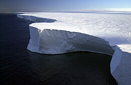
In addition to size classification (Table 1), icebergs can be classified on the basis of their shapes. The two basic types of iceberg forms are tabular and non-tabular. Tabular icebergs have steep sides and a flat top, much like a plateau, with a length-to-height ratio of more than 5:1.[26]
This type of iceberg, also known as an ice island,[27] can be quite large, as in the case of Pobeda Ice Island. Antarctic icebergs formed by breaking off from an ice shelf, such as the Ross Ice Shelf or Filchner-Ronne Ice Shelf, are typically tabular. The largest icebergs in the world are formed this way.
Non-tabular icebergs have different shapes and include:[28]
- Dome: An iceberg with a rounded top.
- Pinnacle: An iceberg with one or more spires.
- Wedge: An iceberg with a steep edge on one side and a slope on the opposite side.
- Dry-Dock: An iceberg that has eroded to form a slot or channel.
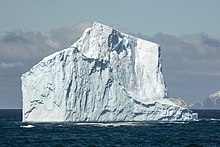
- Blocky: An iceberg with steep, vertical sides and a flat top. It differs from tabular icebergs in that its aspect ratio, the ratio between its width and height, is small, more like that of a block than a flat sheet.
Monitoring and control[]
History[]
Prior to 1914 there was no system in place to track icebergs to guard ships against collisions.[citation needed] despite fatal sinkings of ships by icebergs. In 1907, SS Kronprinz Wilhelm, a German liner, rammed an iceberg and suffered a crushed bow, but was still able to complete her voyage. The advent of steel ship construction led designers to declare their ships "unsinkable".
The April 1912 sinking of the Titanic, which killed 1,496 of its 2,223 passengers and crew, discredited this claim. For the remainder of the ice season of that year, the United States Navy patrolled the waters and monitored ice movements. In November 1913, the International Conference on the Safety of Life at Sea met in London to devise a more permanent system of observing icebergs. Within three months the participating maritime nations had formed the International Ice Patrol (IIP). The goal of the IIP was to collect data on meteorology and oceanography to measure currents, ice-flow, ocean temperature, and salinity levels. They monitored iceberg dangers near the Grand Banks of Newfoundland and provided the "limits of all known ice" in that vicinity to the maritime community. The IIP published their first records in 1921, which allowed for a year-by-year comparison of iceberg movement.
Technological development[]

Aerial surveillance of the seas in the early 1930s allowed for the development of charter systems that could accurately detail the ocean currents and iceberg locations. In 1945, experiments tested the effectiveness of radar in detecting icebergs. A decade later, oceanographic monitoring outposts were established for the purpose of collecting data; these outposts continue to serve in environmental study. A computer was first installed on a ship for the purpose of oceanographic monitoring in 1964, which allowed for a faster evaluation of data. By the 1970s, ice-breaking ships were equipped with automatic transmissions of satellite photographs of ice in Antarctica. Systems for optical satellites had been developed but were still limited by weather conditions. In the 1980s, drifting buoys were used in Antarctic waters for oceanographic and climate research. They are equipped with sensors that measure ocean temperature and currents.

Side looking airborne radar (SLAR) made it possible to acquire images regardless of weather conditions. On November 4, 1995, Canada launched RADARSAT-1. Developed by the Canadian Space Agency, it provides images of Earth for scientific and commercial purposes. This system was the first to use synthetic aperture radar (SAR), which sends microwave energy to the ocean surface and records the reflections to track icebergs. The European Space Agency launched ENVISAT (an observation satellite that orbits the Earth's poles)[29] on March 1, 2002. ENVISAT employs advanced synthetic aperture radar (ASAR) technology, which can detect changes in surface height accurately. The Canadian Space Agency launched RADARSAT-2 in December 2007, which uses SAR and multi-polarization modes and follows the same orbit path as RADARSAT-1.[30]
Modern monitoring[]
Iceberg concentrations and size distributions are monitored worldwide by the U.S. National Ice Center (NIC), established in 1995, which produces analyses and forecasts of Arctic, Antarctic, Great Lakes and Chesapeake Bay ice conditions. More than 95% of the data used in its sea ice analyses are derived from the remote sensors on polar-orbiting satellites that survey these remote regions of the Earth.

The NIC is the only organization that names and tracks all Antarctic Icebergs. It assigns each iceberg larger than 10 nautical miles (19 km) along at least one axis a name composed of a letter indicating its point of origin and a running number. The letters used are as follows:[31]
- A – longitude 0° to 90° W (Bellingshausen Sea, Weddell Sea)
- B – longitude 90° W to 180° (Amundsen Sea, Eastern Ross Sea)
- C – longitude 90° E to 180° (Western Ross Sea, Wilkes Land)
- D – longitude 0° to 90° E (Amery Ice Shelf, Eastern Weddell Sea)
The Danish Meteorological Institute monitors iceberg populations around Greenland using data collected by the synthetic aperture radar (SAR) on the Sentinel-1 satellites.
Iceberg management[]
In Labrador and Newfoundland, iceberg management plans have been developed to protect offshore installations from impacts with icebergs.[32]
Commercial use[]
In the late 2010s, a business from the UAE wanted to tow an iceberg from Antarctica to the Middle East, but the plan failed as the estimated cost of $200 million was too high.[33] In 2019, a German company, Polewater,announced plans to tow Antarctic icebergs to places like South Africa.[34][35]
Companies have used iceberg water in products such as bottled water, fizzy ice cubes and alcoholic drinks.[34] For example, Iceberg Beer by Quidi Vidi Brewing Company is made from icebergs found around St. John's, Newfoundland.[36] Although annual iceberg supply in Newfoundland and Labrador exceeds total freshwater consumption of the United States, in 2016, the province introduced a tax on iceberg harvesting, and imposed a limit on how much fresh water can be exported yearly.[34]
Oceanography and ecology[]
The freshwater injected into the ocean by melting icebergs can change the density of the seawater in the vicinity of the iceberg.[37][38] Fresh melt water released at depth is lighter, and therefore more buoyant, than the surrounding seawater causing it to rise towards the surface.[37][38] Icebergs can also act as floating breakwaters, impacting ocean waves.[39]
Icebergs contain variable concentrations of nutrients and minerals that are released into the ocean during melting.[40][41] Iceberg-derived nutrients, particularly the iron contained in sediments, can fuel blooms of phytoplankton.[40][42] Samples collected from icebergs in Antarctica, Patagonia, Greenland, Svalbard, and Iceland, however, show that iron concentrations vary significantly,[41] complicating efforts to generalize the impacts of icebergs on marine ecosystems.
Recent large icebergs[]

Iceberg B15 calved from the Ross Ice Shelf in 2000 and initially had an area of 11,000 square kilometres (4,200 sq mi). It broke apart in November 2002. The largest remaining piece of it, Iceberg B-15A, with an area of 3,000 square kilometres (1,200 sq mi), was still the largest iceberg on Earth until it ran aground and split into several pieces October 27, 2005, an event that was observed by seismographs both on the iceberg and across Antarctica.[43] It has been hypothesized that this breakup may also have been abetted by ocean swell generated by an Alaskan storm 6 days earlier and 13,500 kilometres (8,400 mi) away.[44][45]
- 1987, Iceberg B-9, 5,390 km2 (2,080 sq mi)
- 1998, Iceberg A-38, about 6,900 km2 (2,700 sq mi)[46]
- 1999, Iceberg B-17B 140 km2 (54 sq mi), shipping alert issued December 2009.[47]
- 2000, Iceberg B-15 11,000 km2 (4,200 sq mi)
- 2002, Iceberg C-19, 5,500 km2 (2,100 sq mi)
- 2002, Iceberg B-22, 5,490 km2 (2,120 sq mi)
- 2003 broke off, Iceberg B-15A, 3,100 km2 (1,200 sq mi)
- 2006, Iceberg D-16, 310 km2 (120 sq mi)
- 2010, Ice sheet, 260 km2 (100 sq mi), broken off of Petermann Glacier in northern Greenland on August 5, 2010, considered to be the largest Arctic iceberg since 1962.[48] About a month later, this iceberg split into two pieces upon crashing into Joe Island in the Nares Strait next to Greenland.[49] In June 2011, large fragments of the Petermann Ice Islands were observed off the Labrador coast.[50]
- 2014, Iceberg B-31, 615 km2 (237 sq mi), 2014[51]
- 2017, Iceberg A-68, (Larsen C) 5,800 km2 (2,200 sq mi)[52]
- 2018, Iceberg B-46, 225 km2 (87 sq mi)[53]
- 2019, Iceberg D-28, 1,636 km2 (632 sq mi)[54]
- 2021, Iceberg A-74 from the Brunt Ice Shelf, 1,270 km2 (490 sq mi)[55][56]
- 2021, Iceberg A-76 from the Ronne Ice Shelf, 4,320 km2 (1,670 sq mi)[57]
See also[]

- List of recorded icebergs by area
- Drift ice station
- Ice calving
- Ice drift
- Polar ice cap
- Polar ice pack (disambiguation)
- Polynya
- Sea ice
- Seabed gouging by ice
- Shelf ice
References[]
- ^ Jump up to: a b "Iceberg Formation: International Ice Patrol" (PDF). International Ice Patrol.
- ^ "Definitions of the word 'Iceberg'". Retrieved 2006-12-20.
- ^ "Common Misconceptions about Icebergs and Glaciers". Ohio State University.
Icebergs float in salt water, but they are formed from freshwater glacial ice.
- ^ "bergy bit". National Snow and Ice Data Center. Retrieved 2019-12-01.
- ^ "Bergy Bits and Growlers". www.athropolis.com. Retrieved 2019-12-01.
- ^ "Bergy bit | National Snow and Ice Data Center".
- ^ "Meet the world's largest iceberg". European Space Agency. 19 May 2021.
- ^ Jump up to: a b Remy, J.-P.; Becquevort, S.; Haskell, T.G.; Tison, J.-L. (December 2008). "Impact of the B-15 iceberg "stranding event" on the physical and biological properties of sea ice in McMurdo Sound, Ross Sea, Antarctica". Antarctic Science. 20 (6): 593–604. doi:10.1017/S0954102008001284. ISSN 0954-1020.
- ^ "Antarctica shed a 208-mile-long berg in 1956". Polar Times. 43. 2005-01-20. p. 18.
- ^ Zamira Rahim (September 14, 2020). "A chunk of ice twice the size of Manhattan has broken off Greenland in the last two years". CNN. Retrieved September 23, 2020.
- ^ Maddie Stone (February 21, 2019). "An Iceberg 30 Times the Size of Manhattan Is About to Break Off Antarctica". Gizmodo. Archived from the original on October 27, 2019. Retrieved September 23, 2020.
- ^ Lorraine Chow (November 1, 2018). "An iceberg 5 times bigger than Manhattan just broke off from Antarctica". Business Insider. Archived from the original on October 27, 2019. Retrieved September 23, 2020.
- ^ "Iceberg". Online Etymology Dictionary. Retrieved 2006-03-26.
- ^ "Iceberg Classification Systems".
- ^ Jump up to: a b "Facts on Icebergs". Canadian Geographic. 2006. Archived from the original on 2006-03-31.
- ^ Carlson, Daniel F.; Boone, Wieter; Meire, Lorenz; Abermann, Jakob; Rysgaard, Søren (2017-08-28). "Bergy Bit and Melt Water Trajectories in Godthåbsfjord (SW Greenland) Observed by the Expendable Ice Tracker". Frontiers in Marine Science. 4: 276. doi:10.3389/fmars.2017.00276. ISSN 2296-7745.
- ^ Jump up to: a b c Bigg, Grant R.; Wadley, Martin R.; Stevens, David P.; Johnson, John A. (October 1997). "Modelling the dynamics and thermodynamics of icebergs". Cold Regions Science and Technology. 26 (2): 113–135. doi:10.1016/S0165-232X(97)00012-8.
- ^ Crawford, Anna; Mueller, Derek; Joyal, Gabriel (2018-04-08). "Surveying Drifting Icebergs and Ice Islands: Deterioration Detection and Mass Estimation with Aerial Photogrammetry and Laser Scanning". Remote Sensing. 10 (4): 575. doi:10.3390/rs10040575. ISSN 2072-4292.
- ^ Jump up to: a b Scholander, P. F.; Nutt, D. C. (1960). "Bubble Pressure in Greenland Icebergs". Journal of Glaciology. 3 (28): 671–678. doi:10.3189/S0022143000017950. ISSN 0022-1430.
- ^ Glowacki, Oskar; Deane, Grant B.; Moskalik, Mateusz (2018-05-16). "The Intensity, Directionality, and Statistics of Underwater Noise From Melting Icebergs". Geophysical Research Letters. 45 (9): 4105–4113. doi:10.1029/2018GL077632. ISSN 0094-8276.
- ^ MacAyeal, Douglas R.; Abbot, Dorian S.; Sergienko, Olga V. (2011). "Iceberg-capsize tsunamigenesis". Annals of Glaciology. 52 (58): 51–56. doi:10.3189/172756411797252103. ISSN 0260-3055.
- ^ Stephen Ornes (April 3, 2012). "Flipping Icebergs". ScienceNews for Students. Retrieved June 9, 2019.
- ^ Nell Greenfieldboyce (June 25, 2015). "Study Reveals What Happens During A 'Glacial Earthquake'". npr.org. Retrieved March 9, 2021.
- ^ Katherine Wright (January 5, 2018). "Icebergs Can Be Green, Black, Striped, Even Rainbow". Scientific American. Retrieved June 9, 2019.
- ^ Roach, Lettie. "Image of the Week - Super-cool colours of icebergs". EGU Blogs. European Geosciences Union. Retrieved 6 November 2020.
- ^ "Sizes and Shapes of Icebergs" (PDF). International Ice Patrol. Retrieved 2006-12-20.
- ^ Weeks, W.F. (2010), On Sea Ice, University of Alaska Press, p. 399
- ^ Holly Gordon (2006). "Iceberg Physiology". Canadian Geographic. Archived from the original on 2006-03-31.
- ^ "Envisat". European Space Agency. Retrieved 2011-03-09.
- ^ Ainslie MacLellan (2006). "Tracking Monsters". Canadian Geographic. Archived from the original on 2006-10-31.
- ^ "New Iceberg Breaks off Ronne Ice Shelf in Antarctica". NOAA. 15 October 1998. Retrieved 2011-03-09.
- ^ Ice-management, Newfoundland Labrador offshore-industry
- ^ "Why a Middle Eastern business thirsty for water can't just tow an iceberg from Antarctica". 14 August 2019.
- ^ Jump up to: a b c Matthew H. Birkhold (October 31, 2019). "$166 Water Could Dictate International Iceberg Law". The Atlantic. Retrieved September 8, 2021.
- ^ "Home Page". Polewater. Retrieved September 8, 2021.
- ^ Emma Jacobs (February 29, 2012). "Newfoundland Gives Whole New Meaning To Ice Cold Beer". Morning Edition. Retrieved September 8, 2021.
- ^ Jump up to: a b Yankovsky, Alexander E.; Yashayaev, Igor (September 2014). "Surface buoyant plumes from melting icebergs in the Labrador Sea". Deep Sea Research Part I: Oceanographic Research Papers. 91: 1–9. doi:10.1016/j.dsr.2014.05.014.
- ^ Jump up to: a b Stephenson, Gordon R.; Sprintall, Janet; Gille, Sarah T.; Vernet, Maria; Helly, John J.; Kaufmann, Ronald S. (June 2011). "Subsurface melting of a free-floating Antarctic iceberg". Deep Sea Research Part II: Topical Studies in Oceanography. 58 (11–12): 1336–1345. doi:10.1016/j.dsr2.2010.11.009.
- ^ Ardhuin, Fabrice; Tournadre, Jean; Queffeulou, Pierre; Girard-Ardhuin, Fanny; Collard, Fabrice (January 2011). "Observation and parameterization of small icebergs: Drifting breakwaters in the southern ocean". Ocean Modelling. 39 (3–4): 405–410. doi:10.1016/j.ocemod.2011.03.004.
- ^ Jump up to: a b Duprat, Luis P. A. M.; Bigg, Grant R.; Wilton, David J. (March 2016). "Enhanced Southern Ocean marine productivity due to fertilization by giant icebergs". Nature Geoscience. 9 (3): 219–221. doi:10.1038/ngeo2633. ISSN 1752-0894.
- ^ Jump up to: a b Hopwood, Mark J.; Carroll, Dustin; Höfer, Juan; Achterberg, Eric P.; Meire, Lorenz; Le Moigne, Frédéric A. C.; Bach, Lennart T.; Eich, Charlotte; Sutherland, David A.; González, Humberto E. (December 2019). "Highly variable iron content modulates iceberg-ocean fertilisation and potential carbon export". Nature Communications. 10 (1): 5261. doi:10.1038/s41467-019-13231-0. ISSN 2041-1723. PMC 6868171. PMID 31748607.
- ^ Wu, Shuang-Ye; Hou, Shugui (2017-03-17). "Impact of icebergs on net primary productivity in the Southern Ocean". The Cryosphere. 11 (2): 707–722. doi:10.5194/tc-11-707-2017. ISSN 1994-0424.
- ^ Martin, Seelye; Drucker, Robert; Aster, Richard; Davey, Fred; Okal, Emile; Scambos, Ted; MacAyeal, Douglas (2010). "Kinematic and seismic analysis of giant tabular iceberg breakup at Cape Adare, Antarctica". Journal of Geophysical Research. 115 (B6): B06311. Bibcode:2010JGRB..115.6311M. doi:10.1029/2009JB006700. S2CID 16420188.
- ^ "Alaskan storm cracks giant iceberg to pieces in faraway Antarctica".
- ^ MacAyeal, Douglas R; Okal, Emile A; Aster, Richard C; Bassis, Jeremy N; Brunt, Kelly M; Cathles, L. Mac; Drucker, Robert; Fricker, Helen A; Kim, Young-Jin; Martin, Seelye; Okal, Marianne H; Sergienko, Olga V; Sponsler, Mark P; Thom, Jonathan E (2006). "Transoceanic wave propagation links iceberg calving margins of Antarctica with storms in tropics and Northern Hemisphere". Geophysical Research Letters. 33 (17): L17502. Bibcode:2006GeoRL..3317502M. doi:10.1029/2006GL027235.
- ^ "Iceberg A-38B off South Georgia". Visible Earth. Archived from the original on 2008-10-05. Retrieved 2011-03-09.
- ^ "Shipping alert issued over giant iceberg". Associated Press. December 11, 2009.
- ^ "Huge ice sheet breaks from Greenland glacier". BBC. 2010-08-07. Retrieved 2011-03-09.
- ^ "Massive Iceberg Crashes into Island, Splits in Two". Archived from the original on 2011-03-10.
- ^ "Massive ice island heading for southern Labrador". CBC News. 2011-06-23.
- ^ Brad Lendon, CNN (22 April 2014). "Iceberg is twice the size of Atlanta - CNN.com". CNN.
- ^ "Iceberg four times the size of London breaks off from Antarctica ice shelf". The Telegraph. Retrieved 14 July 2017.
- ^ "Pine Island Glacier Quickly Drops Another Iceberg". Nasa Earth Observatory. NASA. 8 November 2018. Retrieved 12 November 2018.
- ^ Cox, Lisa (1 September 2019). "Giant iceberg breaks off east Antarctica". The Guardian. Retrieved 1 September 2019.
- ^ "Brunt Ice Shelf in Antarctica calves". British Antarctic Survey. 26 February 2021.
- ^ LT Falon M. Essary (1 March 2021). "Iceberg A-74 Calves from the Brunt Ice Shelf in the Weddell Sea". U.S. National Ice Center.
- ^ "World's largest iceberg breaks off from Antarctica". CNN.com. 19 May 2021.
External links[]
| Wikimedia Commons has media related to: Iceberg (category) |
- Iceberg Finder Service for east coast of Canada
- Icebergs of The Arctic and Antarctic
 Works related to Iceberg at Wikisource
| hide | |||||
|---|---|---|---|---|---|
| Crystalline types | |||||
| Formations and phenomena |
| ||||
| Ice-related activities |
| ||||
| Constructions | |||||
| Work | |||||
| Other uses | |||||
| Ice ages | |||||
| |||||
| show Authority control |
|---|
- Bodies of ice
- Icebergs
- Ice in transportation
- Oceanographical terminology