Jennings, Missouri
Jennings, Missouri | |
|---|---|
City | |
| City of Jennings | |
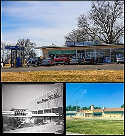 Top: Business in Jennings; bottom left: River Roads Mall (demolished); bottom right: Church in Jennings | |
 Flag | |
 Location of Jennings, Missouri | |
| Coordinates: 38°43′16″N 90°15′41″W / 38.72111°N 90.26139°WCoordinates: 38°43′16″N 90°15′41″W / 38.72111°N 90.26139°W | |
| Country | United States |
| State | Missouri |
| County | St. Louis |
| Area | |
| • Total | 3.73 sq mi (9.67 km2) |
| • Land | 3.73 sq mi (9.67 km2) |
| • Water | 0.00 sq mi (0.00 km2) |
| Elevation | 518 ft (158 m) |
| Population | |
| • Total | 14,712 |
| • Estimate (2019)[5] | 14,575 |
| • Density | 3,903.32/sq mi (1,507.04/km2) |
| Time zone | UTC-6 (Central (CST)) |
| • Summer (DST) | UTC-5 (CDT) |
| ZIP code | 63136 |
| Area code(s) | 314 |
| FIPS code | 29-37178[3] |
| GNIS feature ID | 0756226[4] |
| Website | Official website |

Jennings is a city in St. Louis County, Missouri, United States. The population was 14,712 at the 2010 census.
Geography[]
Jennings is located at 38°43′16″N 90°15′41″W / 38.72111°N 90.26139°W (38.721100, -90.261428).[6]
According to the United States Census Bureau, the city has a total area of 3.70 square miles (9.58 km2), all land.[7]
Demographics[]
| Historical population | |||
|---|---|---|---|
| Census | Pop. | %± | |
| 1950 | 15,282 | — | |
| 1960 | 19,965 | 30.6% | |
| 1970 | 19,379 | −2.9% | |
| 1980 | 16,934 | −12.6% | |
| 1990 | 15,905 | −6.1% | |
| 2000 | 15,469 | −2.7% | |
| 2010 | 14,712 | −4.9% | |
| 2019 (est.) | 14,575 | [5] | −0.9% |
| U.S. Decennial Census[8] | |||
2010 census[]
At the 2010 census there were 14,712 people, 5,847 households and 3,782 families living in the city. The population density was 3,976.2 per square mile (1,535.2/km2). There were 6,937 housing units at an average density of 1,874.9 per square mile (723.9/km2). The racial makeup of the city was 89.8% African American, 8.5% White, 0.1% Native American, 0.2% Asian, 0.2% from other races, and 1.1% from two or more races. Hispanic or Latino of any race were 0.6%.[2]
Of the 5,847 households, 36.4% had children under the age of 18 living with them, 22.4% were married couples living together, 36.0% had a female householder with no husband present, 6.3% had a male householder with no wife present, and 35.3% were non-families. 31.2% of households were one person and 10.4% were one person aged 65 or older. The average household size was 2.51 and the average family size was 3.13.
The median age was 35.2 years. 27% of residents were under the age of 18; 10.3% were between the ages of 18 and 24; 24.3% were from 25 to 44; 27.7% were from 45 to 64; and 10.7% were 65 or older. The gender makeup of the city was 44.5% male and 55.5% female.
2000 census[]
At the 2000 census there were 15,469 people, 6,174 households and 4,081 families living in the city. The population density was 4,193.3 per square mile (1,619.0/km2). There were 6,798 housing units at an average density of 1,842.8 per square mile (711.5/km2). The racial make-up was 19.32% White, 78.58% African American, 0.10% Native American, 0.38% Asian, 0.03% Pacific Islander, 0.19% from other races, and 1.40% from two or more races. Hispanic or Latino of any race were 0.73%.[3]
Of the 6,174 households, 35.3% had children under the age of 18 living with them, 29.2% were married couples living together, 31.5% had a female householder with no husband present, and 33.9% were non-families. 30.4% of households were one person and 11.6% were one person aged 65 or older. The average household size was 2.50 and the average family size was 3.12.
The age distribution was 30.4% under the age of 18, 9.0% from 18 to 24, 29.2% from 25 to 44, 20.3% from 45 to 64, and 11.1% 65 or older. The median age was 33 years. For every 100 females, there were 79.5 males. For every 100 females age 18 and over, there were 72.2 males.
The median household income was $29,196 and the median family income was $33,761. Males had a median income of $28,697 and females $25,013. The per capita income was $15,820. About 16.0% of families and 19.0% of the population were below the poverty line, including 28.3% of those under age 18 and 14.6% of those age 65 or over.
Public safety[]
The City of Jennings contracts with the St. Louis County Police Department to provide professional police services to the city.
The City of Jennings Police Department was disbanded by the city in 2011 due to corruption within the department, including cases of missing money.[9]
Jennings has its own Fire Department that protects the city with 16 full-time firefighters. Jennings FD regularly backs up Northeast Ambulance & Fire Protection District on mutual-aid calls.
References[]
- ^ "2019 U.S. Gazetteer Files". United States Census Bureau. Retrieved July 26, 2020.
- ^ Jump up to: a b "U.S. Census website". United States Census Bureau. Retrieved July 8, 2012.
- ^ Jump up to: a b "U.S. Census website". United States Census Bureau. Retrieved January 31, 2008.
- ^ "US Board on Geographic Names". United States Geological Survey. October 25, 2007. Retrieved 2008-01-31.
- ^ Jump up to: a b "Population and Housing Unit Estimates". United States Census Bureau. May 24, 2020. Retrieved May 27, 2020.
- ^ "US Gazetteer files: 2010, 2000, and 1990". United States Census Bureau. February 12, 2011. Retrieved April 23, 2011.
- ^ "US Gazetteer files 2010". United States Census Bureau. Archived from the original on July 2, 2012. Retrieved July 8, 2012.
- ^ "Census of Population and Housing". Census.gov. Retrieved June 4, 2015.
- ^ "Jennings Police Department Dissolves". KMOV. March 12, 2011. Archived from the original on August 20, 2014. Retrieved August 27, 2014.
- "Darren Wilson's First Job Was on a Troubled Police Force Disbanded by Authorities". Washington Post. August 23, 2014. Retrieved August 27, 2014.
External links[]
| show Municipalities and communities of St. Louis County, Missouri, United States |
|---|


| show Authority control |
|---|
- Cities in St. Louis County, Missouri
- Cities in Missouri