Hanley Hills, Missouri
Hanley Hills, Missouri | |
|---|---|
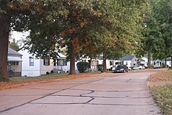 Houses in Hanley Hills, October 2016 | |
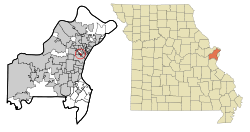 Location of Hanley Hills, Missouri | |
| Coordinates: 38°41′11″N 90°19′35″W / 38.68639°N 90.32639°WCoordinates: 38°41′11″N 90°19′35″W / 38.68639°N 90.32639°W | |
| Country | United States |
| State | Missouri |
| County | St. Louis |
| Area | |
| • Total | 0.36 sq mi (0.94 km2) |
| • Land | 0.36 sq mi (0.94 km2) |
| • Water | 0.00 sq mi (0.00 km2) |
| Elevation | 545 ft (166 m) |
| Population | |
| • Total | 2,101 |
| • Estimate (2019)[4] | 2,101 |
| • Density | 5,771.98/sq mi (2,226.48/km2) |
| Time zone | UTC-6 (Central (CST)) |
| • Summer (DST) | UTC-5 (CDT) |
| FIPS code | 29-30196[5] |
| GNIS feature ID | 0756148[2] |
| Website | www |

Hanley Hills is a village in St. Louis County, Missouri, United States. The population was 2,101 at the 2010 census.[6]
Geography[]
Hanley Hills is located at 38°41′11″N 90°19′35″W / 38.68639°N 90.32639°W (38.686251, -90.326371).[7]
According to the United States Census Bureau, the village has a total area of 0.36 square miles (0.93 km2), all land.[8]
Demographics[]
| Historical population | |||
|---|---|---|---|
| Census | Pop. | %± | |
| 1950 | 2,219 | — | |
| 1960 | 3,308 | 49.1% | |
| 1970 | 2,801 | −15.3% | |
| 1980 | 2,439 | −12.9% | |
| 1990 | 2,325 | −4.7% | |
| 2000 | 2,124 | −8.6% | |
| 2010 | 2,101 | −1.1% | |
| 2019 (est.) | 2,101 | [4] | 0.0% |
| U.S. Decennial Census[9] | |||
2010 census[]
As of the census[3] of 2010, there were 2,101 people, 867 households, and 571 families living in the village. The population density was 5,836.1 inhabitants per square mile (2,253.3/km2). There were 940 housing units at an average density of 2,611.1 per square mile (1,008.2/km2). The racial makeup of the village was 12.0% White, 85.3% African American, 0.1% Native American, 0.4% Asian, 0.3% from other races, and 1.9% from two or more races. Hispanic or Latino of any race were 1.3% of the population.
There were 867 households, of which 34.1% had children under the age of 18 living with them, 23.3% were married couples living together, 36.4% had a female householder with no husband present, 6.1% had a male householder with no wife present, and 34.1% were non-families. 29.3% of all households were made up of individuals, and 7.7% had someone living alone who was 65 years of age or older. The average household size was 2.42 and the average family size was 2.95.
The median age in the village was 38.1 years. 25.1% of residents were under the age of 18; 8.9% were between the ages of 18 and 24; 25.8% were from 25 to 44; 30.9% were from 45 to 64; and 9.2% were 65 years of age or older. The gender makeup of the village was 44.6% male and 55.4% female.
2000 census[]
As of the census[5] of 2000, there were 2,124 people, 864 households, and 582 families living in the village. The population density was 5,721.9 people per square mile (2,216.4/km2). There were 939 housing units at an average density of 2,529.6 per square mile (979.9/km2). The racial makeup of the village was 21.61% White, 76.74% African American, 0.05% Native American, 0.14% Asian, 0.19% from other races, and 1.27% from two or more races. Hispanic or Latino of any race were 0.47% of the population.
There were 864 households, out of which 32.5% had children under the age of 18 living with them, 31.1% were married couples living together, 30.7% had a female householder with no husband present, and 32.6% were non-families. 28.8% of all households were made up of individuals, and 9.0% had someone living alone who was 65 years of age or older. The average household size was 2.46 and the average family size was 3.01.
In the village, the population was spread out, with 27.0% under the age of 18, 9.1% from 18 to 24, 30.0% from 25 to 44, 24.1% from 45 to 64, and 9.7% who were 65 years of age or older. The median age was 36 years. For every 100 females, there were 77.1 males. For every 100 females age 18 and over, there were 70.1 males.
The median income for a household in the village was $33,802, and the median income for a family was $37,368. Males had a median income of $30,833 versus $25,969 for females. The per capita income for the village was $15,906. About 6.3% of families and 9.3% of the population were below the poverty line, including 11.8% of those under age 18 and 7.7% of those age 65 or over.
References[]
- ^ "2019 U.S. Gazetteer Files". United States Census Bureau. Retrieved July 26, 2020.
- ^ a b U.S. Geological Survey Geographic Names Information System: Hanley Hills, Missouri
- ^ a b "U.S. Census website". United States Census Bureau. Retrieved 2012-07-08.
- ^ a b "Population and Housing Unit Estimates". United States Census Bureau. May 24, 2020. Retrieved May 27, 2020.
- ^ a b "U.S. Census website". United States Census Bureau. Retrieved 2008-01-31.
- ^ "Race, Hispanic or Latino, Age, and Housing Occupancy: 2010 Census Redistricting Data (Public Law 94-171) Summary File (QT-PL), Hanley Hills village, Missouri". United States Census Bureau. Retrieved October 25, 2011.
- ^ "US Gazetteer files: 2010, 2000, and 1990". United States Census Bureau. 2011-02-12. Retrieved 2011-04-23.
- ^ "US Gazetteer files 2010". United States Census Bureau. Retrieved 2012-07-08.
- ^ "Census of Population and Housing". Census.gov. Retrieved June 4, 2015.

- Villages in St. Louis County, Missouri
- Villages in Missouri