Joes, Colorado
Joes, Colorado | |
|---|---|
 Joes, looking east on U.S. Route 36. | |
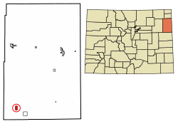 Location of the Joes CDP in Yuma County, Colorado. | |
 Joes Location of the Joes CDP in the United States. | |
| Coordinates: 39°39′21″N 102°40′43″W / 39.6559429°N 102.6784948°WCoordinates: 39°39′21″N 102°40′43″W / 39.6559429°N 102.6784948°W[2] | |
| Country | |
| State | |
| County | Yuma County |
| Government | |
| • Type | unincorporated town |
| Area | |
| • Total | 2.088 sq mi (5.408 km2) |
| • Land | 2.085 sq mi (5.401 km2) |
| • Water | 0.003 sq mi (0.007 km2) |
| Elevation | 4,275 ft (1,303 m) |
| Population (2010) | |
| • Total | 80 |
| • Density | 38/sq mi (15/km2) |
| Time zone | UTC-7 (MST) |
| • Summer (DST) | UTC-6 (MDT) |
| ZIP Code[3] | 80822 |
| Area code(s) | 970 |
| GNIS feature[1] | Joes CDP |

Joes is an unincorporated town, a post office, and a census-designated place (CDP) located in and governed by Yuma County, Colorado, United States. The Joes post office has the ZIP Code 80822.[3] At the United States Census 2010, the population of the Joes CDP was 80, while the population of the 80822 ZIP Code Tabulation Area was 260 including adjacent areas.[4]
History[]
The Joes post office has been in operation since 1912.[5] The community was named for the fact a share of the first settlers were named Joe.[6]
Geography[]
The Joes CDP has an area of 1,336 acres (5.408 km2), including 1.7 acres (0.007 km2) of water.[2] Joes is home to Liberty High School.
Demographics[]
The United States Census Bureau initially defined the Joes CDP for the United States Census 2010.
| Year | Pop. | ±% |
|---|---|---|
| 2010 | 80 | — |
| 2020 | — | |
| Source: United States Census Bureau | ||
See also[]
- Outline of Colorado
- State of Colorado
- Colorado cities and towns
- Colorado census designated places
- Colorado counties
- Colorado cities and towns
References[]
- ^ Jump up to: a b c "U.S. Board on Geographic Names: Domestic Names". United States Geological Survey. Retrieved December 27, 2020.
- ^ Jump up to: a b c "State of Colorado Census Designated Places - BAS20 - Data as of January 1, 2020". United States Census Bureau. Retrieved December 27, 2020.
- ^ Jump up to: a b "Look Up a ZIP Code". United States Postal Service. Retrieved December 27, 2020.
- ^ "2010: DEC Summary File 1". United States Census Bureau. Retrieved December 27, 2020.
- ^ "Post offices". Jim Forte Postal History. Retrieved 28 June 2016.
- ^ Dawson, John Frank. Place names in Colorado: why 700 communities were so named, 150 of Spanish or Indian origin. Denver, CO: The J. Frank Dawson Publishing Co. p. 28. Archived from the original on 2016-11-08.
- Propst, Nell B. (1988). The Boys From Joes: A Colorado Basketball Legend. Boulder, CO: Pruett Publishing. ISBN 0-87108-932-7
External links[]
Joes, Coloradoat Wikipedia's sister projects
 Definitions from Wiktionary
 Media from Wikimedia Commons
 News from Wikinews
 Quotations from Wikiquote
 Texts from Wikisource
 Textbooks from Wikibooks
 Resources from Wikiversity
| hide Municipalities and communities of Yuma County, Colorado, United States | ||
|---|---|---|
| Cities |  | |
| Town | ||
| CDPs | ||
| Unincorporated community | ||
| Ghost towns | ||
| ||
| Authority control |
|
|---|
Categories:
- Census-designated places in Yuma County, Colorado
- Census-designated places in Colorado