Johnson Square (Savannah, Georgia)
 The Nathanael Greene Monument stands in the center of the square | |||
| Namesake | Robert Johnson | ||
|---|---|---|---|
| Maintained by | City of Savannah | ||
| Location | Savannah, Georgia, U.S. | ||
| Coordinates | 32°04′48″N 81°05′29″W / 32.0799°N 81.0915°WCoordinates: 32°04′48″N 81°05′29″W / 32.0799°N 81.0915°W | ||
| North | Bull Street | ||
| East | East St. Julian Street | ||
| South | Bull Street | ||
| West | West St. Julian Street | ||
| Construction | |||
| Completion | 1733 | ||

Johnson Square is one of the 22 squares of Savannah, Georgia, United States. Located in the first row of the city's five rows of squares, it was the first of the squares to be laid out, in 1733, and remains the largest of the 22. It is east of Ellis Square, west of Reynolds Square and north of Wright Square. Situated on Bull Street and St. Julian Street, it is named for Robert Johnson, colonial governor of South Carolina and a friend of General Oglethorpe.[1][2] The oldest building on the square is 26 East Bryan Street, which dates to 1824.[3]
Interred under his monument in the square is Revolutionary War hero General Nathanael Greene, the namesake of nearby Greene Square. Greene died in 1786 and was buried in Savannah's Colonial Park Cemetery. His son was buried beside him after drowning in the Savannah River in 1793. Following vandalism of the cemetery by occupying Union forces during the Civil War the location of Greene's burial was lost. After the remains were re-identified Greene and his son were moved to Johnson Square. An obelisk in the center of the square now serves as a memorial to General Greene. The cornerstone of the monument was laid by the Marquis de La Fayette in 1825. At that time the obelisk did not yet commemorate any specific individual or event. In fact, due to financial restrictions the unmarked obelisk served for several years as a joint monument to both Greene and Casimir Pulaski. Inscriptions honoring Greene were added in 1886, but the Greenes’ physical remains did not arrive until 1901, following their "rediscovery."[4][2][5]
Johnson Square contains two fountains, as well as a sundial dedicated to Colonel William Bull, the namesake of Savannah's Bull Street. Bull was a South Carolinian who assisted Oglethorpe with the establishment of Savannah and, as a surveyor, laid out the original street grid. The sundial has four panels, one on each side of its square granite base. The dial itself is bronze, set atop a marble shaft. One of the base panels reproduces a 1734 map of Savannah.[2]
Another landmark of Johnson Square is the Johnson Square Business Center. This building, formerly known as the Savannah Bank Building, was the city's first "skyscraper", built in 1911. Johnson Square is known as the financial district, or banking square, and many of the City's financial services companies are located here. These companies include the Savannah Bancorp, Savannah Bank, Coastal Bank Headquarters, Bank of America branch, SunTrust branch, TitleMax Corporate Headquarters, and a Regions Bank building.
Christ Church Episcopal occupies the southeastern trust lot of the square at 28 Bull Street. Although it did not have a stand-alone structure during Georgia's first generation, Christ Church was the mother church of the State of Georgia.
Markers and structures[]

Historical marker in the square

Sundial
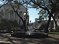
One of the square's two fountains, with Christ Church in the background


Constituent buildings[]
Each building below is in one of the eight blocks around the square composed of four residential "tything" blocks and four civic ("trust") blocks, now known as the Oglethorpe Plan. They are listed with construction years where known.
- Northwestern residential/tything block
- 10 Whitaker Street (1878)[3]
- 18 West Bryan Street (1912)[3]
- John L. Hardee Property, 22–24 West Bryan Street (1878)[3]
- Southwestern trust/civic block
- United Community Bank, 27 Bull Street (1912)[3]
- Northeastern residential/tything block
- Johnson Square Business Center, 2 East Bryan Street (1911)[3] – former Savannah Bank and Trust Building
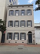
- Ann Hamilton House, 24–26 East Bryan Street (1824)[3] – oldest building on the square
- 30–32 East Bryan Street (1916)[3]
- 9 Drayton Street (1853)[6]
- Citizens Bank Building, 15 Drayton Street (1895)[3] – now Propes Hall, part of SCAD
- Northeastern trust/civic block
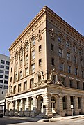
- Bank of America, 22 Bull Street (1907)[3] – former Citizens and Southern Bank
- Southeastern trust/civic block
- Christ Church Episcopal Church, 28 Bull Street (1838/1897)[3]
- Southeastern residential/tything block
- The Manger Building, 7 East Congress Street (1913)[3] – formerly the Hotel Savannah
Gallery[]

The former Savannah Bank and Trust Building, at 2 East Bryan Street
Ann Hamilton House, 24–26 East Bryan Street

The Citizens and Southern Bank (now Bank of America), 22 Bull Street

Christ Church Episcopal, 28 Bull Street

The Manger Building (the former Hotel Savannah), at 7 East Congress Street
SCAD's Propes Hall, at 15 Drayton Street in the northeastern tything block

Another view of 15 Drayton Street

John L. Hardee Property, 22–24 East Bryan Street


References[]
- ^ Savannah Scene magazine, May–June 2007, pp 10–11, accessed June 16, 2007.
- ^ a b c City of Savannah's monuments page This page links directly to numerous short entries, many accompanied by photographs, discussing a variety of monuments, memorials, etc., in the squares and elsewhere. Accessed June 16, 2007.
- ^ a b c d e f g h i j k l Historic Building Map: Savannah Historic District – Historic Preservation Department of the Chatham County-Savannah Metropolitan Planning Commission (November 17, 2011), p. 9
- ^ Tour Guide Manual for licensed tour guides in the City of Savannah, accessed June 16, 2007.
- ^ Mulberry Grove Plantation, accessed June 16, 2007.
- ^ Savannah, Immortal City: Volume One of the Civil War Savannah Series, Barry Sheehy, Cindy Wallace, Vaughnette Goode-Walker (2011) ISBN 9781934572702
- Johnson Square, Savannah
- 1733 establishments in the Thirteen Colonies