Pulaski Square (Savannah, Georgia)
 The square in 2017 | |||
| Namesake | Casimir Pulaski | ||
|---|---|---|---|
| Maintained by | City of Savannah | ||
| Location | Savannah, Georgia, U.S. | ||
| Coordinates | 32°04′27″N 81°05′46″W / 32.0741°N 81.0962°WCoordinates: 32°04′27″N 81°05′46″W / 32.0741°N 81.0962°W | ||
| North | Barnard Street | ||
| East | West Macon Street | ||
| South | Barnard Street | ||
| West | West Macon Street | ||
| Construction | |||
| Completion | 1837 | ||

Pulaski Square is one of the 22 squares of Savannah, Georgia, United States. It is located in the fourth row of the city's five rows of squares, on Barnard Street and West Macon Street, and was laid out in 1837. It is south of Orleans Square, west of Madison Square and north of Chatham Square. It is known for its live oaks. The oldest buildings on the square are 126 West Harris Street and 218 West Harris Street, which date to 1839.[1]
The square is named for General Casimir Pulaski, a Polish-born Revolutionary War hero who died of wounds received in the siege of Savannah (1779).[2] It is one of the few squares without a monument; General Pulaski's statue (and, likely, his remains) is in nearby Monterey Square.[3]
Prior to the birth of the historical preservation movement and the restoration of much of Savannah's downtown, Pulaski sheltered a sizeable homeless population and was one of several squares that had been paved to allow traffic to drive straight through its center.[4]
The square is one of the few to have a parking lot occupy one of its blocks (in this case the northeastern trust lot).
Dedication[]

The square is named for Polish nobleman General Casimir Pulaski (1745–1779)

Constituent buildings[]
Each building below is in one of the eight blocks around the square composed of four residential "tything" blocks and four civic ("trust") blocks, now known as the Oglethorpe Plan. They are listed with construction years where known.
- Northwestern residential/tything lot
- Georgia LaRoche Duplex, 208 West Harris Street (1855)[1]
- Georgia LaRoche Duplex, 210 West Harris Street (1848)[1]
- Isaac LaRoche Duplex, 212–214 West Harris Street (1868)[1]
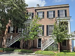
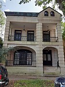
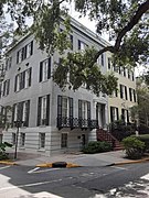
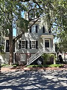
- Bernard Constantine House, 218 West Harris Street (1839)[1] – joint-oldest building on the square
- Northwestern civic/trust lot
- Bernard Constantine Property (1), 321 Barnard Street (1845)[1]
- Southwestern civic/trust lot
- 331 Barnard Street (1844)[1]
- Southwestern residential/tything lot
- Northeastern residential/tything lot
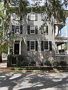
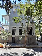
- Theodosius Bartow House, 126 West Harris Street (1839)[1] – third storey added later; joint-oldest building on the square
- John Gammel Duplex, 118–120 West Harris Street (1884)[1]
- The Battersby Tenements, 108–110 West Harris Street (1871)[1]
- 106 West Harris Street (1847)[1]
- Southeastern civic/trust lot
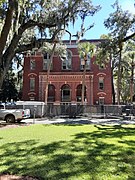
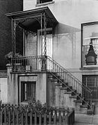
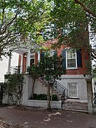
- JEA Building, 328 Barnard Street (1914)[1] – also known as Pulaski House
- Southeastern residential/tything lot
Gallery[]
JEA Building, 328 Barnard Street

Bernard Constantine House, 218 West Harris Street

Isaac LaRoche Duplex, 212-214 West Harris Street
Georgia LaRoche Duplex, 208–210 West Harris Street
Theodosius Bartow House, 126 West Harris Street

John Gammel Duplex, 118–120 West Harris Street
The Battersby Tenements, 108–110 West Harris Street
106 West Harris Street
109 West Charlton Street
Hill Gordy House, 111 West Charlton Street

George Walker House, 117 West Charlton Street
William Adams House, 123 West Charlton Street
Celia Solomons Duplex, 201–203 West Charlton Street
Moses Cohen House, 215 West Charlton Street, built by John Sturdevant
Bernard Constantine Property (1), 321 Barnard Street


References[]
- ^ a b c d e f g h i j k l m n o p q r Historic Building Map: Savannah Historic District – Historic Preservation Department of the Chatham County-Savannah Metropolitan Planning Commission (November 17, 2011), p. 46
- ^ SavannahBest.com's ‘’Squares of Savannah’‘, accessed June 16, 2007
- ^ Savannah Scene magazine, May–June 2007, pp 10–11, accessed June 16, 2007.
- ^ Chan Sieg (1984). The squares: an introduction to Savannah. Virginia Beach: Donning.
This Chatham County, Georgia state location article is a stub. You can help Wikipedia by . |
- Squares of Savannah, Georgia
- 1837 establishments in Georgia (U.S. state)
- Coastal Georgia geography stubs