Greene Square (Savannah, Georgia)
 Greene Square, laid out in 1799, with the John Dorsett House in view in the background | |||
| Namesake | Nathanael Greene | ||
|---|---|---|---|
| Maintained by | City of Savannah | ||
| Location | Savannah, Georgia, U.S. | ||
| Coordinates | 32°04′35″N 81°05′10″W / 32.0763°N 81.0861°WCoordinates: 32°04′35″N 81°05′10″W / 32.0763°N 81.0861°W | ||
| North | Houston Street | ||
| East | East President Street | ||
| South | Houston Street | ||
| West | East President Street | ||
| Construction | |||
| Completion | 1799 | ||

Greene Square is one of the 22 squares of Savannah, Georgia, United States. It is the easternmost square in the second row of the city's five rows of squares. The square is located on Houston Street and East President Street, and is south of Washington Square, east of Columbia Square and north of Crawford Square. The oldest buildings on the square are at 510 East York Street, 509 East President Street and 503 East President Street (Thomas Williams House), which are believed to have been built at the same time as the square itself (1799).[1]
The square is named for Revolutionary War hero General Nathanael Greene, an aide to George Washington.[2] A native of Rhode Island, Greene commanded southern forces during the Revolution, and after the war settled at Mulberry Grove, an estate fourteen miles (23 km) above Savannah. Greene, along with his son, is actually buried in Savannah's Johnson Square.
134 Houston Street, in the square's southeastern tything block, dates to the late 1800s.[1] Between 1899 and the mid-1900s it was the home of the Kate Baldwin Free Kindergarten.[3]
Greene Square was once the center of Savannah's African-American community.[4] In the northwestern trust lot is Second African Baptist Church, the site where Union Army General William Tecumseh Sherman famously announced Special Field Orders 15, better known as "40 acres and a mule".
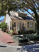
Green Palm Inn (two seamen's cottages, ca. 1897) is on the square.[1]
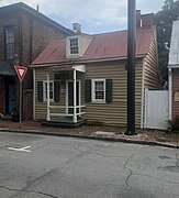
The John Dorsett House, in the northwestern tything, is the smallest free-standing house in the city, hence its nickname Tiny House. It was moved here from 422 Hull Street.[5]
In 1967 Savannah landscape architect Clermont Huger Lee and Mills B. Lane planned and initiated a project to replace the cistern that caved-in, design and install shoring, close the fire lane, and install new walks, benches, lighting and planting.[6]
Dedication[]
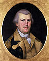
The square is named for Revolutionary War hero Nathanael Greene (1742–1786)

Constituent buildings[]
Each building below is in one of the eight blocks around the square composed of four residential "tything" blocks and four civic ("trust") blocks, now known as the Oglethorpe Plan. They are listed with construction years where known.
- Northwestern tything/residential block
- Anderson Row, 502–512 East State Street (1890)[1]
- 514 East State Street (1900)[1]
- 516 East State Street (1900)[1]
- 520 East State Street (1900)[1]
- Henry Cunningham House, 117–119 Houston Street (1810)[1] – built for Henry Cunningham, Free Man of Color. By 1812, it was the site of the Savannah Female Asylum
- James King House, 113 Houston Street (1854)[1]
- 51 East Broughton Lane
- Northwestern trust/civic block
- Southwestern trust/civic block
- 131 Houston Street (1807)[1]
- Jeremiah Murphy House, 129 Houston Street (1904)[1]
- 509 East President Street (1799–1808)[1] – joint-oldest building on the square
- 505 East President Street (1853)[1]
- Thomas Williams House, 503 East President Street (1799–1808)[1] – joint-oldest building on the square
- Southwestern tything/residential block
- 506–508 East York Street (1902)[1]
- 507 East York Street (1839)[1]
- 509 East York Street (1839)[1]
- 510 East York Street (1799–1808)[1] – joint-oldest building on the square
- 511 East York Street (1855)[1]
- Catherine Devaux House, 513 East York Street (1853)[1]
- 515 East York Street (1853)[1]
- Susannah Clarke Cottage, 517 East York Street (1801–1808)[1]
- Edward White Cottage, 519 East York Street (1812)[1]
- Margaret McDonald House, 521 East York Street (1883)[1]
- 140 Price Street (1828)[1]
- 515 East York Lane[1]
- 508 East York Lane (1828)[1] – the rear of 140 Price Street
- Northeastern tything/residential block
- 532–534 East State Street (1897)[1]
- John Dorsett House, 536 East State Street (1845)[1][8] – moved from 422 Hull Street to Greene Square in the mid-20th century
- 538 East State Street (1818)[1]
- 542 East State Street (1818)[1]
- 548 East State Street (1860)[1]
- Joseph Burke House, 550 East State Street (1854)[1]
- 112 East Broughton Lane (1900)[1]
- 111 East Broad Street (1841)[1]
- 115 East Broad Street (1914)[1]
- Northeastern trust/civic block
- 124 Houston Street (1897)[1]
- 546–548 East President Street (1897)[1] – formerly two Victorian cottages,[9] has been occupied by the Green Palm Inn since 1998. At that time the properties were combined into one.[9][10] The properties were built for sea captains Samuel House and N. B. Sison.[9]
- 125 East Broad Street (1914)[1]
- Southeastern trust/civic block
- Southeastern tything/residential block
- Kate Baldwin Free Kindergarten, 134–142 Houston Street (late 1800s)[1]
- 545 East York Street[1]
Gallery[]

Catherine Devaux House, 513 East York Street

Susannah Clarke Cottage, 517 East York Street
Edward White Cottage, 519 East York Street

Margaret McDonald House, 521 East York Street

140 Price Street

James King House, 113 Houston Street

Henry Cunningham House, 117–119 Houston Street

124 Houston Street, a relatively late addition to the square, as it looked during World War II
Jeremiah Murphy House, 129 Houston Street
131 Houston Street

Thomas Williams House, 503 East President Street

Green Palm Inn, 548 East President Street

111 East Broad Street

Anderson Row, 502–512 East State Street

Joseph Burke House, 550 East State Street


References[]
- ^ a b c d e f g h i j k l m n o p q r s t u v w x y z aa ab ac ad ae af ag ah ai aj ak al am an ao ap aq ar Historic Building Map: Savannah Historic District – Historic Preservation Department of the Chatham County-Savannah Metropolitan Planning Commission (November 17, 2011), p. 31
- ^ SavannahBest.com's ‘’Squares of Savannah’‘, accessed June 16, 2007
- ^ History of the Kindergarten Movement, Association for Childhood Education (U.S.) Committee of nineteen (1935), p. 20
- ^ Tour Guide Manual for licensed tour guides in the City of Savannah, accessed June 16, 2007.
- ^ "Dix Fletcher" – The Savannah Biographies, Jane Schulze (July 29, 1981), p. 4
- ^ Dolder, Ced (Spring 2014). "Clermont Lee, (1914-2006) Pioneering Savannah Landscape Architect" (PDF). Magnolia – Publication of the Southern Garden History Society. XXVII (2): 4. Retrieved 16 February 2020.
- ^ "Historic Second African Baptist Church" – The Savannah Tribune
- ^ The National Trust Guide to Savannah – Roulhac Toledano (1997)
- ^ a b c About the Inn - Green Palm Inn's official website
- ^ Green Palm Inn official website
- Greene Square, Savannah
- 1799 establishments in Georgia (U.S. state)