Lafayette Square (Savannah, Georgia)
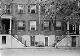
 Flannery O'Connor's childhood home stands in the southeastern tything lot of the square | |||
| Namesake | Gilbert du Motier, Marquis de Lafayette | ||
|---|---|---|---|
| Maintained by | City of Savannah | ||
| Location | Savannah, Georgia, U.S. | ||
| Coordinates | 32°04′23″N 81°05′30″W / 32.0730°N 81.0917°WCoordinates: 32°04′23″N 81°05′30″W / 32.0730°N 81.0917°W | ||
| North | Abercorn Street | ||
| East | East Macon Street | ||
| South | Abercorn Street | ||
| West | East Macon Street | ||
| Construction | |||
| Completion | 1837 | ||

Lafayette Square is one of the 22 squares of Savannah, Georgia, United States. It is located in the fourth row of the city's five rows of squares, on Abercorn Street and East Macon Street, and was laid out in 1837. It is south of Colonial Park Cemetery, west of Troup Square, north of Calhoun Square and east of Madison Square. The square is named for Gilbert du Motier, Marquis de Lafayette, the French hero of the American Revolution who visited Savannah in 1825. The oldest building on the square is the Fitzgerald Pelot House, at 221 East Charlton Street, which dates to 1840.[1]
The square contains a fountain commemorating the 250th anniversary of the founding of the Georgia colony, donated by the Colonial Dames of Georgia in 1984, as well as cobblestone sidewalks.[2][3][4]
Adjacent to the square is the Roman Catholic Cathedral Basilica of St. John the Baptist. Given this proximity, Lafayette Square features prominently in Savannah's massive Saint Patrick's Day celebrations. Water in the fountain is dyed green for the occasion.[5]
In this area is the museum known as the Flannery O'Connor Childhood Home, which is open to the public.
Marist Place, the former Marist School for Boys, stands in the southwest tything of the square.
Dedication[]

The square is named for Gilbert du Motier, Marquis de Lafayette (1757–1834), French aristocrat and military officer who fought in the American Revolutionary War

Markers and structures[]

The square's fountain
A video of the fountain


Constituent buildings[]
Each building below is in one of the eight blocks around the square composed of four residential "tything" blocks and four civic ("trust") blocks, now known as the Oglethorpe Plan. They are listed with construction years where known.
- Northwestern residential/tything lot
- 104 East Harris Street (1875)[1]
- Centurian House, 106 East Harris Street (1903)[1]
- 118 and 124 East Harris Street (1852)[1]
- 319 Abercorn Street (1888)[1]
- Southwestern civic/trust lot
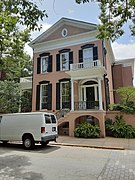
- Andrew Low House, 329 Abercorn Street (1849)[1] – part of the Juliette Gordon Low Historic District; oldest building on the square
- Andrew Low Carriage House, 330 Drayton Street (1873)[1] – part of the Juliette Gordon Low Historic District
- Southwestern residential/tything lot
- Marist Place, 123 East Charlton Street (c. 1919)
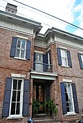
- Battersby–Hartridge–Anderson House, 119 East Charlton Street (1852)[1]
- Northeastern residential/tything lot
- Cathedral Basilica of St. John the Baptist, 222 East Harris Street (1876) – spires added in 1896
- Southeastern civic/trust lot
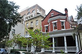
- Hamilton–Turner Inn, 330 Abercorn Street (1873)[1]
- Southeastern residential/tything lot
- Fitzgerald Pelot Duplex, 221–223 East Charlton Street (1854–1855)[1]
- Catherine McMahon House, 211 East Charlton Street (1853)[1]
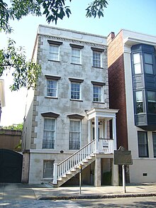
- Flannery O'Connor Childhood Home, 207 East Charlton Street (1856)[1]
- John B. Gallie House, 201–203 East Charlton Street (1858)[1]
- 340 Abercorn Street (1903)
Gallery[]

Cathedral Basilica of St. John the Baptist, 222 East Harris Street

Hamilton-Turner Inn, 330 Abercorn Street

Battersby–Hartridge–Anderson House, 119 East Charlton Street

Marist Place, 123 East Charlton Street
Catherine McMahon House, 211 East Charlton Street

Fitzgerald Pelot Duplex, 221–223 East Charlton Street

Andrew Low House, 329 Abercorn Street
319 Abercorn Street

340 Abercorn Street

104 East Harris Street
Centurian House, 106 East Harris Street
118 and 124 East Harris Street

John B. Gallie House, 201–203 East Charlton Street


References[]
- ^ a b c d e f g h i j k l m Historic Building Map: Savannah Historic District – Historic Preservation Department of the Chatham County-Savannah Metropolitan Planning Commission (November 17, 2011), p. 51
- ^ See Savannah by T.D. Conner (2001), accessed June 14, 2007
- ^ Savannah Scene magazine, May–June 2007, pp 10–11, accessed June 16, 2007.
- ^ City of Savannah's monuments page This page links directly to numerous short entries, many accompanied by photographs, discussing a variety of monuments, memorials, etc., in the squares and elsewhere. Accessed June 16, 2007.
- ^ Chan Sieg (1984). The squares: an introduction to Savannah. Virginia Beach: Donning.
- Lafayette Square, Savannah
- 1837 establishments in Georgia (U.S. state)