Kārsava
This article does not cite any sources. (January 2012) |
Kārsava | |
|---|---|
Town | |
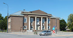 Cultural centre in Kārsava | |
 Coat of arms | |
 Kārsava Location in Latvia | |
| Coordinates: 56°47′N 27°40′E / 56.783°N 27.667°ECoordinates: 56°47′N 27°40′E / 56.783°N 27.667°E | |
| Country | |
| District | Ludza District |
| Town rights | 1928 |
| Area | |
| • Total | 4.07 km2 (1.57 sq mi) |
| • Land | 4.02 km2 (1.55 sq mi) |
| • Water | 0.05 km2 (0.02 sq mi) |
| Population (2021)[2] | |
| • Total | 1,923 |
| • Density | 470/km2 (1,200/sq mi) |
| Time zone | UTC+2 (EET) |
| • Summer (DST) | UTC+3 (EEST) |
| Postal code | LV-5717 |
| Calling code | +371 657 |
| Website | http://www.karsava.lv/ |

Kārsava (![]() pronunciation (help·info); German: Karsau, Russian: Корсовка, Korsovka, Yiddish: קאָרסאָװקע, Korsovke) is a town in Latvia. Kārsava is located in the historical region of Latgale near the border of Russia.
pronunciation (help·info); German: Karsau, Russian: Корсовка, Korsovka, Yiddish: קאָרסאָװקע, Korsovke) is a town in Latvia. Kārsava is located in the historical region of Latgale near the border of Russia.
The ancient Baltic tribe Latgalians inhabited the territory of Kārsava since the 8th century. There are several hillforts near town.
In 1763 a Catholic church was built in Kārsava. The town was located near the Rēzekne-Ostrov postal road and it saw rapid development when the St. Petersburg-Vilnius railway line was constructed nearby and the town became a trading centre.
On the eve of World War II, the population of Kārsava was approximately 2,000 to 2,500, 90% of whom were Jewish. The vast majority of them were murdered during the Holocaust.
See also[]
- List of cities in Latvia
References[]
- ^ https://data.stat.gov.lv/pxweb/lv/OSP_PUB/START__ENV__DR__DRT/DRT010/; Central Statistical Bureau of Latvia; retrieved: 25 February 2021.
- ^ https://data.stat.gov.lv/pxweb/lv/OSP_PUB/START__POP__IR__IRS/IRD060/; Central Statistical Bureau of Latvia; retrieved: 15 June 2021.
This Latgale location article is a stub. You can help Wikipedia by . |
- Towns in Latvia
- Populated places established in 1928
- Kārsava Municipality
- Latgale geography stubs