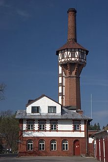
Strenči
Strenči | |
|---|---|
Town | |
 | |
 Coat of arms | |
 Strenči Location in Latvia | |
| Coordinates: 57°37′N 25°41′E / 57.617°N 25.683°ECoordinates: 57°37′N 25°41′E / 57.617°N 25.683°E | |
| Country | |
| Municipality | Strenči Municipality |
| Town rights | 1928 |
| Government | |
| • Mayor | Velga Graumane |
| Area | |
| • Total | 5.72 km2 (2.21 sq mi) |
| • Land | 5.43 km2 (2.10 sq mi) |
| • Water | 0.29 km2 (0.11 sq mi) |
| Elevation | 45 m (148 ft) |
| Population (2021)[2] | |
| • Total | 988 |
| • Density | 170/km2 (450/sq mi) |
| Time zone | UTC+2 (EET) |
| • Summer (DST) | UTC+3 (EEST) |
| Postal code | LV-4730 |
| Calling code | +371 647 |
| Website | http://www.strenci.lv/ |
Strenči (pronounced [ˈstrentʃi] (![]() listen); German: Stackeln) is a town in Latvia. The capital of Strenči Municipality, it is about 130 km (80 mi) northeast of Riga, about 20 km (12 mi) northeast of Valmiera and about 30 km (18 mi) southwest of Valka.
listen); German: Stackeln) is a town in Latvia. The capital of Strenči Municipality, it is about 130 km (80 mi) northeast of Riga, about 20 km (12 mi) northeast of Valmiera and about 30 km (18 mi) southwest of Valka.
Strenči is known as the raftsmen capital of Latvia, due to the town's location on the Gauja river and historical role in timber rafting.
Strenči is bordered by North Vidzeme Biosphere Reserve.
Twin towns — sister cities[]
Strenči is twinned with:[3]
See also[]
- List of cities in Latvia
References[]
- ^ https://data.stat.gov.lv/pxweb/lv/OSP_PUB/START__ENV__DR__DRT/DRT010/; Central Statistical Bureau of Latvia; retrieved: 25 February 2021.
- ^ https://data.stat.gov.lv/pxweb/lv/OSP_PUB/START__POP__IR__IRS/IRD060/; Central Statistical Bureau of Latvia; retrieved: 15 June 2021.
- ^ "Sadraudzības pilsētas". strencunovads.lv (in Latvian). Strenči. Retrieved 2019-08-31.
| Wikivoyage has a travel guide for Strenči. |
Categories:
- Towns in Latvia
- 1928 establishments in Latvia
- Populated places established in 1928
- Strenči Municipality
- Vidzeme geography stubs
