Kalandsvatnet
From Wikipedia, the free encyclopedia
| Kalandsvatnet | |
|---|---|
 | |
 Kalandsvatnet Location of the lake  Kalandsvatnet Kalandsvatnet (Norway) | |
| Location | Bergen, Vestland |
| Coordinates |  60°16′20″N 5°23′55″E / 60.2721°N 5.3986°E / 60.2721; 5.3986Coordinates: 60°16′20″N 5°23′55″E / 60.2721°N 5.3986°E / 60.2721; 5.3986 60°16′20″N 5°23′55″E / 60.2721°N 5.3986°E / 60.2721; 5.3986Coordinates: 60°16′20″N 5°23′55″E / 60.2721°N 5.3986°E / 60.2721; 5.3986 |
| Basin countries | Norway |
| Max. length | 3 kilometres (1.9 mi) |
| Max. width | 2.66 kilometres (1.65 mi) |
| Surface area | 3.5 km2 (1.4 sq mi) |
| Shore length1 | 12.39 kilometres (7.70 mi) |
| Surface elevation | 53 metres (174 ft) |
| References | NVE |
| 1 Shore length is not a well-defined measure. | |
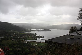
Kalandsvatnet is the largest lake in the municipality of Bergen in Vestland county, Norway. The 3.5-square-kilometre (1.4 sq mi) lake is located in the borough of Fana, just east of the village of Fanahammeren. The European route E39 highway runs along the northeastern shore of the lake, about 12 kilometres (7.5 mi) south of the city centre of Bergen.[1]
See also[]
- List of lakes in Norway
References[]
- ^ "Kalandsvatnet" (in Norwegian). Bergens byarkiv. Retrieved 2014-09-17.
This article related to Bergen, Norway is a stub. You can help Wikipedia by . |
- v
- t
Retrieved from ""
Categories:
- Geography of Bergen
- Lakes of Vestland
- Bergen stubs
Hidden categories:
- CS1 Norwegian-language sources (no)
- Coordinates on Wikidata
- Articles using infobox body of water without alt
- Articles using infobox body of water without pushpin map alt
- Articles using infobox body of water without image bathymetry
- AC with 0 elements
- All stub articles