Mjøsa
This article needs additional citations for verification. (July 2012) |
| Mjøsa | |
|---|---|
 View northwards from Minnesund, Eidsvoll | |
 Mjøsa | |
| Location | Innlandet, Viken |
| Coordinates | 60°40′N 11°00′E / 60.667°N 11.000°ECoordinates: 60°40′N 11°00′E / 60.667°N 11.000°E |
| Primary inflows | Gudbrandsdalslågen |
| Primary outflows | Vorma |
| Basin countries | Norway |
| Max. length | 117 km (73 mi) |
| Max. width | 15 km (9.3 mi) |
| Surface area | 362 km2 (140 sq mi)[1] |
| Average depth | 155 m (509 ft)[1] (other source 153 m[2]) |
| Max. depth | 449 m (1,473 ft)[1][2] (other sources give 468 m) |
| Water volume | 56.0 km3 (45,400,000 acre⋅ft)[1] |
| Surface elevation | 121 m (397 ft)[1] (other sources give 123 m[2]) |
| Islands | Helgøya |
| Settlements | Hamar, Gjøvik, Lillehammer |
| References | [1] |


Mjøsa is Norway's largest lake, as well as one of the deepest lakes in Norway and in Europe. It is the fourth-deepest lake in Norway. It is located in the southern part of Norway, about 100 km north of Oslo. Its main tributary is Gudbrandsdalslågen in the north; the only distributary is Vorma in the south. Inflows would theoretically need 5.6 years to fill the lake. With an average depth of 153 meters, most of the lake's volume is under sea level. Average outflow (measured 1931–1982) is 316 m3/s or 9959 million m3 per year.[2] Mjøsa contains about 56 km3 of water compared to 15 km3 of Røssvatnet, the second largest lake by volume in Norway.
Thomas Robert Malthus travelled through Norway in 1799 and his diaries from the trip includes a description of Mjøsa. Malthus wrote that Mjøsa appears as both lake and river because the shores are defined by mountains and where the valley becomes wider the water fills the space. Below Minde (Minnesund) the lake only appears like a river and is called Vorma on the map, according to Malthus.[3]
Location[]

From its southernmost point at Minnesund in Eidsvoll to its northernmost point in Lillehammer it is 117 km long. At its widest, near Hamar, it is 15 km wide. It is 365 km² in area and its volume is estimated at 56 km³; normally its surface is 123 metres above sea level, and its greatest depth is 468 metres. Its total coastline is estimated at 273 km, of which 30% is built up. Dams built on the distributary of Vorma in 1858, 1911, 1947, and 1965 raised the level by approximately 3.6 metres in total. In the last 200 years, 20 floods have been registered that added 7 metres to the level of Mjøsa. Several of these floods inundated the city of Hamar.
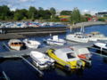
The cities of Hamar, Gjøvik, and Lillehammer were founded along the shores of the lake. Before the construction of railways past the lake, it was an important transport route. Today, aside from minor leisure boating and the steamship Skibladner, there is no water traffic on the lake. Most of its shores are dominated by rolling agricultural areas, among them some of the most fertile grainlands in Norway. The main train line, the Dovre Line between Oslo and Trondheim, goes along its eastern shore, making stops in Hamar and Lillehammer. From the south European route E6 runs along the eastern shore of the lake until the Mjøsa Bridge connects Moelv on the east with Biri on the west.

Mjøskastellet[]
The largest and only island is Helgøya. Except for Helgøya, Mjøsa only contains small islets. The most interesting of these is Steinsholmen, which holds the ruins of Mjøskastellet, a medieval citadel dating from the 13th century. Established by King Haakon IV of Norway, it was first mentioned in a letter dated 1234. Peter Andreas Blix documented the site and made drawings in 1897. Hedmark Museum has a future archaeological plan for the site.[4][5]
Fish[]
Lake Mjøsa has 20 species of fish. Among the most common are pike, European perch, common roach, greyling, and the hundertrout, a brown trout which can reach a weight more than 20 kg. Another common species is the European smelt, which is the most important baitfish for the predators. Historically, the most economically significant species is the lågsild (European cisco).
Source of drinking water[]
Hamar / Ottestad – Hias IKS responsibility for the waterworks and waste-water treatment plants in Hamar, Stange og Løten kommune (municipalities). https://www.hias.no/ .
Lillehammer – Operates waterworks at Korgen. Contracts have been signed for a new flood-proof waterworks to be built in Hovemoen.
Gjøvik – WWTP run from Rambekk Renseanlegg
Østre-Toten – Kapp / Skreia
Brumunddal – Biri / Moelv (New)
The name[]
The name (Norse Mjǫrs, Proto-Norse *Merso) must be very old. The meaning is, maybe, 'the bright/shiny one'. (If *mer- is related to the English word mere 'clear, bright', and -so is a suffix.)
The lake seen from the harbor in Hamar

The landmark Geiteryggen looking south from Hamar
Mjøsa from Hamar

Steamboat Skibladner on the lake of Mjøsa

Steinholmen on lake Mjøsa


Events[]
From 1932 to 1934, ice racing was held on the lake's northern reaches near Lillehammer. Warmer winters had forced race organisers to move racing from Gjersjøen near Oslo. The Norwegian Grand Prix was held there in 1934. The race was won by Swedish driver in an Alfa Romeo 8C but poor attendance saw the Grand Prix move back to the Oslo region in 1935.
In 1975, the 14th World Scout Jamboree was held on its shores. More than 17,000 Scouts from 91 countries took part.
In 1995, a Canadian historic aircraft organization named Halifax 57 Rescue recovered a mostly intact Handley Page Halifax bomber from it, which was previously discovered in 1991 to be resting at a depth of 750 feet (228.6 m). The aircraft, NA337, was shot down at 0131 hours on 24 April 1945 while returning from a supply mission and crashed shortly after. It was later restored extensively to its original state (albeit non – flying) and is now one of only three remaining examples of the type anywhere in the world.
See also[]
- Toftes Gave
Culture projects[]
| Wikimedia Commons has media related to Mjøsa. |
"Det Var Jo Ingen Horizont Der" – an inter-fylkeskommune public-art collaboration
A model for inter-organizational cooperation and collaboration between local municipalities and counties is a public "land-art" project supported by Oppland-fylkeskommune and Hedmark-fylkeskommune as well as local municipalities Eidsvoll kommune, Gjøvik kommune, Hamar kommune, Lillehammer kommune, Ringsaker kommune, Stange kommune and Østre-Toten kommune. These communities share shoeline with Mjøsa. Det Var Jo Ingen Horizont Der, is an environmental art collaboration including the works of 12 artists' sculptural and multimedia environmental artworks installed at 20 geographic waypoints on and around the shores of Mjøsa. The project is documented in a book ISBN 978-82-691591-0-3 and exhibition at mjøsmuseet in 2019.
See https://mjosmuseet.no/om/ansatte and http://mjosastateofmind.no/
References[]
- ^ a b c d e f Seppälä, Matti (2005), The Physical Geography of Fennoscandia, Oxford University Press, p. 145, ISBN 978-0-19-924590-1
- ^ a b c d Dybdekart for Mjøsa (PDF), Dybdekartbok, NVE (Norwegian Water Resources and Energy Directorate), 1984, s.22
- ^ Selstad, Tor (red.) og Arve Stensrud: Den Store Mjøsboka. Oslo: Pegasus, 1991.
- ^ "Mjøskastellet på Steinsholmen". Mjøssamlingene. Retrieved June 1, 2017.
- ^ "Mjøskastellet". Store norske leksikon. Retrieved June 1, 2017.
External links[]
- Mjøskastellet (DigitaltMuseum)
- Lakes of Innlandet
- Lakes of Viken