Karlovice (Bruntál District)
Karlovice | |
|---|---|
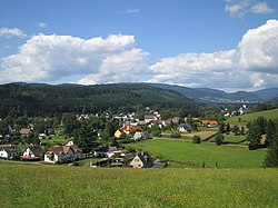 View on Karlovice | |
 Flag  Coat of arms | |
 Karlovice Location in the Czech Republic | |
| Coordinates: 50°6′20″N 17°26′45″E / 50.10556°N 17.44583°ECoordinates: 50°6′20″N 17°26′45″E / 50.10556°N 17.44583°E | |
| Country | |
| Region | Moravian-Silesian |
| District | Bruntál |
| First mentioned | 1558 |
| Area | |
| • Total | 21.60 km2 (8.34 sq mi) |
| Elevation | 480 m (1,570 ft) |
| Population (2020-01-01[1]) | |
| • Total | 1,017 |
| • Density | 47/km2 (120/sq mi) |
| Time zone | UTC+1 (CET) |
| • Summer (DST) | UTC+2 (CEST) |
| Postal code | 793 26 |
| Website | www |

Karlovice (German: Karlsthal) is a municipality and village in Bruntál District in the Moravian-Silesian Region in north-eastern Czech Republic. It has about 1,000 inhabitants.
During the German occupation of Czechia (World War II), the Germans operated the E733 forced labour subcamp of the Stalag VIII-B/344 prisoner-of-war camp in the village.[2]
Administrative parts[]
Village of Zadní Ves is an administrative part of Karlovice.
Gallery[]

Baroque Church of Saint John of Nepomuk

Museum in Karlovice


References[]
- ^ "Population of Municipalities – 1 January 2020". Czech Statistical Office. 2020-04-30.
- ^ "Working Parties". Lamsdorf.com. Archived from the original on 29 October 2020. Retrieved 3 April 2021.
| Wikimedia Commons has media related to Karlovice (Bruntál District). |
| Authority control: National libraries |
|---|
This Moravian-Silesian Region location article is a stub. You can help Wikipedia by . |
Categories:
- Populated places in Bruntál District
- Villages in Bruntál District
- Moravian-Silesian Region geography stubs